CVNP gets $14 million to stabilize Cuyahoga River along Towpath Trail, scenic railroad
Cuyahoga Valley National Park has received about $14 million through the Great American Outdoors Act for river stabilization work along the Cuyahoga River, near the Ohio & Erie Canal Towpath Trail and the tracks for Cuyahoga Valley Scenic Railroad.
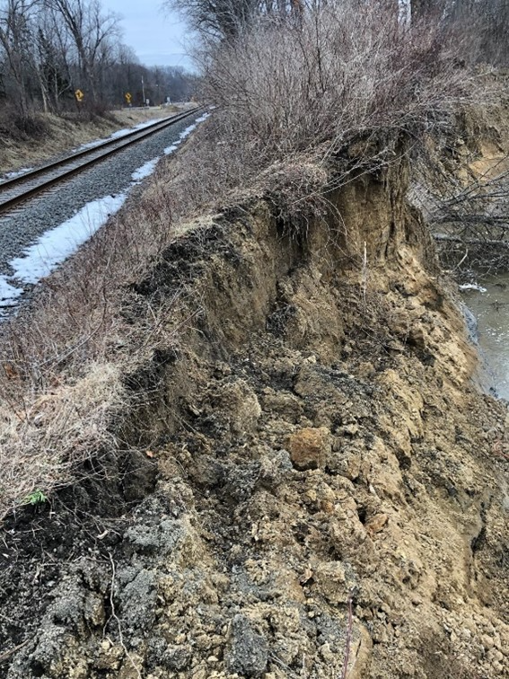
The work will stabilize the riverbank at sites along the Cuyahoga River where erosion threatens the Towpath Trail and the tracks, the national park said.
The work is expected to begin this month and continue through early 2025. Updates, including any necessary short-term closures, will be posted on the park website, nps.gov/cuva.
"The Towpath Trail and the Cuyahoga Valley Scenic Railroad are centerpieces of the park experience that are very close to the Cuyahoga River. Being that close to the river offers beautiful views, but it also presents constant and costly maintenance challenges," CVNP Superintendent Lisa Petit said in a statement. “This project will allow us to proactively manage infrastructure that provides safe and enjoyable recreational experiences while we protect and enhance our most important natural resource, the Cuyahoga River."
The eight locations include two sections of the Cuyahoga Valley Scenic Railroad and six locations along the Ohio & Erie Canal Towpath Trail in Summit and Cuyahoga counties. The sites were identified by the National Park Service based on existing bank erosion and the proximity to the trail and railroad, the park said.
Locations where work will be done in Cuyahoga Valley National Park
The eight sites include:
• CVSR Milepost 64.1: The existing riverbank is located on the outside of a bend in the Cuyahoga River and is severely eroding along the bank adjacent to the Cuyahoga Valley Scenic Railroad.
• Towpath Fitzwater: Due to erosion, the top of the riverbank is about 4 feet from the Towpath Trail.
• Towpath Buckeye: Due to erosion, the top of the steep bank is about 4 feet from the Towpath Trail.
• CVSR Milepost 59.3: The Cuyahoga River at this location is entrenched to the shale bedrock with limited connectivity to the adjacent low-lying floodplains. Severe erosion and sloughing are present along the bank due to the force of the river.
• Towpath Mudcatcher: Erosion has caused the top of bank to encroach within about 2 feet of the Towpath Trail.
• Towpath Station Road South: Bank erosion has caused previously placed rock riprap to become exposed and portions of the Towpath Trail to become damaged.
• Towpath Mile Marker 20 South: Scouring has eroded the riverbank at a sharp bend in the river.
• Peninsula Connector (a connector trail of the Towpath Trail): Erosion has occurred along the bank near a former low-head dam and mill foundation, revealing shale bedrock outcrops.
"Due to natural processes, the Cuyahoga River has migrated from its historic location over time. This migration has jeopardized the future stability of the Ohio & Erie Canal Towpath Trail and the Cuyahoga Valley Scenic Railroad at the eight locations," the park said in a statement. "Both the Ohio & Erie Canal Towpath Trail and the Cuyahoga Valley Scenic Railroad are important and frequently used park features. Both of the features are located within protected historic districts, and a portion of the Towpath Trail is a National Historic Landmark. Bank stabilization is necessary to protect the Ohio & Erie Canal Towpath Trail and the Cuyahoga Valley Scenic Railroad from the erosive forces of the Cuyahoga River."
Once the design is complete, the national park said work will include clearing the riverbank, placing riprap and live stakes (branches placed directly into the soil that will root and grow), regrading and planting native vegetation to stabilize the soil.
The park earlier this year conducted an emergency riverbank stabilization due to "significant erosion" from the Cuyahoga River at another site in the park, in Brecksville near the Columbia Run picnic area.
Cuyahoga River erosion in CVNP:Emergency repairs affect scenic railroad operations along Cuyahoga River in national park
At the time, the Cuyahoga Valley Scenic Railroad had canceled all runs on its National Park Scenic route due to the erosion near the railroad tracks.
The railroad, which is celebrating its 50th anniversary this year, returned to its normal train schedule in July, with the National Park Scenic returning to running five days a week, Wednesday through Sunday, with trips departing from the railroad’s three main boarding stations, including Akron Northside, Peninsula and Independence. The Explorer also returned in July.
Contact Beacon Journal reporter Emily Mills at emills@thebeaconjournal.com and on Twitter @EmilyMills818.
This article originally appeared on Akron Beacon Journal: CVNP gets $14 million to stabilize Cuyahoga River after erosion
