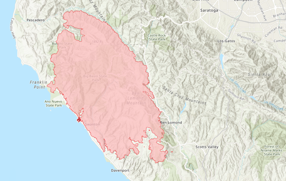
CZU Lightning Complex Fires Burn 74K Acres, 1 Dead
BAY AREA, CA — Some 77,000 people were chased from their homes by the cluster of fires ravaging Santa Cruz Mountains in San Mateo and Santa Cruz counties. The fires known as the CZU Lightning Complex fires scorched 74,000 acres and was just 8 percent contained as of Sunday night.
Stretched thin by the hundreds of wildfires burning in California, crews managed to gain ground on the blaze Saturday, but the weather is expected to turn on firefighters Sunday and Monday with red flag wind conditions and more dry lightning.
"Firefighters are aggressively taking suppression action on the CZU Lightning Complex. The fire continues to burn in Southern San Mateo County and Northern Santa Cruz County," according to Cal Fire. "The fires continue to actively burn above the marine layer in the heavy timber and thick undergrowth...Firefighting resources are limited due to the number of fires burning throughout California. Limited visibility due to smoke is hampering aircraft operations."
What it’s like driving through a wildfire at night #CZULightingComplex pic.twitter.com/LdkZBBp1Eb
— CAL FIRE CZU (@CALFIRECZU) August 23, 2020
Cal Fire is warning residents that more evacuation orders are likely to come.
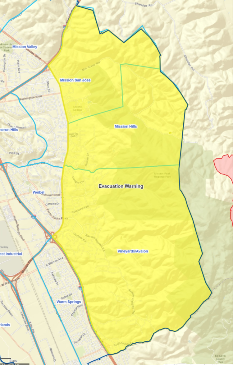
On Sunday afternoon, the City of Fremont warned residents to be prepared to evacuate as the neighboring SCU Lightning Complex fire heads toward the Mission Hills neighborhood.
As of Sunday morning, new closures were issued including all of Soquel Demonstration State Forest, and large portions of The Forest of Nisene Marks State Park.
Homes and buildings destroyed in the CZU Lightning Complex number 163, and 24,000 more are threatened. The number of structures destroyed is expected to climb as three additional damage inspection teams arrive on scene, for a total of five damage inspection teams.
Some 77,000 people have been evacuated from the areas surrounding the fires, Cal Fire said Sunday morning. Five looters have been arrested after targeting evacuated homes, the Santa Cruz County Sheriff's Office said.
READ MORE: Thieves Target California Firefighter, Then Came The Scammers
A civilian has been killed in the fire, and others are reported missing. The public is urged to contact law enforcement if they haven't heard from loved ones. Related: Man Found Dead In CZU Lightning Complex Fires: Santa Cruz County
Officials continue to stress that people who live in evacuation zones should flee immediately and not return for any reason. Firefighters are most concerned about fires burning near the most populous areas: along Empire Grade Road, near Bonny Doon and in the Highway 9 corridor.
Many have flouted evacuation orders in attempt to protect their homes, including three people who were rescued overnight Thursday, Cal Fire said. Some firefighters have been forced to stop battling back flames to perform rescues. Law enforcement officers have also had to put their regular duties on pause to save people who have stayed behind, officials said.
If you're missing medication, contact your doctor instead of trying to return home, officials said.
If you've left a pet behind, contact animal control officials. In Santa Cruz, the Santa Cruz County Animal Shelter is caring for wildfire evacuees' pets for free; call the shelter at 831-471-1182 to coordinate emergency pet services, such as rescues.
First responders are working with extremely limited resources as fires burn across the Golden State.
Firefighters are normally working with 10 to 20 times as many resources for a fire the size of the CZU August Lightning Complex Fires, Cal Fire said. Firefighters are working double- or triple-shifts, fighting flames in areas that may have never seen wildfire before.
There are nearly 1,200 first responders on scene, including some 100 law enforcement officers who are patrolling the evacuation area, keeping an eye out for people who have entered for the wrong reasons, officials said.
Five people were arrested Friday morning in the Fall Creek Road area of Santa Cruz County with two carloads full of stolen property, according to the Santa Cruz County Sheriff's Office.
One car stopped, but another tried to flee and wound up in a ditch, the sheriff's office said. Santa Cruz County residents who see suspicious security camera footage are asked to immediately contact dispatchers at 831-471-1121.
Air quality has reached has reached "very unhealthy" and "hazardous" levels on the Air Quality Index and the public is urged to stay inside and reduce activity.
More than a dozen state parks in the area have closed amid the fires. See which have been affected by closures here.
Among the list of shuttered parks is the 18,000-acre Big Basin Redwoods State Park, which is thought to have sustained serious damage to historic buildings and trees.
"We are devastated to report that Big Basin, as we have known it, loved it, and cherished it for generations, is gone," wrote local preservationist group Sempervirens Fund, which was founded to advocate for the preservation of the redwoods in the area now known as Big Basin. "Early reports are that the wildfire has consumed much of the park's historic facilities. We do not yet know the fate of the park's grandest oldest trees."
Read: Santa Cruz County's Big Basin 'As We Have Known It ... Is Gone'
Santa Cruz's boardwalk and nearby parking lots were also closed, though the area is not threatened.
The county urges the public to be wary that while sore throat and dry cough can be symptoms of both smoke exposure and COVID-19, symptoms such as fever, chills, body aches and muscle could be tied to the coronavirus. Check your symptoms here through the Centers for Disease Control and Prevention self-checker guide.
Learn more about air quality levels here and see who is most at risk here.
Donations are sought for evacuees sheltering in Santa Cruz County. The public may visit the Santa Cruz County Warehouse (1082 Emeline, Santa Cruz) with donations such as large tents, sleeping bags, blankets, pillows, tarps, hand sanitizer, personal hygeine products, toiletries, storage bins, coloring books and crayons, surgical masks, empty spray bottles, bottled water and granola or energy bars.
Road Closures
Road closures are fluid and being coordinated with evolving evacuation warnings and orders.
San Mateo County
Pescadero Creek Road between Alpine and Cloverdale Rd. Cloverdale Road between Pescadero Creek Road and Gazos Creek. Whitehouse Canyon Road at Highway 1 Portola Heights Road at Skyline State Route 1 at Rossi Road State Route 1 at Ano NuevoSanta Cruz County
State Route 1 at Shaffer Road to Ano Nuevo State Route 9 at Lower Glen Arbor to Rincon Trail head Westbound Zayante at Graham Hill Dr to Lockwood Empire Grade at Heller Drive Westbound State Route 35 at Upper Zayante into San Mateo County Westbound State Route 236 at Jamison Creek Pine Flat at Empire Grade Ice Cream Grade at Empire Grade Felton Empire at Fall Creek Empire Grade at Smith Grade Empire Grade at Felton Empire Bonny Doon Rd at Pine Flat Alba Rd at Empire Grade State Route 35 at Bear Creek Rd to Boulder Creek Granite Creek at Scotts Valley, this includes southbound offramp closure at Highway 17 at Granite Creek Westbound Mount Hermon at La Modrona to Graham Hill Road Zayante at State Route 35
Evacuation Orders
Plan. Prepare. Stay Aware.
Remember the Six P's
-People and pets
-Papers
-Prescriptions
-Pictures
-Personal Devices
-"Plastic" (Credit/ATM Cards) https://t.co/evYmdBqIzA
— Caltrans District 4 (@CaltransD4) August 20, 2020
SAN MATEO COUNTY:
Communities of Loma Mar and Dearborn Park Area (Zone SMC E018) Pescadero Creek County Park Area (Zone SMC E024) Butano Community Area (Zone SMC E098) Butano State Park Area including Barranca Knolls Community (Zone SMC E019) Butano Creek Drainage (Zone SMC E055) South Skyline Blvd. Area near Highway 9 (SMC E049) Russian Ridge Open Space Reserve Area (Zone SMC E027) Middleton Tract Area (Zone SMC E044) Portola Redwoods State Park and the Portola Heights Community Area (Zone SMC E048) Pescadero Beach Area (Zone SMC E075) Bean Hollow Area (Zone SMC E042) Pescadero Area (Zone SMC E043) San Gregorio Area (Zone SMC E022) La Honda Area (Zone SMC E028) Red Barn Area (Zone SMC E010) Russian Bridge Open Space Area (Zone SMC E027) Skylonda Area (Zone SMC E012) Langley Hill Area ( Zone SMC E010) Bean Hollow Area (Zone SMC E042) (8/20/2020 6:00 pm)SANTA CRUZ COUNTY: Waterman Gap Loop, Upper HWY 236, Boulder Creek Golf Course, Heartwood Hill, Lodge Road, Community of Little Basin, Lower China Grade, Upper China Grade, Community of Kings Hwy, Lower Jamison Creek, Gallion Heights, Fallen Leaf Neighborhood, Foxglove Lane (Zones CRZ10, CRZ13, BOU36, BOU20, BOU30, BOU31, BOU36, BOU37, BOU21) Saratoga Toll Road, San Lorenzo Park, Riverside Grove-Community of Teilh Drive, Wildwood Road (BOU38, BOU39, BOU40, BOU41, BOU42, BOU43) Everyone on Empire Grade Road, from Felton Empire north, all of Pine Flat Road, all of Ice Cream Grade, Bonny Doon Road, in between Pine Flat Road, Martin Road, and all associated side streets are under an evacuation order. (CRZ1, CRZ2, CRZ3, CRZ4, CRZ5, CRZ10, CRZ11, CRZ12, CRZ13, CRZ14, CRZ15) Bonny Doon south of Ice Cream Grade, to include Pine Flat Road South is now under an evacuation order. (CRZ7, CRZ8) Areas of Alba Road, Hubbard Gulch and Fanning Grade. (BEN 1) All areas of Ben Lomond (Zones BEN 2 – BEN 5) The area of Lompico (Zones ZAY 11, ZAY 12) All areas adjacent to the Bonny Doon and San Lorenzo Valley should be prepared to evacuate if necessary. (CRZ7, CRZ8) Areas West of Highway 9 to Empire Grade South from Bear Creek Road to Felton, this includes Ben Lomond Paradise Park (Zones: CRZ 63, CRZ 64) University of California Santa Cruz, campus only (Zone: SCZ 4) The areas of Zayante Canyon (Zones: ZAY 1 – ZAY 17) Scotts Valley West of State Route 17 (Zones: SCO 1-5, SCO 7, SCO 14-20, SCO 21 – SCO 25) Davenport south (Zones: CRZ 6, CRZ 9, CRZ 17) All areas of Felton (Zones: FEL 1– FEL6)
Evacuation Centers
San Mateo County
Half Moon Bay High School, 1 Lewis Foster Drive, Half Moon Bay (AT CAPACITY)
San Mateo Event Center, 1346 Saratoga Drive
Santa Cruz County
Twin Lakes Church, 2701 Cabrillo College Drive
Santa Cruz
Santa Cruz County Fairground, 2601 E. Lake Avenue in Watsonville
Santa Cruz Civic Auditorium, 307 Church Street, Santa Cruz (AT CAPACITY)
Seventh Day Adventist Camp Grounds, 1931 Soquel San Jose Rd (AT CAPACITY)
Cabrillo College, 6500 Soquel Drive, Aptos CA
Santa Cruz Bible Church, 440 Frederick Street, Santa Cruz
Simpkins Family Swim Center, 919 17th Ave (ADA only)
Twin Lakes Church, 2701 Cabrillo College Drive
Soquel
Santa Cruz Seventh Day Adventist Conference Grounds (1931 Soquel-San Jose Road, Soquel)
Congregational Church of Soquel parking lot (4951 Soquel Dr.); bathrooms open to evacuees
Watsonville
Santa Cruz County Fairground (2601 E. Lake Avenue, Watsonville)
Lakeview Middle School (2350 E Lake Ave., Watsonville)
Animal Evacuation Center:
Santa Cruz County Fairgrounds, 2601 E. Lake Avenue in Watsonville
Large farm animals are being accepted at Cowpalace. For information and assistance contact (650) 450-0520.
HERE TO HELP: CZU Crew 1 is returning from conducting emergency evacuations, and making sure people are out of harms' way! #ThisIsCALFIRE Thank you to ALL first responders. #StrongerTogether2020 pic.twitter.com/4wC6MURYMJ
— CAL FIRE CZU (@CALFIRECZU) August 21, 2020
This article originally appeared on the Santa Cruz Patch

