Dangerous cold returns, and then a big storm is likely to deliver snow and rain
Strong wind and arctic air will combine to produce dangerous wind chills Friday into Saturday before a storm that's likely to start as snow before changing to rain Sunday into Monday, according to the National Weather Service.
"Confidence is increasing in a winter storm impacting the region late Sunday night into Monday," the Weather Service says. "More rain than snow is expected along the coast with the best chance of significant snow accumulations across the distant interior."
Before the storm, residents of Southern New England will have to deal with arctic air and dangerous wind chills. The weather service has issued a wind advisory from 11 a.m. Friday morning until 5 a.m. Saturday and a wind chill advisory from 7 p.m. Friday until noon Saturday.
With the north wind blowing at 18 to 21 mph and the temperature plummeting to about 5 degrees tonight in Providence, the wind chill will drop as low as 20 degrees below zero, according to the Weather Service.
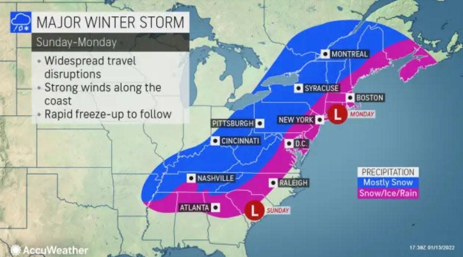
Get ready: A major snowstorm is forecast to roar across the Midwest, South and East Coast
"The cold wind chills could cause frostbite on exposed skin in as little as 30 minutes," the Weather Service says. "Use caution while traveling outside. Wear appropriate clothing, a hat, and gloves."
A coastal storm passing well offshore Friday will likely bring some rain, "ending as snow across parts of Eastern Massachusetts and Rhode Island," the Weather Service says.
Expect cloudy skies Friday and a high near 40 in Providence with temperatures falling.
The high Saturday should reach just 14 degrees despite sunny skies. The wind will stay strong, blowing from the northwest at 13 to 15 mph with gusts up to 28 mph.
[Strong Storm Late Sunday night/Monday]
Greatest risk for significant snow will be back across the interior especially towards the Berkshires/Northern Worcester Hills. Rain is favored along the Boston to Providence corridor, but a brief period of snow is possible at the start. pic.twitter.com/TUzd5TjwYx— NWS Boston (@NWSBoston) January 13, 2022
A big storm that's dipping into the United States from Western Canada, a "Saskatchewan Screamer," will move across the Midwest, the South and up the East Coast Sunday night.
"Lingering cold air will allow initial (precipitation) to fall as snow," the Weather Service says. "But as the increasing low level east-southeast winds warm the low level air, expect the snow to change to rain."
The "best chance" for the changeover is in Rhode Island, Eastern and Central Massachusetts, as well as much of Connecticut, the Weather Service says.
The storm brings the "potential for several inches of snow in the interior, while eastern areas may get a coating to an inch or two before changeover to rain," the Weather Service says.
AccuWeather Senior Meteorologist Bill Deger said, "Enough cold air is likely to be in place for an all or mostly snow event from near and west of Interstate 81 corridor in the Northeast states, while near and south and east of I-95, rain is likely to be the primary form of precipitation."
However, Deger noted that a shift in the track to the east could change conditions dramatically.
"Should the storm manage to drift 50 miles or so off the coast while heading northward, I-95 cities from Washington, D.C., to Philadelphia, New York City and Boston could be buried in snow with little or no rain and ice mixing in," Deger said.
jperry@providencejournal.com
(401) 277-7614
On Twitter: @jgregoryperry
Be the first to know.
Sign up for our breaking news alerts
This article originally appeared on The Providence Journal: RI weather: Dangerous cold returns before storm brings snow and rain

