Active severe weather day winding down across Ontario, Quebec
7:38 p.m. EDT - Eastern Ontario and southern Quebec can breathe a little easier Thursday night after all tornado watches and warnings dropped throughout the region.
Severe thunderstorm watches and warnings continued Thursday evening across parts of the Quebec's Eastern Townships and up the St. Lawrence River toward Quebec City. These storms will push east and eventually clear out of the region around sunset.
PHOTOS/VIDEOS: Tornado touches down in Barrhaven, south Ottawa
Ottawa and Montreal will see calm conditions and seasonal temperatures during the day Friday, which will aid folks looking to clean up any damage from Thursday's storms.
The vigorous thunderstorms produced damage across eastern Ontario and southern Quebec, spawning at least one confirmed tornado near Ottawa and widespread wind damage throughout portions of both provinces.
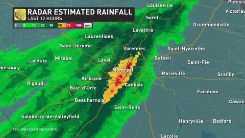
These are the same storms that produced damage in eastern Ontario earlier Thursday afternoon. Localized flooding has been reported throughout Metro Montreal and southern Quebec as a result of the very heavy rainfall in these severe storms.
Victoria Underpass #tornade #tornadowatch #montreal pic.twitter.com/JfzRGeaFO4
Victoria Underpass Rabbi Yisroel Bernath on Twitter: "Victoria Underpass #tornade #tornadowatch #montreal pic.twitter.com/JfzRGeaFO4 / Twitter" Rabbi Yisroel Bernath on Twitter: "Victoria Underpass #tornade #tornadowatch #montreal pic.twitter.com/JfzRGeaFO4 / Twitter" Rabbi Yisroel Bernath on Twitter: "Victoria Underpass #tornade #tornadowatch #montreal pic.twitter.com/JfzRGeaFO4 / Twitter" Rabbi Yisroel Bernath on Twitter: "Victoria Underpass #tornade #tornadowatch #montreal pic.twitter.com/JfzRGeaFO4 / Twitter"
— Rabbi Yisroel Bernath (@montrealrabbi) Rabbi Yisroel Bernath on Twitter: "Victoria Underpass #tornade #tornadowatch #montreal pic.twitter.com/JfzRGeaFO4 / Twitter"
Numerous photos and videos posted to social media on Thursday afternoon showed at least one tornado in eastern Ontario with the first line of storms that went through around the lunch hour.
Hydro Quebec reported more than 490,000 customers without power throughout the province by the middle of Thursday afternoon, with the vast majority of outages in areas getting hit by today's storms. Many of these power outages were the result of transmission lines proactively shut down to protect from damage as a result of forest fires up north.
However, the number of storm-related outages likely numbered in the tens of thousands by 5:45 p.m. local time. These outages will take longer to restore than outages prompted by wildfires.
@weathernetwork #ONStorm Half Moon Bay, Nepean pic.twitter.com/SNMTA7gjPk
Vanessa Dirienzo on Twitter: "@weathernetwork #ONStorm Half Moon Bay, Nepean pic.twitter.com/SNMTA7gjPk / Twitter" Vanessa Dirienzo on Twitter: "@weathernetwork #ONStorm Half Moon Bay, Nepean pic.twitter.com/SNMTA7gjPk / Twitter" Half Moon Bay, Nepean Vanessa Dirienzo on Twitter: "@weathernetwork #ONStorm Half Moon Bay, Nepean pic.twitter.com/SNMTA7gjPk / Twitter"
— Vanessa Dirienzo (@VanessaDiri) Vanessa Dirienzo on Twitter: "@weathernetwork #ONStorm Half Moon Bay, Nepean pic.twitter.com/SNMTA7gjPk / Twitter"
The original forecast from earlier in the day Thursday continues below.
Thursday
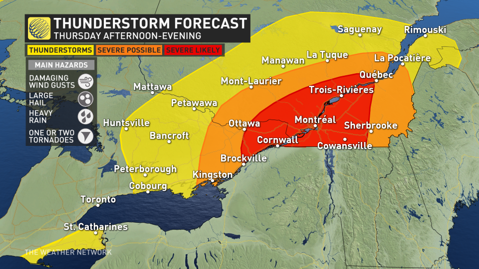
Areas: Eastern Ontario and southern Quebec
Timing: Thursday afternoon and evening
Weather: Several of Canada's major cities, including Ottawa, Kingston, Montreal and surrounding regions, are within an environment which could produce tornadoes, damaging winds and heavy rainfall on Thursday. Much of eastern Ontario and southern Quebec should be weather-aware Thursday late afternoon and evening.
RELATED: Tornado 101: What you need to know about staying safe
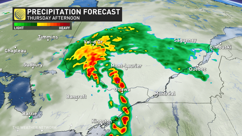
Depending on how fast the morning showery commute clears out will determine how severe the environment sets up in behind it.
A cold front that follows will trigger thunderstorms in eastern Ontario just after the lunch hour. Into the afternoon, storms will start to strengthen, initially into discrete storms with supercell and tornado potential, heading east into southern Quebec.
MUST SEE: If you're camping, make sure you have a plan for severe weather
This persists into the evening commute and dinner hour until the storms line out later on Thursday. The risks would then shift from tornadoes into damaging straight line winds.
There is the threat for all types of hazards with these storms on Thursday, so be sure to stay up-to-date on the weather alerts and have a safety plan at home or on the road.
WATCH: What to do if a tornado warning occurs while in an apartment
Prepare
Stay alert and monitor the forecast for updates. Have a plan and a place to head indoors if the weather changes.
According to ECCC, in the event of a tornado, or if a tornado warning is issued for your area, it is recommended you take the following actions: Go indoors to a room on the lowest floor, away from outside walls and windows, such as a basement, bathroom, stairwell or interior closet. Leave mobile homes, vehicles, tents, trailers and other temporary or free-standing shelter, and move to a strong building if you can.
"As a last resort, lie in a low spot and protect your head from flying debris," ECCC says. "Lightning kills and injures Canadians every year. Remember, when thunder roars, go indoors!"
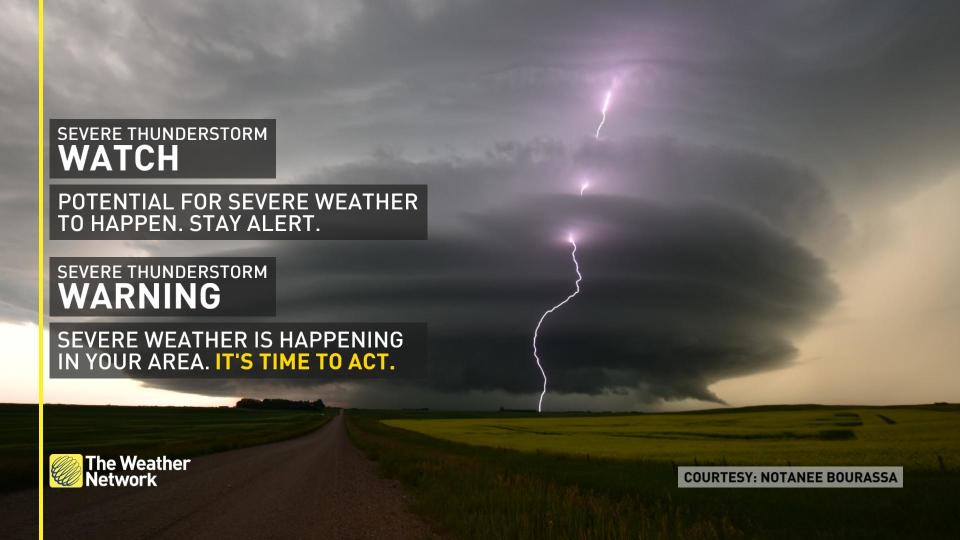
Watches mean conditions are favourable for the development of severe thunderstorms. Warnings mean they are imminent or are occurring in your area and you should take shelter immediately.
DON'T MISS: Don’t fall victim to these seven dangerous tornado myths
WATCH BELOW: Follow these steps to stay safe from a tornado when inside your home
Thumbnail image courtesy of Arthur Veys in Montreal, Quebec.
Be sure to check back for the latest weather updates across Ontario and Quebec.

