Dangerous wind chills in Green Bay means residents should layer up and limit outside activities
GREEN BAY – Fun fact for your next dinner party: the word "apricity" means the warmth of the sun in winter. Rare though the word is, Green Bay's sunshine is a bitter, biting one that will be anything but rare.
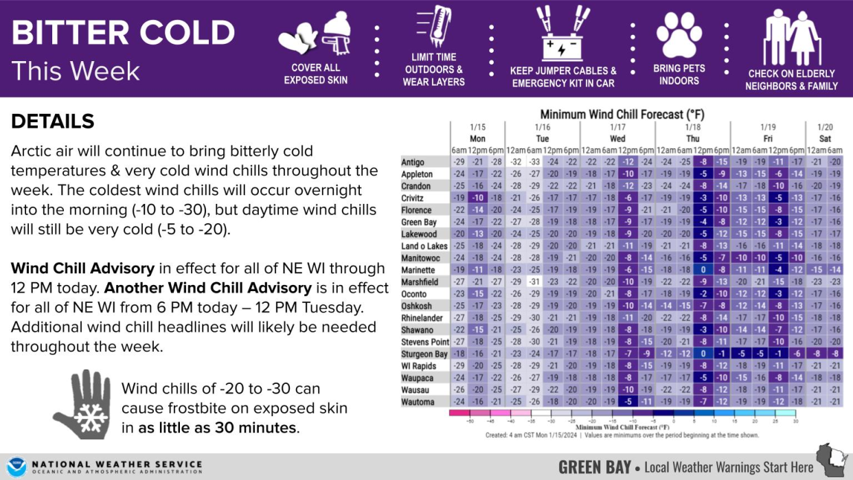
The National Weather Service Green Bay has put into effect a wind chill advisory for all of northeastern Wisconsin, with wind chills reaching anywhere from minus-20 to minus-25 by Monday evening, according to meteorologist Timm Uhlmann.
Northeastern Wisconsin's bitter cold weather comes in the wake of its first blizzard, which dumped 13.5 inches of snow in the Green Bay area, and 14 to 15 inches of snow in some areas of Brown County, Uhlmann said.
People braving the outdoors will want to layer up as much as possible, making sure to minimize exposed skin, Uhlmann said.
"The main concern is always concerned skin, so any exposed areas that can lose heat or be exposed to the wind, those minus-20 to -25 values which we'll have tonight," Uhlmann said. "Frostbite can start within 30 minutes or so when you get to those minus-20 temperatures."
Uhlmann suggests wearing a hat, gloves, face covering and thick long socks.
It is cold outside this morning!🥶🥶🥶
❄️ Dress in layers
❄️ Wear a hat, scarf & gloves
❄️ Limit the time you spend outside#ReadyWI #wiwx pic.twitter.com/IVAU61UBYO— ReadyWisconsin (@ReadyWisconsin) January 15, 2024
Drivers should commute with caution for a series of reasons, Uhlmann said, especially on untreated roads where melting from other cars and the sunshine may create new patches of ice. But even roads treated with salt become considerably less effective in such frigid temperatures.
With all the snow out there, sun glare can also present difficulties, Uhlmann said, and he recommends drivers wear sunglasses on the road.
Uhlmann suggests drivers keep their distance from other vehicles, drive slowly and be patient with other drivers on the road.
Do you know the signs of frostbite and hypothermia?
👉 If you go outside in cold weather, bundle up, wear gloves, & a warm hat.
Learn more: https://t.co/D3BroGfZjc#ReadyWI #wiwx pic.twitter.com/5v1MY6otHt— ReadyWisconsin (@ReadyWisconsin) January 14, 2024
Temperatures will continue to be below zero and in the single digits until Wednesday, where it may reach 10 to 11. And while Monday evening will see the most dangerous cold temperatures, Tuesday morning is expected to be blustery, overcast and even colder than Monday morning, Uhlmann said.
It won't get much warmer than that until Sunday, Uhlmann said, when we'll get some highs in the 20-degree range.
Relatively warmer weather is expected to continue Jan. 22 and 23, but until then, layer up, limit your time outside and give yourself and other drivers grace on the roads.
This article originally appeared on Green Bay Press-Gazette: Green Bay issues wind chill advisory following blizzard

