Lake-effect machine on autopilot as heavy snow in Ontario still ongoing
Mother Nature is trying to play catchup in Ontario after a slow start to winter. It's fair to say it's doing a good job of that in the snowbelt regions.
Going somewhere? Check out the current highway conditions before heading out!
The prolonged, multi-day, lake-effect snow setup, which began Saturday, will remain locked in place for the first half of this week for some areas.
Snow squall warnings and winter weather travel advisories remain in place for areas near Lake Huron, northern Georgian Bay and Lake Erie.
A reminder for those travelling in the snowbelt regions: Snow squalls cause weather conditions to vary considerably. Changes from clear skies to heavy snow within just a few kilometres are common. Travel is expected to be hazardous due to reduced visibility in some locations.
Dangerous winter travel continues
The same Arctic air bringing historically cold temperatures to the western half of North America is flooding into the Great Lakes, bringing some of the coldest temperatures we've seen so far this season.
For the first time this winter, Toronto reached the minus double-digit territory early Sunday morning as temperatures plummeted to -12.2°C. The latest date on record for a negative double-digit temperature is January 23, 2021.
Frigid winds flowing over the lakes will continue fuelling beefy lake-effect squalls off all five of the lakes through the first half of this week.
PHOTOS: Powerful snow squalls bury communities with knee-high totals
Snow squalls shifted north through the day on Sunday, and are now affecting the eastern shores of Lake Huron, Georgian Bay, Lake Erie, Lake Ontario and Lake Superior.
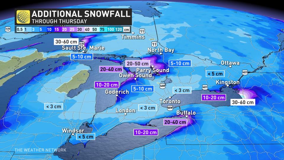
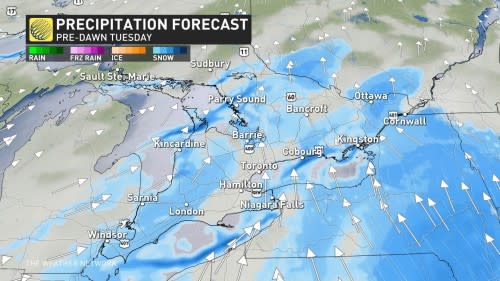
Coburg to Kingston, Bruce and Niagara peninsulas and Parry Sound will be directly affected by intense snow squall bands, with higher totals likely. Tuesday morning commutes will be greatly impacted. As the system departs lakes Erie and Ontario, squalls take a break, but a continued firehose of snow is anticipated for the Bruce Peninsula to Parry Sound through the evening, where regions may get hit hard with 20-50 cm of snow.
RELATED: Toronto bas tobogganing at 45 hills
Additionally, Tuesday will see some system snow sneak by as a low tracks across the U.S. Northeast. So, folks who have now been affected by the narrow band of intense, snowy weather will likely get a taste of flurries Tuesday.
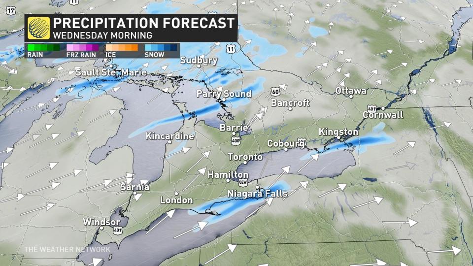
System snow begins across southern Ontario very early Tuesday morning. It will likely be short-lived for the southwest and Greater Toronto Area (GTA), but linger in Ottawa through the afternoon. Embedded within the 1-3 cm of widespread snow will be our persistent, lake-enhanced squalls.
RELATED: Why snow squalls are one of the hardest events to forecast
On Wednesday, an approaching cold front will amplify squalls by the afternoon and evening, leading to very intense weather to the aforementioned regions. Expect near zero visibility, with very heavy snowfall rates and blowing snow conditions.
Lake Superior shorelines will see some of the worst conditions with heavy snow and gusty conditions. 30-60+ cm of snow is possible to accumulate by Wednesday, on top of what they have already had. Consider postponing travel to snow squall-affected regions.
Cold temperatures will persist this week, with overnight lows bottoming out around -16°C for the Greater Toronto Area, and the low -20s for eastern Ontario. Wind chill values will make things feel even colder, so residents are being urged to dress warmly and watch for symptoms related to the cold weather.
The Majestic nature made ice formations Lake Erie conjured @weathernetwork @MurphTWN @KMacTWN @LakeErieNorth @StormhunterTWN @RachelSchoutsen @WxMelinda21 @martaczur @CBCNews @CTVToronto @CTVLondon @MattHamelTV @gtaweather1 @nadinehp4 @ThatMetGirl @NicoleKarkic #ShareYourWeather pic.twitter.com/kjwI5vy0Ne
The Majestic nature made ice formations Lake Erie conjured Ann Maurie on Twitter: "The Majestic nature made ice formations Lake Erie conjured @weathernetwork @MurphTWN @KMacTWN @LakeErieNorth @StormhunterTWN @RachelSchoutsen @WxMelinda21 @martaczur @CBCNews @CTVToronto @CTVLondon @MattHamelTV @gtaweather1 @nadinehp4 @ThatMetGirl @NicoleKarkic #ShareYourWeather pic.twitter.com/kjwI5vy0Ne / Twitter" Ann Maurie on Twitter: "The Majestic nature made ice formations Lake Erie conjured @weathernetwork @MurphTWN @KMacTWN @LakeErieNorth @StormhunterTWN @RachelSchoutsen @WxMelinda21 @martaczur @CBCNews @CTVToronto @CTVLondon @MattHamelTV @gtaweather1 @nadinehp4 @ThatMetGirl @NicoleKarkic #ShareYourWeather pic.twitter.com/kjwI5vy0Ne / Twitter" Ann Maurie on Twitter: "The Majestic nature made ice formations Lake Erie conjured @weathernetwork @MurphTWN @KMacTWN @LakeErieNorth @StormhunterTWN @RachelSchoutsen @WxMelinda21 @martaczur @CBCNews @CTVToronto @CTVLondon @MattHamelTV @gtaweather1 @nadinehp4 @ThatMetGirl @NicoleKarkic #ShareYourWeather pic.twitter.com/kjwI5vy0Ne / Twitter" Ann Maurie on Twitter: "The Majestic nature made ice formations Lake Erie conjured @weathernetwork @MurphTWN @KMacTWN @LakeErieNorth @StormhunterTWN @RachelSchoutsen @WxMelinda21 @martaczur @CBCNews @CTVToronto @CTVLondon @MattHamelTV @gtaweather1 @nadinehp4 @ThatMetGirl @NicoleKarkic #ShareYourWeather pic.twitter.com/kjwI5vy0Ne / Twitter" Ann Maurie on Twitter: "The Majestic nature made ice formations Lake Erie conjured @weathernetwork @MurphTWN @KMacTWN @LakeErieNorth @StormhunterTWN @RachelSchoutsen @WxMelinda21 @martaczur @CBCNews @CTVToronto @CTVLondon @MattHamelTV @gtaweather1 @nadinehp4 @ThatMetGirl @NicoleKarkic #ShareYourWeather pic.twitter.com/kjwI5vy0Ne / Twitter" Ann Maurie on Twitter: "The Majestic nature made ice formations Lake Erie conjured @weathernetwork @MurphTWN @KMacTWN @LakeErieNorth @StormhunterTWN @RachelSchoutsen @WxMelinda21 @martaczur @CBCNews @CTVToronto @CTVLondon @MattHamelTV @gtaweather1 @nadinehp4 @ThatMetGirl @NicoleKarkic #ShareYourWeather pic.twitter.com/kjwI5vy0Ne / Twitter" Ann Maurie on Twitter: "The Majestic nature made ice formations Lake Erie conjured @weathernetwork @MurphTWN @KMacTWN @LakeErieNorth @StormhunterTWN @RachelSchoutsen @WxMelinda21 @martaczur @CBCNews @CTVToronto @CTVLondon @MattHamelTV @gtaweather1 @nadinehp4 @ThatMetGirl @NicoleKarkic #ShareYourWeather pic.twitter.com/kjwI5vy0Ne / Twitter" Ann Maurie on Twitter: "The Majestic nature made ice formations Lake Erie conjured @weathernetwork @MurphTWN @KMacTWN @LakeErieNorth @StormhunterTWN @RachelSchoutsen @WxMelinda21 @martaczur @CBCNews @CTVToronto @CTVLondon @MattHamelTV @gtaweather1 @nadinehp4 @ThatMetGirl @NicoleKarkic #ShareYourWeather pic.twitter.com/kjwI5vy0Ne / Twitter" Ann Maurie on Twitter: "The Majestic nature made ice formations Lake Erie conjured @weathernetwork @MurphTWN @KMacTWN @LakeErieNorth @StormhunterTWN @RachelSchoutsen @WxMelinda21 @martaczur @CBCNews @CTVToronto @CTVLondon @MattHamelTV @gtaweather1 @nadinehp4 @ThatMetGirl @NicoleKarkic #ShareYourWeather pic.twitter.com/kjwI5vy0Ne / Twitter" Ann Maurie on Twitter: "The Majestic nature made ice formations Lake Erie conjured @weathernetwork @MurphTWN @KMacTWN @LakeErieNorth @StormhunterTWN @RachelSchoutsen @WxMelinda21 @martaczur @CBCNews @CTVToronto @CTVLondon @MattHamelTV @gtaweather1 @nadinehp4 @ThatMetGirl @NicoleKarkic #ShareYourWeather pic.twitter.com/kjwI5vy0Ne / Twitter" Ann Maurie on Twitter: "The Majestic nature made ice formations Lake Erie conjured @weathernetwork @MurphTWN @KMacTWN @LakeErieNorth @StormhunterTWN @RachelSchoutsen @WxMelinda21 @martaczur @CBCNews @CTVToronto @CTVLondon @MattHamelTV @gtaweather1 @nadinehp4 @ThatMetGirl @NicoleKarkic #ShareYourWeather pic.twitter.com/kjwI5vy0Ne / Twitter" Ann Maurie on Twitter: "The Majestic nature made ice formations Lake Erie conjured @weathernetwork @MurphTWN @KMacTWN @LakeErieNorth @StormhunterTWN @RachelSchoutsen @WxMelinda21 @martaczur @CBCNews @CTVToronto @CTVLondon @MattHamelTV @gtaweather1 @nadinehp4 @ThatMetGirl @NicoleKarkic #ShareYourWeather pic.twitter.com/kjwI5vy0Ne / Twitter" Ann Maurie on Twitter: "The Majestic nature made ice formations Lake Erie conjured @weathernetwork @MurphTWN @KMacTWN @LakeErieNorth @StormhunterTWN @RachelSchoutsen @WxMelinda21 @martaczur @CBCNews @CTVToronto @CTVLondon @MattHamelTV @gtaweather1 @nadinehp4 @ThatMetGirl @NicoleKarkic #ShareYourWeather pic.twitter.com/kjwI5vy0Ne / Twitter" Ann Maurie on Twitter: "The Majestic nature made ice formations Lake Erie conjured @weathernetwork @MurphTWN @KMacTWN @LakeErieNorth @StormhunterTWN @RachelSchoutsen @WxMelinda21 @martaczur @CBCNews @CTVToronto @CTVLondon @MattHamelTV @gtaweather1 @nadinehp4 @ThatMetGirl @NicoleKarkic #ShareYourWeather pic.twitter.com/kjwI5vy0Ne / Twitter" Ann Maurie on Twitter: "The Majestic nature made ice formations Lake Erie conjured @weathernetwork @MurphTWN @KMacTWN @LakeErieNorth @StormhunterTWN @RachelSchoutsen @WxMelinda21 @martaczur @CBCNews @CTVToronto @CTVLondon @MattHamelTV @gtaweather1 @nadinehp4 @ThatMetGirl @NicoleKarkic #ShareYourWeather pic.twitter.com/kjwI5vy0Ne / Twitter" Ann Maurie on Twitter: "The Majestic nature made ice formations Lake Erie conjured @weathernetwork @MurphTWN @KMacTWN @LakeErieNorth @StormhunterTWN @RachelSchoutsen @WxMelinda21 @martaczur @CBCNews @CTVToronto @CTVLondon @MattHamelTV @gtaweather1 @nadinehp4 @ThatMetGirl @NicoleKarkic #ShareYourWeather pic.twitter.com/kjwI5vy0Ne / Twitter" Ann Maurie on Twitter: "The Majestic nature made ice formations Lake Erie conjured @weathernetwork @MurphTWN @KMacTWN @LakeErieNorth @StormhunterTWN @RachelSchoutsen @WxMelinda21 @martaczur @CBCNews @CTVToronto @CTVLondon @MattHamelTV @gtaweather1 @nadinehp4 @ThatMetGirl @NicoleKarkic #ShareYourWeather pic.twitter.com/kjwI5vy0Ne / Twitter" Ann Maurie on Twitter: "The Majestic nature made ice formations Lake Erie conjured @weathernetwork @MurphTWN @KMacTWN @LakeErieNorth @StormhunterTWN @RachelSchoutsen @WxMelinda21 @martaczur @CBCNews @CTVToronto @CTVLondon @MattHamelTV @gtaweather1 @nadinehp4 @ThatMetGirl @NicoleKarkic #ShareYourWeather pic.twitter.com/kjwI5vy0Ne / Twitter"
A milder pattern is expected for several days during the final week of January, followed by a colder pattern once again for the start of February.
Stay with The Weather Network for the latest on this high-impact storm across Ontario.
Thumbnail image courtesy: Stephanie, taken in Barrie, Ont.

