David Weintraub: Tell commissioners enough is enough

As many of us know, Henderson County is putting the final touches on a Comprehensive Plan that will guide growth, development and land protection for decades to come. Commissioners allocated funds to hire consultants, to hold public hearings and to seek out public opinion on what land priorities the citizenry are asking for.
Seven thousand residents responded to the county’s recent survey and unsurprisingly they chose protecting open space and forests (55%) and natural areas and farmland (45%) as their priorities.T he results mirror more than a dozen surveys taken over the past three decades.
Clearly development in this region has changed the rural character of our community substantially. According to a UNC Charlotte Urban Institute Study, Henderson County’s population increased 92% from 1976 to 2006. However, developed land increased by a whopping 730%, more than eight times its population growth. This impacts our air quality, the biodiversity of wildlife, our clean water and by draining taxpayers dry.
The direct results on our rural character are stark. According to Comp Plan consultant Jake Petrosky of Stewart Inc., one third of our apple orchards were lost between 2002-2017. Petrovsky projects that at this rate Henderson County’s famed apples will be gone in 40 years. Imagine holding an Apple Festival featuring apples from China.
Many folks assume that development increases our tax base, bringing needed revenues into county offers, but that’s not always true. Back in 2008, the county did a study on the “Cost of Community Services.” Residential development brought in 86 cents for every dollar in community services it spent on additional roadways, schools, hospitals, etc. Only agriculture and commercial and industrial development provided a net gain to the county budget.
A recent study by Urban3 that looked at development in the Upstate of South Carolina provides additional meat on the bones. In that study, when growth was allowed to continue on its current trajectory, taxpayers shelled out more than twice as much money to pay infrastructure costs than the income generated from new real estate taxes. However, should the Upstate counties implement a compact development map that encourages development only where existing infrastructure already exists, those counties would see a net gain in income to their coffers. Therefore, incentivizing population growth where services exist promotes not only the financial health of the county but it preserves the natural beauty and livability of a community.
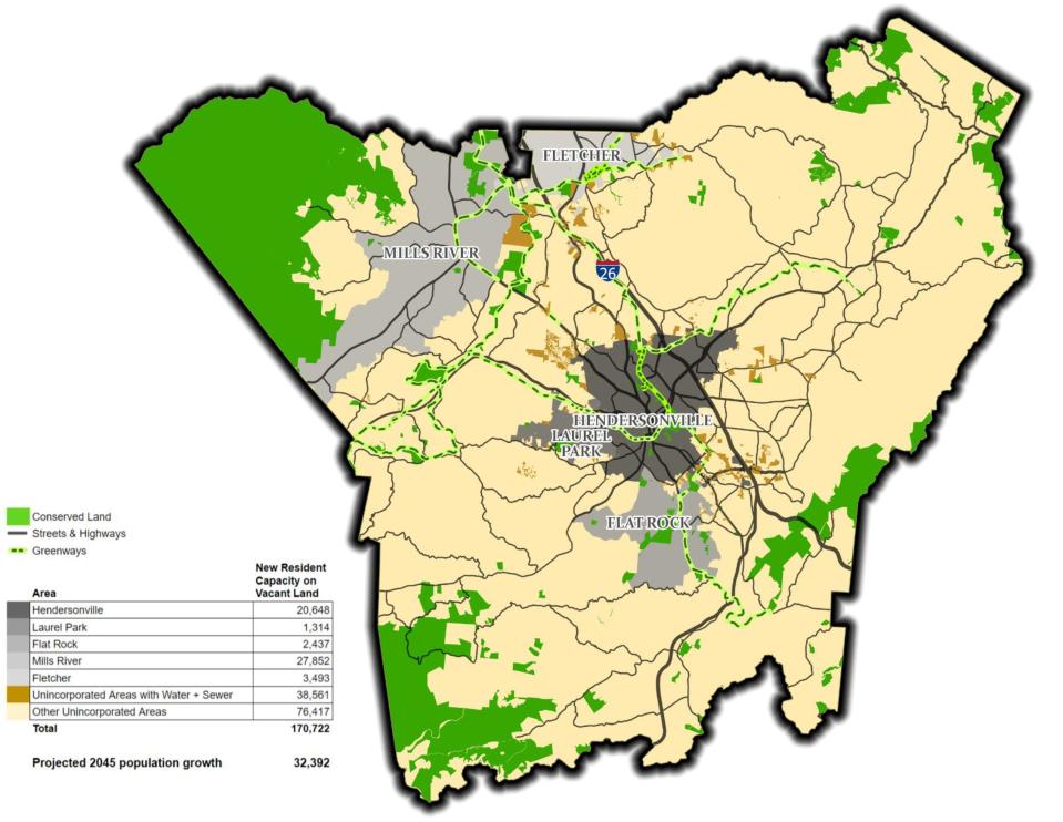
Yet current proposed Future Land Use Maps do nothing but promote sprawl which will result in our beautiful green spaces becoming nothing more than development gold, while our taxes go up, our quality of life goes down and our community is sliced and diced into a place that no one wants to live or work in. Current projections assume that our county will grow by 32,000 new residents in the next 20 years, but the county has plenty of space to accommodate new residents in areas where development and infrastructure already exist.
However, the current draft of the Future Land Growth Map is designed with the expectation of a population growth of over 170,000 sprinkled haphazardly all over the county, 5-6 times the number of new residents. By planning more infrastructure (water and sewer lines) beyond what is needed, we create a recipe for sprawl, ruining everything that is magical and beautiful about this place. Sprawl is the death of communities like ours because it kills it fiscally, aesthetically and environmentally.
Furthermore, the Board of Commissioners seems to be taking a major step backwards by proposing to increase development in floodplains, a lose-lose proposal. Do we really need to increase the likelihood of flooding, destruction of property and jeopardizing the lives of our residents just so developers can earn an extra buck?
There are others way to grow: 1) Create a local land conservation fund that stabilizes rural communities and offer opportunities to buy development rights from farmers so that farmers aren’t forced to sell the family farm to stay in business. 2) Create strict urban service boundaries that mandate that the area inside the boundary be used for urban development and the area outside be preserved in its natural state or used for agriculture. Currently the draft maps are so loosey goosey that sprawl will overwhelm community design and destroy what’s most precious about our community. 3) Lowering the density in rural communities to insure our countryside does not get segmented into mega-developments that destroy local ecosystems and damage scenic vistas. Studies in the past have shown that doing this can actually raise land values in the long run.
The original settlers of our area were the Cherokee. Their credo was living for the Seventh Generation. Future plans were viewed through the lens of its impact on descendants many generations from now. The results of this approach are striking. When European settlers arrived here, they found seemingly untouched rivers and streams, majestic mountains, and protected forestland and meadowland. Yet the Cherokee were very active managers of their land... for over 10,000 years.
What legacy do we want to leave to our children’s children children? Concrete canyons? MallWart type construction on every block? Rivers and streams that ooze chemicals and construction runoff and no longer support life?
The choice is ours. The decisions we make today will have everything to do with what our community looks like tomorrow. Tell our commissioners that the most important word when it comes to land protection is ENOUGH. Enough mega-development. Enough construction on steep slopes that threatens increasing landslides. Enough building on floodplains that threatens life and limb. Enough turning our green mountains and valleys into development gray.
Plan on attending the Sept. 6 county commissioners' meeting at the Historic Courthouse at 5:30 p.m. and tell them to listen to their constituency and protect our open space, farmland and forests. You can reach the commissioners at www.hendersoncountync.gov/boc. Let’s protect our community’s treasured birthright for many generations to come.
David Weintraub is a cultural preservationist, filmmaker and local environmental advocate who runs the Center for Cultural Preservation. Contact him at SaveCulture.org or 828-692-8062.
This article originally appeared on Hendersonville Times-News: Comprehensive plan: Tell commissioners enough is enough

