Decades-long phosphorus study of Lower Fox River shows why it's a big problem for Lake Michigan
The Fox River contributes more phosphorus to Lake Michigan than any other tributary. It's also the second largest contributor of sediment. And while Wisconsin has strict rules to limit the amount of phosphorus flowing into its waterways, a new report shows that it hasn’t been enough to turn the tide on the problem in the Lower Fox River watershed.
Scientists from the U.S. Geological Survey monitored phosphorus and sediment levels in Lake Winnebago, near De Pere and at the mouth of the river from 1989 and 2021. The overall finding in the more-than-three-decade study: more work needs to be done, especially as climate change brings heavier rain events that wash more nutrients into the water.
So why is too much phosphorus a problem? Have phosphorus levels gone down in the Lower Fox River watershed? And what’s being done to fix it? Here’s what to know.
Phosphorus enters waterways from point and nonpoint sources
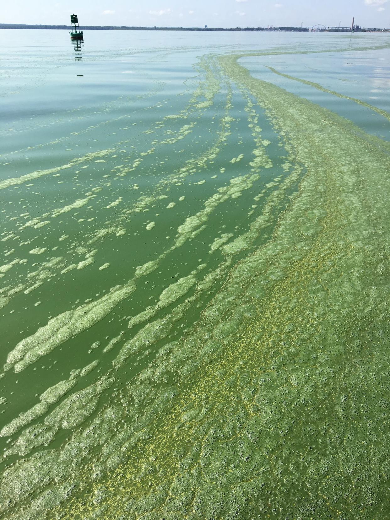
Phosphorus is an essential element needed for plants to grow. That’s why it’s a key ingredient in fertilizers on agriculture land. It is also present in manure, a natural fertilizer. Too much phosphorus, however, can pollute waterways and cause blue-green algae blooms when it’s washed into waterways during heavy rain events, which are becoming more common with climate change.
Phosphorus gets into waterways via point and nonpoint sources. Point sources are single, identifiable sources of pollution, such as factories and wastewater treatment plants. Nonpoint source pollution is runoff from the broader landscape.
While the Clean Water Act sets limits for pollutants from point sources, phosphorus and nitrogen are not included in those regulations, and the laws do not even include nonpoint sources, which account for more than 80% of phosphorus in Wisconsin waters.
Higher rainfall overriding decreases in phosphorus
There are a few parameters to consider when measuring the amount of phosphorus entering a waterway. One is the concentration, or the total amount present in the water, which can ultimately affect the biology of the river. Another is the total maximum daily load, or the amount that can enter a river, lake or stream without having it exceed its water quality standards and designated uses, like fishing and swimming.
Between 1989 and 2021, the total amount of phosphorus and sediment decreased at De Pere and the mouth of the Fox River, according to the report.
But due to the higher flow from increased precipitation, there was little change in phosphorus loading to the bay of Green Bay.
Even though the concentration of phosphorus is less, said Dale Robertson, a hydrologist at USGS and author on the report, increased rainfall is causing more of it to wash into the waterways. So while the amount of phosphorus in De Pere and the mouth of the Fox River is lower, the loading limits are still being exceeded because of the increased flow occurring in recent years.
Phosphorus likely settling into holes left behind from PCB dredging
Robertson doesn’t believe the lower amounts of phosphorus will last. In fact, one pollutant may be replacing another.
From 2004 to 2020, the river was dredged as part of an effort to get rid of PCBs, or polychlorinated biphenyls, left behind on the river bottom from the paper mill industry. The PCBs are responsible for the Lower Fox River and bay of Green Bay being designated as an area of concern, or one of the most polluted sites in the Great Lakes basin.
Robertson now fears phosphorus may be settling into deeper areas left behind from dredging to remove PCBs.
More: Authors of new book revisit epic battles to clean up PCBs from the Lower Fox River
Little change in Lake Winnebago
The study found that there has been little change in phosphorus concentrations at the outlet of Lake Winnebago and phosphorus loading has increased downstream, likely due to higher rainfall.
What happens in the Lower Fox River is controlled by Lake Winnebago upstream, Robertson said. There is a lot of phosphorus stored at the bottom of the lake and the amount that comes out of the lake is already at the threshold, he said.
Many of the farms and point sources are downstream of the lake, Robertson said, so efforts need to go even further to reduce phosphorus levels.
But it can take many years to see the impacts of conservation-based agriculture practices, he said.
Healthy soil practices, habitat restoration are reducing problem
Greg Baneck, a conservationist with Outagamie County’s land conservation department, has seen increased interest in farmers wanting to adopt conservation practices that prioritize soil health.
But there are still a lot of barriers that farmers face in switching to these practices, he said. Many farmers can't take on the financial risk, for one.
Funding from the Great Lakes Restoration Initiative has enabled counties in the watershed to hire staff that work with farmers to help them switch to conservation practices. Cost-sharing also helps reduce the risks to farmers' bottom lines, so they can try out equipment or practices for a few years to see how they work, he said.
Baneck said demonstration farms have been successful, and they also build lines of communication with farmers. Outagamie County has done a lot of this work in partnership with the Oneida Nation. For instance, the tribe leases land to the county for free. In turn, the county houses equipment that tribal and nontribal farmers can rent to try out. It also acts as a knowledge center where farmers can share ideas.
After decades of using soil-friendly agriculture practices, cleaning up waterways and restoring habitat on the reservation, the Oneida Nation has made great strides in reducing phosphorus runoff on its land. When Wisconsin adopted its phosphorus limits, the Oneida Nation voluntarily opted in as well.
The Oneida reservation sits within the Fox River watershed, and for a second year in a row, the creeks on the reservation met the phosphorus goals.
Monitoring helps figure out what practices work best
Phosphorus monitoring will continue at these sites in the Lower Fox River watershed, Robertson said, but more work needs to be done.
Additional monitoring in the watershed is helping to figure out what conservation-based practices are working best and where in the watershed these efforts should be prioritized, said Matt Komiskey, a USGS scientist who worked on the edge-of-field monitoring project, which is funded by the Great Lakes Restoration Initiative.
Komiskey said the project identifies how well specific conservation-based practices, like cover crops, are working to limit nutrient runoff at different scales, like on private fields and in nearby streams. It will help show farmers, landowners and other stakeholders what practices make the greatest difference in nearby streams and in the lake.
At the end of the day that's where these practices matter most, Komiskey said.
Caitlin Looby is a Report for America corps member who writes about the environment and the Great Lakes. Reach her at clooby@gannett.com or follow her on X @caitlooby.
Please consider supporting journalism that informs our democracy with a tax-deductible gift to this reporting effort at jsonline.com/RFA or by check made out to The GroundTruth Project with subject line Report for America Milwaukee Journal Sentinel Campaign. Address: The GroundTruth Project, Lockbox Services, 9450 SW Gemini Dr, PMB 46837, Beaverton, Oregon 97008-7105.
This article originally appeared on Milwaukee Journal Sentinel: Climate change driving more phosphorus into Lake Michigan

