Delaware to get heavy rain, potential flooding Friday evening, snow forecast for next week
Gear up for rainy weekend with possible flooding in store, followed by a chance of snow early next week.
The National Weather Service reports that the weekend weather pattern continues to be extremely active in the wake of an energetic jet stream and a pair of storms moving across the country.
Weekend rain, potential flooding coming through
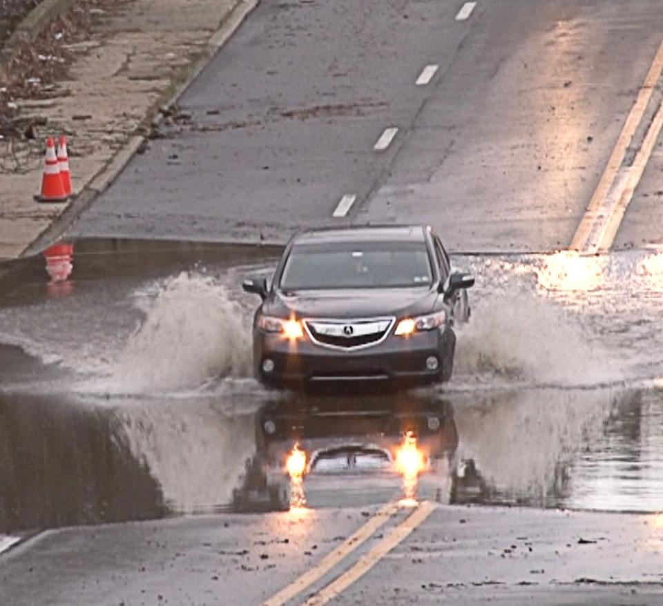
The Northeast is forecast to receive another round of heavy rain stretching into the Mid-Atlantic and southern New England, just days after heavy storms flooded the area earlier in the week.
Rainfall amounts between 1 to 2 inches are less likely than Tuesday’s storm, but saturated ground conditions and higher stream and river levels due to snowmelt could lead to scattered flash flooding, particularly for urban areas, where a Slight Risk of Excessive Rainfall, level 2 out of 4, is in effect, according to the weather service.
Alongside the heavy rain, very gusty winds and coastal flooding will be a concern for the Mid-Atlantic.
What is the weather like in Delaware this weekend?
A gale warning is in effect from 6 p.m. Friday to 6 a.m. Friday for Delaware Bay water north and south of East Point, New Jersey and Slaughter Beach, Delaware.

Southeast winds between 25 knots and 35 knots are expected, with gusts up to 45 knots and extremely rough waters. Mariners are advised to alter their course, remain in port, seek safe harbor and secure vessels to prepare for severe conditions.
A coastal flood advisory is in effect from 8 p.m. Friday to 2 p.m. Saturday for New Castle County.
Up to 1 foot of inundation above ground level is expected in low-lying areas near shorelines and tidal waterways.
A coastal flood advisory for Sussex County will be in effect from 6 a.m. to 7 p.m. Saturday.
Up to a 1/2 foot of inundation above ground level is expected in low-lying areas near shorelines and tidal waterways around the Delaware beaches and inland Sussex County.
While widespread minor flooding is forecast for both counties, isolated moderate flooding impacts are possible, along with partial or full road closures.
Drivers are advised to allow extra time for their trip if they must drive in inclement weather and not to drive around barricades or through water of unknown depths.

Coastal waters from Great Egg Inlet, New Jersey, to Fenwick Island, Delaware, are under a storm warning from 6 p.m. Friday to 6 a.m. Saturday.
Southeast winds between 30 knots and 40 knots are expected, with gusts up to 50 knots and 8-foot to 13-foot seas expected.
Very strong winds will cause hazardous seas, reducing visibility for mariners and potentially causing vessels to capsize, according to the National Weather Service.

Will Delaware get snow?
In wake of the weekend storm, a surge of Arctic air is forecast to pass into the Heartland, eventually making its way to the Mid-Atlantic.
According to the National Weather Service, snow is “likely” for the region early next week.
Delaware weather forecast

Friday is mostly sunny with a high near 47 degrees. Light and variable winds between 5 mph and 10 mph will be present in the afternoon, with the potential for gusts as high as 20 mph.
A 100% chance of rain and a possible thunderstorm are expected before 4 a.m. Storms may produce heavy rainfall, with 15 mph to 25 mph winds becoming 20 mph to 25 mph winds after midnight. Wind gusts could be as high as 40 mph. The low will be 54 degrees.
Saturday will see a chance of rain, mainly before 7 a.m., with sunny skies and a high of 43 degrees. It will be breezy with winds between 15 mph and 20 mph, and gusts as high as 35 mph. A 30% chance of precipitation is forecast.
By nightfall, it will be mostly clear with a low around 31 degrees. Winds between 10 mph to 15 mph will be present, with gusts as high as 30 mph.

Sunday will be sunny with a high near 40 degrees. Winds between 10 mph and 15 mph will be present, with gusts as high as 25 mph. By nightfall, a 20% chance of snow is expected. Skies will be mostly clear with a low around 20 degrees.
On Monday, Marting Luther King Jr. Day, skies will be partly sunny with a high near 33 degrees. In the evening, skies will be mostly cloudy with a low around 25 degrees. A 40% chance of precipitation is possible and a chance of snow is forecast after 2 a.m.
Tuesday will be cloudy with a high near 34 degrees. A 70% chance of precipitation is forecast with snow likely after 8 a.m. In the evening, a 60% chance of snow is likely before 8 p.m. Skies will be cloudy with a low around 15 degrees.
Wednesday is forecast to be sunny and breezy with a high near 24 degrees.
Got a tip or a story idea? Contact Krys'tal Griffin at kgriffin@delawareonline.com.
Flooding safety: How to escape your car in flood? Learn that and other safety tips for quickly rising water
On the rise: COVID variant JN.1 is the most prevalent strain of the virus globally. What to know
Winter driving safety, stay prepared: Winter emergency car prep: What to keep in your car, check before driving this winter
This article originally appeared on Delaware News Journal: Heavy rain, flooding and snow forecast for Delaware in the next week

