Des Moines looks to cut costs on its $100 million levee improvement project
Des Moines city engineers and staff are looking to cut costs on a levee improvement project that's already $35 million over budget.
The city began the eight-phase project in 2020, but with increasing costs, it is looking to implement a system that could help pinpoint and prioritize strengthening the levee system's most vulnerable elements. City Engineer Steve Naber and public works clean water program administrator Patrick Beane presented the new strategy at a City Council work session in late June.
Here's what to know about Des Moines' levee improvements.
What is a levee and why does Des Moines need them?
A levee is a man-made barrier along a river bank to reduce the risk of flooding, Naber said.
Built around the confluence of two of Iowa's largest rivers, the Des Moines and Raccoon, Des Moines has more than 15 miles of levees that the U.S. Army Corps of Engineers designed and built from 1963 to 1972.
Four of them — the Des Moines Water Works, Central Place, Birdland and Raccoon River levees — are accredited by Federal Emergency Management Agency, meaning they meet design, data, and documentation requirements set by the agency. Others, such as one in the Fourmile Creek area, don't meet the standards, but Naber said they're recognized on FEMA's flood probability map because of the work the city is doing to improve them.
The city is no stranger to substantial floods. Flooding in 2008, for example, caused millions of dollars in damage and resulted in hundreds of residents leaving the Birdland neighborhood near North High School.
But flooding can happen "everywhere," Naber told the Register, and there are different types of flooding, such as river rain flooding and flash flooding.
Naber and Beane say overall, the city has already been taking a proactive approach to levee improvements to prevent future flooding and damage. Beane pointed to efforts like the city overbuilding levees in case the height requirements change in the next several years.
Why have costs increased to improve the levees?
A 2010 Army Corps study that showed water flow frequency would increase in Des Moines kickstarted the city's multiphase project to update and improve the levees. Much of the work so far has focused on raising the heights of levees and modifying gate closures.
In 2019, the city set aside about $66 million for the levee projects, tapping multiple sources such as stormwater utility and grant funding from the state. The estimated costs has since increased to about $100 million, Beane said, due to factors including climbing construction costs.
"That's been a challenge we have been facing with all construction projects recently," he said.
What is the Semi-Quantitative Risk Analysis?
The Semi-Quantitative Risk Analysis is a risk assessment method rolled out by the Army Corps in 2021 to better understand the highest risks of a levee system by prioritizing operations and maintenance instead of construction.
It's different from the previous method, which set across-the-board standards for all levee projects to meet, like certain heights and widths. Instead, the Semi-Quantitative Risk Analysis looks at risks individually to determine which are most likely to happen, allowing the city to prioritize spending where it's most needed, Beane said.
"It's a way to kind of balance the risk and the cost rather than just say ... do these lists of standard design criteria for every single levee even though there's really no benefit for going to this high level for some of the components," Beane said.
The process was used to assess the Birdland Levee. Last week, the Des Moines City Council approved contracting with the Army Corps to do a risk analysis, including levee condition and design assessments, for the remaining phases in the city's levee projects. The cost will be about $572,000.
The timeline to complete the risk analysis would be 12 to 18 months.
How much money could the risk analysis save Des Moines?
With the program, the city could save as much as $9.1 million across all of the phases, Naber said, though certain projects could see more savings than others.
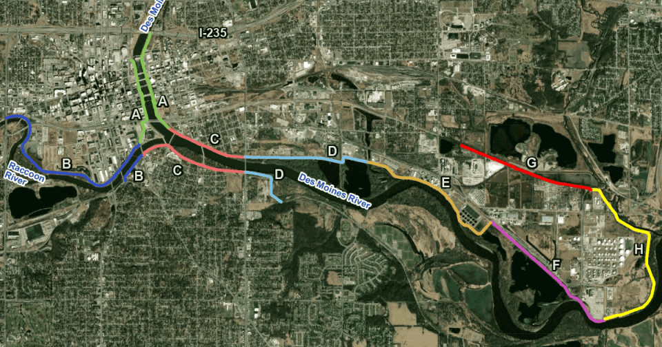
What are the projects?
Levee Alterations Phase A Project: Located along the Des Moines River downtown from the confluence with the Raccoon River to Center Street. Status: completed.
Levee Alterations Phase B Project: Located along the Raccoon River from the confluence with the Des Moines River upstream to Martin Luther King Jr. Parkway. Status: 85% complete.
Levee Alterations Phase C Project: Located along the Des Moines River from the confluence with the Raccoon River downstream to Southeast 14th Street. Status: started spring 2023.
Levee Alterations Phases D-H projects: Located on the Des Moines River downstream of Southeast 14th Street and including Fourmile Creek and its floodplain. About 4,000 feet of Phase G is being completed under the Southeast Connector project, which eventually will extend Martin Luther King Jr. Parkway from Southeast 30th Street to U.S. Highway 65. Status: design phase 30% complete.
Virginia Barreda is the Des Moines city government reporter for the Register. She can be reached at vbarreda@dmreg.com. Follow her on Twitter at @vbarreda2.
This article originally appeared on Des Moines Register: Des Moines looks to cut costs on its $100 million levee project

