Hurricane Kay to pound Mexico, unleash flooding in California


Hurricane warnings and watches were in effect for Mexico's Baja California peninsula Thursday as Hurricane Kay's outer bands began to impact the southern portions of the peninsula with winds and rain.
AccuWeather meteorologists say that the worst of the storm's impacts will be felt in Mexico, but the storm will still impact parts of the southwestern U.S. By the end of this week, Kay is expected to send moisture into Southern California, which could douse ongoing wildfires and raise the risk of flash flooding and mudslides in the region.
 |
Kay, which developed into a hurricane on Monday, has been delivering impacts to the Mexican coastline since this past weekend. With plenty of warm water at its disposal, as well as conducive atmospheric conditions, Kay became the eighth storm of the season to reach hurricane status in the East Pacific basin.
As of Thursday morning, Kay remained a large storm that had sustained winds of 85 mph (140 km/h), making it a Category 1 hurricane on the Saffir-Simpson Hurricane Wind Scale, and was moving north-northwest at 14 mph (22 km/h), according to the National Hurricane Center. Kay was located about 70 miles (115 km) west-southwest of Cabo San Lazaro, Mexico.
 |
While areas of heavy rain will continue in the western part of the Mexico mainland over the next few days, a greater concern is focused along the Baja Peninsula. It is along the Baja Peninsula, especially in the elevated terrain, where the heaviest rain is forecast to fall.
Widespread rainfall amounts of 4-8 inches (100-200 mm) are possible on the Baja Peninsula. Higher amounts of 8-16 inches (200-300 mm) can also occur for portions of the peninsula, with an AccuWeather Local StormMax™ of 20 inches (500 mm).
 |
"Flooding rainfall will be possible on the Baja Peninsula as the storm passes by. Damaging winds may also occur, capable of causing damage to structures as well as downing trees and power lines," AccuWeather Senior Meteorologist Alan Reppert explained, adding that hazardous seas and even a storm surge would be possible.
The impacts received will depend on the exact track the storm will take. A track that is more toward the east will bring the storm onshore faster, bringing greater impacts to a relatively small area, but causing it to rapidly lose wind intensity over land. This would spare locations farther north. Should the storm track toward the western edge, some of the worst impacts will remain far enough offshore of the Baja Peninsula.
As is typically the case with tropical systems, impacts can also extend far from the storm's center. In this case, tropical-storm-force winds will likely extend to 230 miles (370 km) from the center at times.
Due to the potential for flooding rainfall and wind damage, Kay is a 2 on the AccuWeather RealImpact™ Scale for Hurricanes in Mexico.
As the storm continues to track northward, cooler waters will quickly put an end to any strengthening, causing it to slowly lose wind intensity. However, should the storm remain offshore, but yet close enough for the coast to receive impacts, heavy rain and gusty winds may even spread as far north as Southern California at the end of the week.
 |
"The tropical system will be fighting off cooler waters and land interaction as it travels north toward the end of the week. Additionally, tropical systems have a tendency to curve away from the U.S. coastline over time. However, if the storm takes a very specific track, the door is open for impacts in California," AccuWeather Meteorologist Andrew Kienzle said.
Regardless of how far north the storm remains organized, an increase in tropical moisture may overspread much of the southwestern United States by the upcoming weekend. This moisture can bring an increase in showers and thunderstorms for some and provide relief from the area's ongoing heat wave.
 |
While tropical moisture can lead to a heightened risk of flash flooding in low-lying areas, any rainfall would also put a dent in the ongoing drought that the region faces. According to the U.S. Drought Monitor, drought conditions had engulfed the entirety of California and Nevada.
Kay is a 1 on the AccuWeather RealImpact™ Scale for Hurricanes in the U.S., mainly due to the potential for flash flooding.
An added impact from Kay and a strong area of high pressure over the interior West will be an increase in east to northeasterly winds from Friday to Saturday across Southern California. The setup could pose a problem for firefighting operations, especially if little or no rain falls due to dry air that the winds may bring.
"It is important to note that Kay will not be a hurricane by the time it gets close to California, but there still will be some gusty winds across Southern California as it moves by to the southwest," said AccuWeather Senior Meteorologist Brian Thompson. "The main concern regarding the wind is that areas that see gusty winds but not much rainfall may end up with a high fire threat, especially given the recent scorched vegetation with the recent heat wave."
On Friday, winds greater than 50 mph will precede Kay's rainfall over Southern California, especially over the mountains and through the canyons, according to AccuWeather Senior Meteorologist Bob Smerbeck. "This can fan wildfires prior to the arrival of Kay's rainfall Friday night and Saturday," he added.
The track Hurricane Kay is taking is unusual, but not unprecedented. No tropical storm has ever officially made landfall on the coast of California but dozens of rainstorms -- at one time considered tropical -- have affected the state.
 |
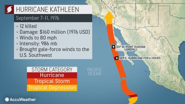
Hurricane Kathleen made landfall as a tropical storm in Baja California in September 1976, then the rainstorm moved into southern California, bringing record rainfall. |
The record rainfall associated with a tropical cyclone in California is 14.76 inches, recorded on San Gorgonio Mountain (80 miles east of Los Angeles) during Tropical Rainstorm Kathleen in 1976. Kathleen, once a hurricane that made landfall in Mexico's Baja California peninsula, tracked right through Southern California, pushing the core of the moisture from the storm right into the area. This will not be the same situation, as Kay is expected to remain offshore, passing southwest of the state.
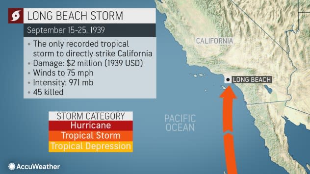
The worst tropical cyclone in California, colloquially referred to as "El Cordonazo" or "The Lash of St. Francis," made landfall in Los Angeles just under hurricane status in late September 1939, 11 years before official tropical storm tracking began for the East Pacific basin.
 |
Also known as "El Cordonazo," the Long Beach Storm of 1939 was a former-hurricane that made landfall at Long Beach, California, unleashing deadly flooding. |
That storm caused record rainfalls (at the time) for September at Los Angeles (5.24 inches) and Mt. Wilson, 20 miles northeast of L.A. (11.60 inches). The flooding killed 45 people. Residents were so unprepared for tropical storms that the U.S. Weather Bureau had to create a new office for Southern California which began operations the next year.
Want next-level safety, ad-free? Unlock advanced, hyperlocal severe weather alerts when you subscribe to Premium+ on the AccuWeather app. AccuWeather Alerts™ are prompted by our expert meteorologists who monitor and analyze dangerous weather risks 24/7 to keep you and your family safer.
