What did hottest September on record look like for Asheville?
ASHEVILLE - With the National Weather Service warning that Asheville could have seen record-high temperatures this summer, September ended up being a global record breaker.
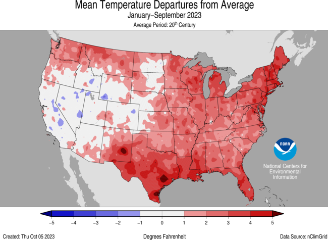
Last month was the hottest September globally, according to the World Meteorological Association. In America, the National Oceanic and Atmospheric Administration recorded September 2023 as the seventh-warmest September on record, with average temperatures 2.9 degrees above the 20th-century average.

William Angel, a management and program analyst at the National Centers for Environmental Information Asheville office, said that Buncombe County experienced a somewhat above-average September in terms of temperature, though it did experience a typical decline as temperatures cool heading into the fall season.
"Early on in the month, we were in record territory for the month, but as we transitioned, it turned out to be the 11th warmest September on record. Well below the record temperature that we observed in 2018," Angel said.
However, if current trends hold up there is a chance 2023 could finish out as a one of the warmest on record in Asheville, Angel said.
What are hottest Septembers in Asheville history?
While 2023 wasn't the hottest, it does come up when discussing the hottest Septembers in Asheville history, though places further down the line.
Here are the hottest Septembers the NCEI has on record for Asheville:
2018: 74.1 degree average.
2019: 73.6 degree average.
2016: 71.9 degree average.
1970: 71.8 degree average.
1998: 70.3 degree average.
1980: 70.2 degree average.
1978: 70 degree average.
1973: 69.9 degree average.
1971: 69.5 degree average.
2014: 69.3 degree average.
2023: 69.2 degree average.
What are the hottest years on record?
While this past September was not the hottest compared to other locations, 2023 is currently a scorcher for the area. The year hasn't ended yet, meaning that it cannot be included in a record of the hottest years in Asheville history, but recent years certainly show a foreboding trend.
Here are the hottest years on record for Asheville, according to data from NOAA:
2019: 59.1-degree year-round average.
2020: 58.5-degree year-round average.
2016: 58.4-degree year-round average.
2017: 58.4 degree year-round average.
2018: 58.2 degree year-round average.
Currently, without October, November and December being recorded, 2023 has a year-round average of being 61.2 degrees — similar to the 61.18-degree average temperature through September in 2020. The number is around a half-degree below the average at the same time in 2019, which is the hottest year in Asheville history.
Perfect fall foliage weather? Asheville fall foliage forecast: Cooling temps signal 'perfect conditions:' When is peak?
Upcoming eclipse? Will 'ring of fire' eclipse be visible in Asheville? What to know, where to get free glasses
Will 2023 be one of the hottest on record?
Angel said it is likely 2023 may end as a hotter year in Asheville history.
"Climatologically speaking for the next three months, there's really not a good clear signal on whether or not we're going to be above normal or below," Angel said. "But, if you take the average — yeah, Asheville will probably end in the top 10 of the warmest years on record."
As of this week, NOAA recorded nearly 60% of Buncombe to be "abnormally dry," with 1% of the county being in a moderate drought. As of Oct. 3, around 40.1% of the contiguous United States was in drought, up 5.8% from August, according to a NOAA press release.
Angel said this is common, though increased danger for fire may be cause for concern.
"Typically in the late summer months, and going through the fall, the Southeast tends to be drier than normal. That's our dry season," Angel said. "The biggest concern going forward is fire dangers, you know, with the leaves falling and everything else."
Last year, a late fall fire hit over 700 acres in the Pisgah National Forest.
What might this winter look like?
However, the drought may let up as this winter's El Niño could lead to more snowfall in the region — though, it's largely a matter of luck.
"You know, it's one of the strongest El Niños we have on record, and — what's the impact it's going to be here in the Asheville area? You know, typically for the Southeast, and for the Asheville area, we tend to be cooler than normal, with above normal precipitation," Angel said.
"And if you get the cold air in place, you tend to get more snowfall for the Asheville area. It's a matter of timing with these El Niño events."
An El Niño occurs when trade winds weaken on the Pacific Ocean and warmer water is pushed east, toward the west coast of the Americas, according to the National Ocean Service. The change can make areas in the northern U.S. dryer and areas along the Gulf Coast and Southeast experience more precipitation than usual.
More: Answer Man: Why can't people drive in the snow?
From 2022's Hurricane Izzy: Jim Cantore sighting; Izzy cancels most airport departures, arrivals
Will Hofmann is the Growth and Development Reporter for the Asheville Citizen Times, part of the USA Today Network. Got a tip? Email him at WHofmann@citizentimes.com.
This article originally appeared on Asheville Citizen Times: What did hottest September on record look like for Asheville?

