What’s the difference between sleet and freezing rain? Winter weather terms explained
North Carolina is expecting a taste of winter precipitation this weekend: snow in the mountains and a bit of freezing rain in much of the rest of the state before that turns to plain old rain, and plenty of it.
How are freezing rain and sleet different?
Our friends at the National Weather Service assure us we shouldn’t feel silly for asking this every time one or the other shows up in the forecast, because neither happens that often and either way, we’re running to the store for bread and milk.
But for the weather nerds among us:
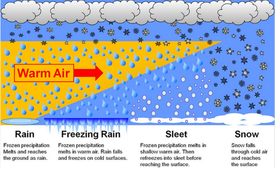
Meteorologists at the National Oceanic and Atmospheric Administration explain that freezing rain and sleet start out the same, as liquid raindrops in a layer of warm air in the atmosphere.
Both must fall through a layer of freezing-cold air on their way to the ground.
It’s the thickness of that layer of cold air that determines whether the precipitation lands as freezing rain or sleet.
▪ Freezing rain, NOAA says, happens when the layer of cold air is so thin the raindrops don’t have time to freeze before hitting the ground, but then freeze on contact, leaving a layer of ice where they land.
▪ Sleet hits the ground already frozen because it only happens when the layer of cold air is thick enough to turn the rain into ice during its vertical drop.
Which is worse?
They’re both bad for highway safety because they can make roads and especially bridges slick.
Freezing rain is more likely to accumulate on tree branches and power lines, weighing them down and causing them to break.

More winter weather terms
The National Weather Service, which has more words for frozen precipitation than North Carolina has barbecue recipes, notes the subtle differences this way:
Blizzard: A sustained wind or frequent gusts of 35 mph or more with enough falling or blowing snow that visibility is reduced to less than a quarter-mile, and these conditions will continue for at least three hours.
Blowing snow: Wind-driven snow that cuts visibility to less than 7 miles.
Drifting snow: Wind-driven snow that is unevenly distributed.
Drizzle: Rain, but smaller, with droplets of less than 0.5 millimeters in diameter.
Freezing drizzle: Droplets of less than 0.5 millimeters in diameter that reach the surface as liquid, then freeze when they land.
Freezing fog: Super-cooled water drops that freeze just after they wet the surface of the earth.
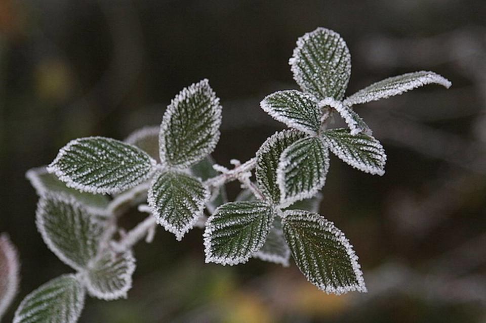
Frost: A thin layer of ice formed when water vapor lands onto a freezing surface, such as the grass in a low valley where temperatures on the ground are cooler than in the air just above it.
Graupel: Small hail, less than 5 millimeters.
Hail, soft and hard: If you slice it open, the Weather Service says, hail will have layers of soft and hard ice.
Soft hail forms when ice crystals, small super-cooled water and cloud droplets merge at below-freezing temperatures into balls at least 5 millimeters in diameter. Soft hail has air bubbles and appears more white than clear (like the chewy ice from a convenience store drink fountain).
Hard hail is more dense and happens when liquid water drops freeze on the outer edges of the hailstone after the outer edge is above freezing. (The freezing of super-cooled water releases latent heat and this can result in the outer edge of the hail stone warming above freezing. Then the water refreezes, creating ice.)
Ice crystals: these are small and float in the wind. Meteorologists sometimes call this “diamond dust.”
Mixed precipitation: A common part of the forecast when North Carolina gets a winter storm, this is a combination of two or more forms of winter precipitation occurring at the same time or over time in the same place.
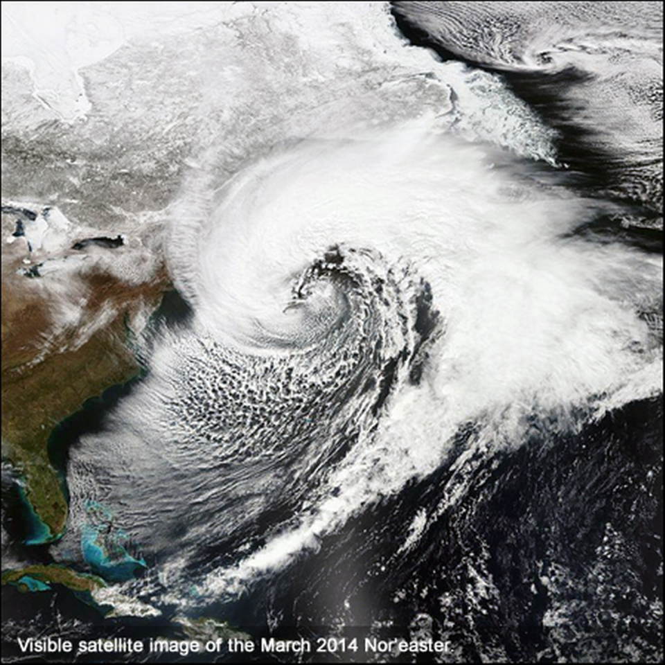
Nor’easter: A storm that usually forms along the East Coast between Georgia and New Jersey. They can happen anytime but are the most violent between September and April, and can bring heavy rain or snow and gale-force winds, rough seas and coastal flooding. The winds are typically from the northeast, giving the storms their name.
Rain: Liquid droplets that reach the surface at a size greater than 0.5 millimeters in diameter. Forecast in terms of light, moderate and heavy.
Rime: Interlocking ice crystals that accumulate on plants and other objects freely exposed to air when there is a heavy fog and temperatures are below freezing. Rime is white because it has air trapped inside.
Snow: Our favorite! An aggregate of ice crystals that form into flakes at temperatures below freezing. If it has to pass through layers of air that are above freezing, snow is less likely to reach the ground.
Snow grains: Small grains of ice, the solid equivalent of drizzle. These produce very little accumulation.
Snow pellets: These occur when ice crystals or snowflakes gather super-cooled water, or when snowflakes melt halfway and then refreeze on their way to the ground. Snow pellets can have characteristics of hail, sleet and snow, though they are whiter than sleet, and have air pockets inside.

