Disruptive snow squalls likely across southern Ontario this week
It’s going to be a rough couple of days for travellers across a swath of southern Ontario expecting heavy snowfall and low visibility as a multi-day lake-effect snow event shapes up.
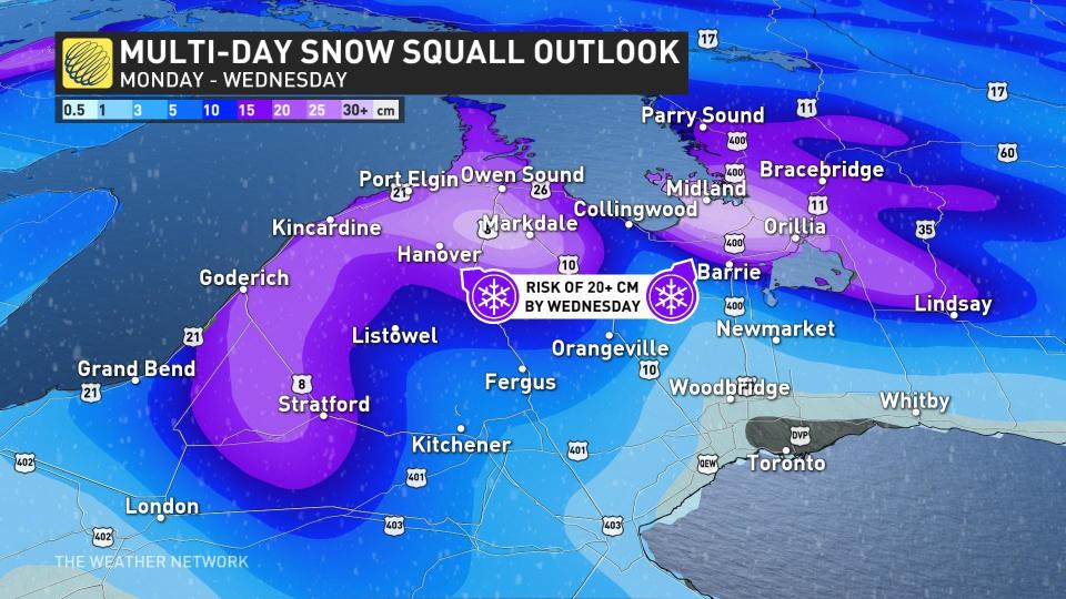
The coldest temperatures of the season will soon push into the region, setting the stage for wicked bands of snow to form over Lake Huron and Georgian Bay. Some areas could see more than 20 cm of snow by the middle of the week.
Prepare for significant travel issues and rapidly changing conditions over short distances.
DON'T MISS: Canada’s first -40°C reading a harbinger of a frigid week to come
Our weekend system that brought rain and snow to parts of southern Ontario kicked off the westerly flow that’ll allow cold air to spill in straight from the Far North.

A lobe of the polar vortex swooping over the Great Lakes will send temperatures plunging well below seasonal, creating the sharp temperature gradient needed for bountiful lake-effect snows to blow ashore on Monday, Tuesday, and even into Wednesday.
This setup will bring periods of heavy snow to communities downwind of Lake Huron and Georgian Bay, with the squalls meandering with shifting winds.
WATCH: What the GTA can expect from this week's snow squalls
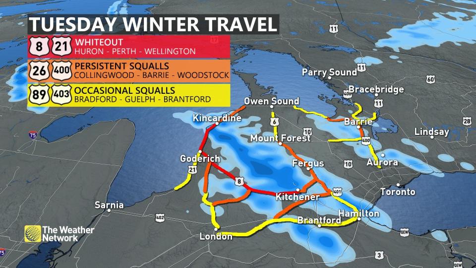
Westerly winds on Monday will focus the snow bands across Bruce and Grey Counties, inching toward Barrie, Orillia, and north toward Parry Sound in cottage country. Folks travelling Highways 6 and 21 through this region could encounter whiteout conditions on Monday.
BURIED: Why the Great Lakes produce some of the world’s heaviest snow
A wind shift will see prevailing winds from the northwest heading into Tuesday, allowing bands to flow southeast of the lakes. This will make for periods of extremely dangerous travel from Kincardine to Kitchener, with whiteouts possible along portions of Highways 8 and 21.
Persistent winds and cold temperatures could allow the feistier bands of lake-effect snow to creep into the Greater Toronto and Hamilton Area on Tuesday, with a risk for travel disruptions from occasional squalls between Hamilton and London.
SEE ALSO: What does a snowy fall mean for winter?
Widespread snowfall accumulations of 5-10 cm are expected outside of the Greater Toronto Area, with the hardest-hit areas in the traditional snowbelts possibly seeing more than 20 cm of snow on the ground by Wednesday.
It’s not just the snow we’ve got to worry about. This surge of cold air will bring the coldest day of the season to much of the region.
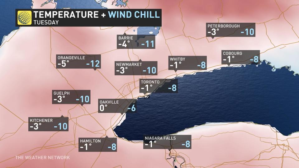
Toronto is looking at its first subfreezing day since early this year with a high of just -1°C in the forecast for Tuesday afternoon, with colder conditions just outside of the city. Wind chill values will easily dip into the double-digits below zero for many communities.
Things will start looking up once we get past Wednesday, thankfully. Milder air will push into southern Ontario for the opening days of December, bringing near or slightly above-seasonal temperatures and a chance for communities to melt off some of that fresh snow.
Stay with The Weather Network for all the latest on conditions across Ontario.

