Disruptive storm to produce life-threatening flooding, intense winds and snow in the West


An intense and impactful storm has moved onshore in California, ushering in rounds of soaking rainfall and mountain snow that is expected to persist into midweek.
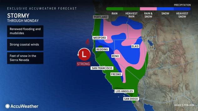
This storm will continue to be multifaceted in terms of threats and impacts, packing not only flooding rainfall, but also mountain snowfall that will be measured in feet. The expansive reach of this storm will mean impacts for at least five western states, with California expected to bear the brunt of the wind, rain and snow.
 |
A strengthening zone of low pressure advanced northward along the Central California coast through Sunday night, spreading a surge of moisture from the coast to interior regions of the West. The storm will progress slowly inland into and over the Southwest on Tuesday and Wednesday.
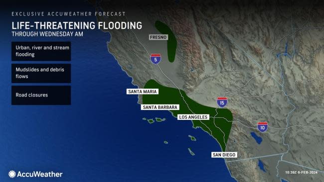
Forecasters warn that any residents within the impact zone from this powerful storm should be on alert for changing conditions and prepare based on their location for impacts ranging from flash flooding, landslides, travel disruptions, damaging winds, power outages to mountain snow. This storm will affect numerous population centers in the West, including Los Angeles, San Diego and Las Vegas.
"Public awareness and storm readiness are strongly encouraged as life-threatening conditions may evolve extremely fast in some communities," noted AccuWeather Senior Meteorologist Alex Sosnowski.
AccuWeather Senior Director of Forecasting Operations Dan DePodwin stated, "Roughly 94% of California's population, up to 37 million people, is at risk for life-threatening flooding. Due to the numerous mountains and hills, even just a few inches of rain can cause significant flooding. The greatest risk of a widespread flooding disaster is expected across the canyons and hills of Southern California, especially in Ventura, Santa Barbara and Los Angeles counties."
As the storm continues to barrel into the Golden State, rounds of heavy rain will expand from Northern California to Southern California. Saturday night, snow began to spread to the Klamath Mountains and the Sierra Nevada. Reports of hefty mountain snowfall totals began to pour in from Northern California on Sunday morning, with over a foot in 24 hours already observed in the higher terrain northwest of Lake Tahoe. Heavy snow has fallen on much of the Sierra Nevada since Saturday. Mammoth Mountain has reported over 3 feet of snow from the storm thus far as of Monday morning.
There have been numerous downed trees in towns and cities along the northern coastline throughout the daytime on Sunday. Trees have been knocked into power lines and onto cars in places like Mendocino, California.
The first-ever hurricane-force wind warning was issued for the state of California early Sunday morning, covering a corridor south of the San Francisco Bay area. Hurricane-force winds are categorized as winds exceeding 74 mph. There have been multiple reports of wind gusts between 100 and 150 mph over the summits of the Sierra Nevada. While the worst of the winds from the storm have already occurred, gusts frequenting 40-60 mph the central and southern parts of California can still trigger regional power outages.
Winds impacted much of the state of California, with gusts around the San Francisco Bay reaching 77 mph Sunday afternoon. Late Sunday night, power outages began to tally up around California, with roughly 657,000 customers experiencing outages, according to PowerOutage.US. That number has trickled down since the strongest winds began to ease on Monday.
Forecasters warn that the rounds of rain associated with this storm could be devastating for some locations and cause long-lasting issues with respect to travel disruptions, river levels and power outages. As this storm doubles down on the heavy rain that a storm brought to the region last Wednesday and Thursday, flooding conditions can quickly worsen with the soils already saturated and elevated streams and rivers.
 |
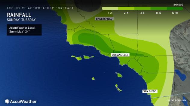
Soaking rainfall is expected to persist for most locations in Southern California through Tuesday. Locations surrounding the Los Angeles basin, the Central California coast and upslope regions west of the Sierra Nevada range could pick up 4-8 inches of rain.
"The San Bernardino Mountains outside of Los Angeles are projected to be a hot spot in terms of rainfall totals," explained AccuWeather Senior Meteorologist Adam Douty. As of daybreak Monday morning, storm rainfall of 8-10 inches has been reported at multiple locations along the mountains to the north of Los Angeles.
Douty added that general rainfall totals from Saturday night to Tuesday could soar to 12 inches or more across this mountainous region in Southern California with the AccuWeather Local StormMax™ of 24 inches.
 |
The intense rainfall over the upcoming days across parts of California can quickly lead to life-threatening flooding as urban, river and rapidly rising streams.
Road closures will be likely for locations along the coast, along the western edges of the mountain ranges and across the Sacramento Valley. Mudslides and debris flows will be a concern with the varying terrain across the state and deluge of heavy rain.
On Saturday, evacuation orders and warnings were issued due to heavy rainfall for numerous locations in Ventura County, California, according to the Ventura County Sheriff's Emergency Services Incident Dashboard.
Moisture expanded across the higher terrain of the Sierra Nevada and mountains surrounding the Los Angeles basin through Monday night, with between 3-6 feet of snow falling in places above 7,000 feet.
"For most passes around Southern California, snow will not be the threat. Snow levels will be around 6,000 feet during most of the duration of this event and transition to around 7,000 feet later Sunday and Sunday night. Heavy snow is expected to fall at resorts," explained AccuWeather Meteorologist Haley Taylor.
Taylor added that we will have to monitor conditions toward the end of this event, come Tuesday and Wednesday. Snow levels are expected to drop to around 5,000 feet, and some of the passes, like Tejon and Cajon Pass, could see some snow mixing in with rain Tuesday night. Currently, most of the moisture looks like it will be out of the region by then, so there shouldn't be major impacts at pass level.
In the mountains, blizzard conditions can develop as heavy snowfall combines with gusty winds upwards of 50 mph. Avalanche watches were put in place on Saturday across the slopes of the Sierra Nevada. Experts warn that the avalanche danger can rise to an extreme risk at all elevations by Sunday night.
 |
"Farther north, snow levels will be generally high through Tuesday, above 6,000 feet and even rising to 7,000 feet at times. For places above 7,000 feet, like Donner Pass, at least 2-4 feet of snow is expected through Tuesday. Places at lower elevations, like Truckee, California, at 5,804 feet, could see 1-2 feet. Along the westward-facing foothills of the Sierra, heavy rain is expected, and could lead to flash flooding," noted Taylor.
Events over the weekend in Los Angeles were affected by the storm, including the NASCAR Cup Series' Busch Light Clash and the 2024 Grammy Awards. The NASCAR Cup Series Clash race was moved from Sunday, Feb. 4, to Saturday, Feb. 3, due to the expected arrival times of wet conditions. The Grammy Awards saw the red carpet under cover this year, with umbrellas available to attendees, Grammy organizers reported.
Have the app? Unlock AccuWeather Alerts™ with Premium+
Over the upcoming days, rain and showers will begin to spread to places like Las Vegas, where the 58th Super Bowl will be hosted on Sunday, Feb. 11. Attendees are expected to flock to the city throughout the week, but those that arrive early may experience one of the wettest days in months.
U.S. desert cities like Las Vegas typically receive 0.83 of an inch of rainfall during the month of February. From Sunday to Tuesday, the city could observe between 1-2 inches of rain, over one months' worth. The rain that falls over the upcoming days may exceed what has occurred over the last four months combined. From Oct. 1, to Jan. 31, Las Vegas only observed 0.53 of an inch of rain.
Want next-level safety, ad-free? Unlock advanced, hyperlocal severe weather alerts when you subscribe to Premium+ on the AccuWeather app. AccuWeather Alerts™ are prompted by our expert meteorologists who monitor and analyze dangerous weather risks 24/7 to keep you and your family safer.
