There’s a new disturbance in the Atlantic. Grace is a hurricane and Henri will be soon
Forecasters are monitoring a new disturbance in the eastern Atlantic. They’re also watching the newly re-strengthened Hurricane Grace and Tropical Storm Henri, which is forecast to turn into a hurricane soon.
A Hurricane Henri could be the first one in 30 years to make a direct landfall in New England, the region of Maine, Vermont, New Hampshire, Massachusetts, Connecticut and Rhode Island.
Here’s what to know:
New disturbance in the Atlantic. Where is it going?
The new disturbance over the eastern Atlantic was producing a broad area of disorganized showers and thunderstorms several hundred miles to the southwest of the Cabo Verde Islands Friday mid-morning, according to the National Hurricane Center.
Forecasters expect the tropical wave will interact with another wave emerging off the African coast in the next few days before entering “marginally favorable” environmental conditions, which could lead to some slow development by early next week.
The system should gradually move to the northwest at 5 to 10 mph over the next several days. As of the 2 p.m. update it had a 0% chance of formation in the next 48 hours and a 20% chance in the next five days.
Will Henri break New England’s 30-year hurricane free streak?
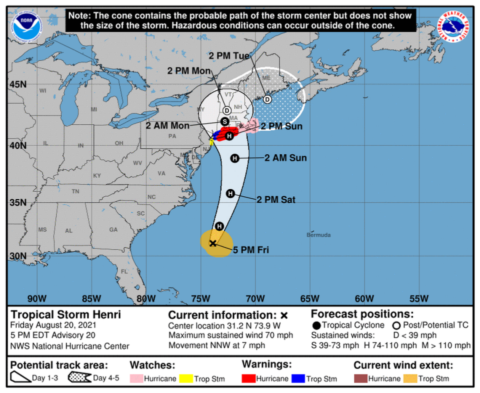
Tropical Storm Henri is still chugging along the Atlantic and is expected to become a Cat 1 hurricane by Saturday, according to the hurricane center. Parts of the northeastern United States are now under storm surge, tropical storm and hurricane watches, including Martha’s Vineyard.
Maximum sustained winds were near 70 mph with higher gusts, according to the hurricane center’s 5 p.m. Friday advisory. Tropical-storm-force winds extend out 115 miles from the center.
Henri slowed its west-northwest crawl to 7 mph and is expected to turn toward the northwest later Friday before another turn north. Its speed should pick up soon and the storm is forecast to approach the coast of southern New England on Sunday.
Forecasters are uncertain about Henri’s track and intensity, though nearly all of the models show the storm reaching the coast of southern New England.
The hurricane center expects Henri will quickly weaken once it slows over the colder waters south of New England. However, they say “it may not be quick enough to keep Henri from reaching the coast as a hurricane.”
If Henri retains hurricane strength and hits eastern New England, it would be the first hurricane to do so in 30 years. The last time? In 1991, when Hurricane Bob came ashore with 100 mph winds, according to CBS News.
Grace is a hurricane again. Forecast calls for another Mexico landfall
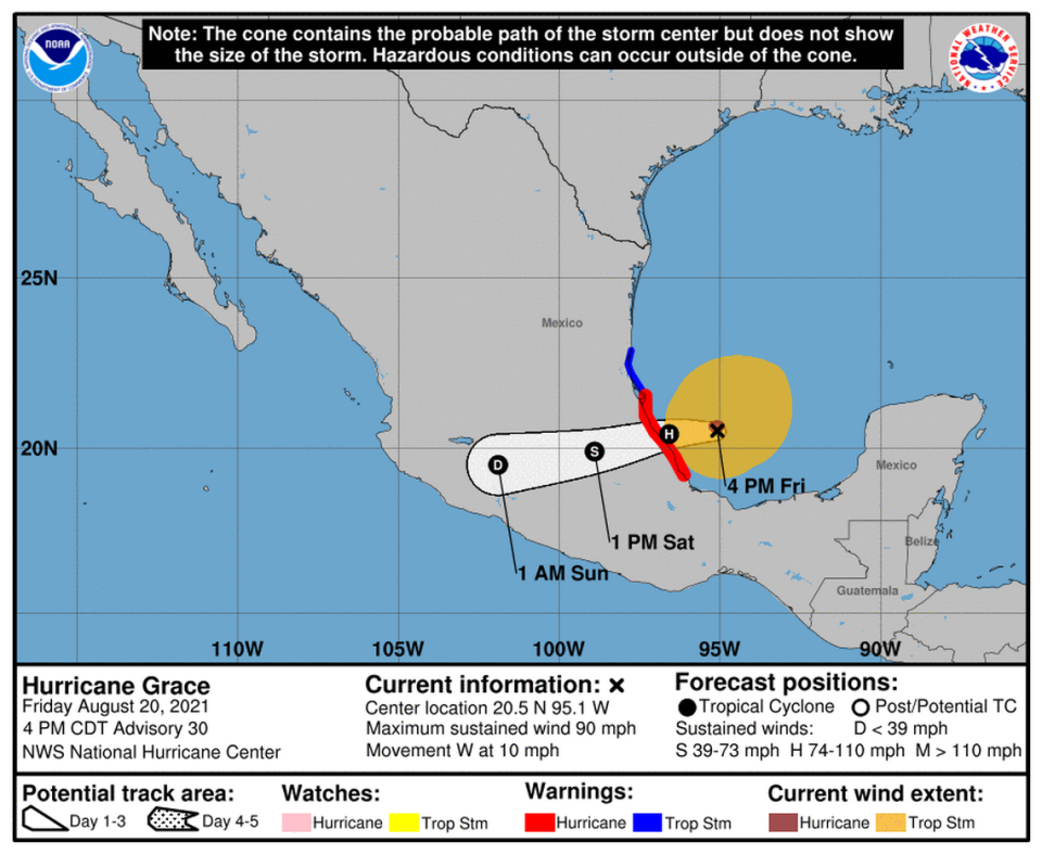
Grace regained hurricane status early Friday, and as of the 5 p.m. update the storm was headed across the Gulf of Mexico at 10 mph with maximum sustained winds of 90 mph with higher gusts. Tropical-storm-force winds extend up to 185 miles from its center and hurricane-force winds extend out 25 miles.
“Preparations to protect life and property should be rushed to completion” along the coast of mainland Mexico from Puerto Veracruz to Cabo Rojo, which are under a hurricane warning, according to the hurricane center. The coast of mainland Mexico from north of Cabo Rojo to Barra del Tordo is under a tropical storm warning.
On the forecast track, Grace should move across the southwestern Gulf of Mexico, where it should restrengthen into a hurricane again, before making landfall along the coast of mainland Mexico late Friday. It should then weaken rapidly as it moves inland into the mountains of central Mexico.
“The remnants of Grace are expected to move into the Pacific where they are likely to spawn a new tropical cyclone,” forecasters wrote.

