Has Charlotte’s tree loss stalled since 2018? Study says yes, but critics are skeptical
When city council members heard last month that Charlotte’s latest study said tree loss had basically flatlined, some board members were gleeful if surprised.
“This is really good news…” said councilwoman Dimple Ajmera. “I wasn’t expecting to hear that. So, you just made my day.”
But is it true?
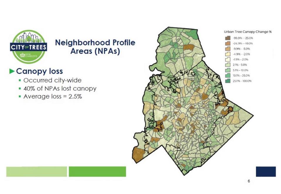
The canopy count, performed by the consulting firm PlanIT Geo and released on Nov. 13, found that Charlotte lost 969 acres of trees – or .5% of its canopy from 2018 to 2022. Canopy still covers 47.3% of The City of Trees, the study said.
And although the canopy decreased slightly, the city’s long-held goal of reaching 50% canopy coverage by 2050 could still be possible, according to the assessment. That is, if the city plants tens of thousands of trees annually to keep up with ones lost to development.
But a count that used gold-standard technology found that the city’s canopy was only 45% back in 2018. And skeptics of the new count say it could distort the need for stricter tree-preserving rules.
Five GIS experts told The Observer that the recent assessment’s results might not be as accurate as that 2018 review, which calculated that the city was losing three football fields of trees each day.
Doug Shoemaker, a UNC Charlotte ecologist and GIS specialist who has studied Charlotte’s canopy for years, is especially critical. The conclusion in the new analysis “flies in the face of what we know anecdotally,” he said.
“It’s pretty easy to go out and see dramatic canopy loss,” Shoemaker said.
Tim Porter, Charlotte’s chief urban forester, acknowledged the discrepancy in an interview.
“Given the results of the previous analysis, there was some surprise that this was not showing the same decline trend,” Porter told The Charlotte Observer.
He and a co-worker didn’t mention the 2018 study at last month’s meeting due to time constraints, he said. City council members will receive a more detailed briefing, which will include a look at the previous analysis, he said.
The science of counting trees
Experts’ concerns with the new count stem from the way PlanIT Geo measured willow oaks, tulip poplars, pines and other trees standing across the city. The Colorado-based company used National Agriculture Imagery Program data – aerial images – and machine learning to map the canopy change from 2018 to 2022.
The U.S. Department of Agriculture’s data is good for detecting trees, the experts said, but measuring an entire canopy is difficult. And imagery alone has a hard time differentiating a tree from a bush or detecting a tree in the shadow of a building.
“It’s like when you look at Google,” said Michael Galvin, director of SavATree Consulting Group, which inventories canopies nationwide. “It’s a picture from the top down. It’s good, but when you’re looking at that, it’s not great telling a tree from a mature tree, from a shrub, from grass.”
The best approaches, Galvin said, use a combination of imagery, which distinguishes colors, and Light Detection and Ranging – or LiDAR – which very precisely measures the heights of objects.
PlanIT Geo’s report acknowledged that using LiDAR could be a great option, “but this is more difficult and expensive to obtain.”
Andy Evans, GIS manager for PlanIT Geo, defended its approach, saying in an email that the company’s machine learning models are trained using LiDAR and imagery.
“Once the model is trained, we can produce LiDAR-like results by feeding imagery into the model,” Evans wrote. “Also, there are problems with the availability of LiDAR. LiDAR data is often difficult to find, and it may or may not be available for the year that is being assessed. LiDAR data becomes less and less helpful at improving results the further away it is in time from the imagery being used.”
LiDAR data is created when a laser mounted on an aircraft scans the ground. The time it takes for the laser pulses to hit an object and bounce back to the scanner allows researchers to calculate the object’s height, according to the U.S. Department of the Interior, which scans the entire country every few years.
Experts told the Observer that LiDAR can bypass problems that clouds, shadows, fog and angles cause imagery.
“You can create a 3-D presentation,” said Daniel McCraine, research engineer for the Geosystems Research Institute at Mississippi State University. “You can look at it not only from top down, but you can look at it from a profile view, like you were on the street. It definitely would give you a more rounded picture of what’s going on. And more information is typically better when it comes to making a decision.”
PlanIT Geo’s second count
This isn’t the first time PlanIT Geo produced a crowd-pleasing assessment of Charlotte’s canopy.
It also measured the city’s tree coverage from 2012 to 2016, finding that Charlotte’s canopy remained unchanged, possibly dropping about .3% to 46.8%.
Given a 1.2% margin of error, Charlotte may have actually gained trees in the four-year span, according to that count.
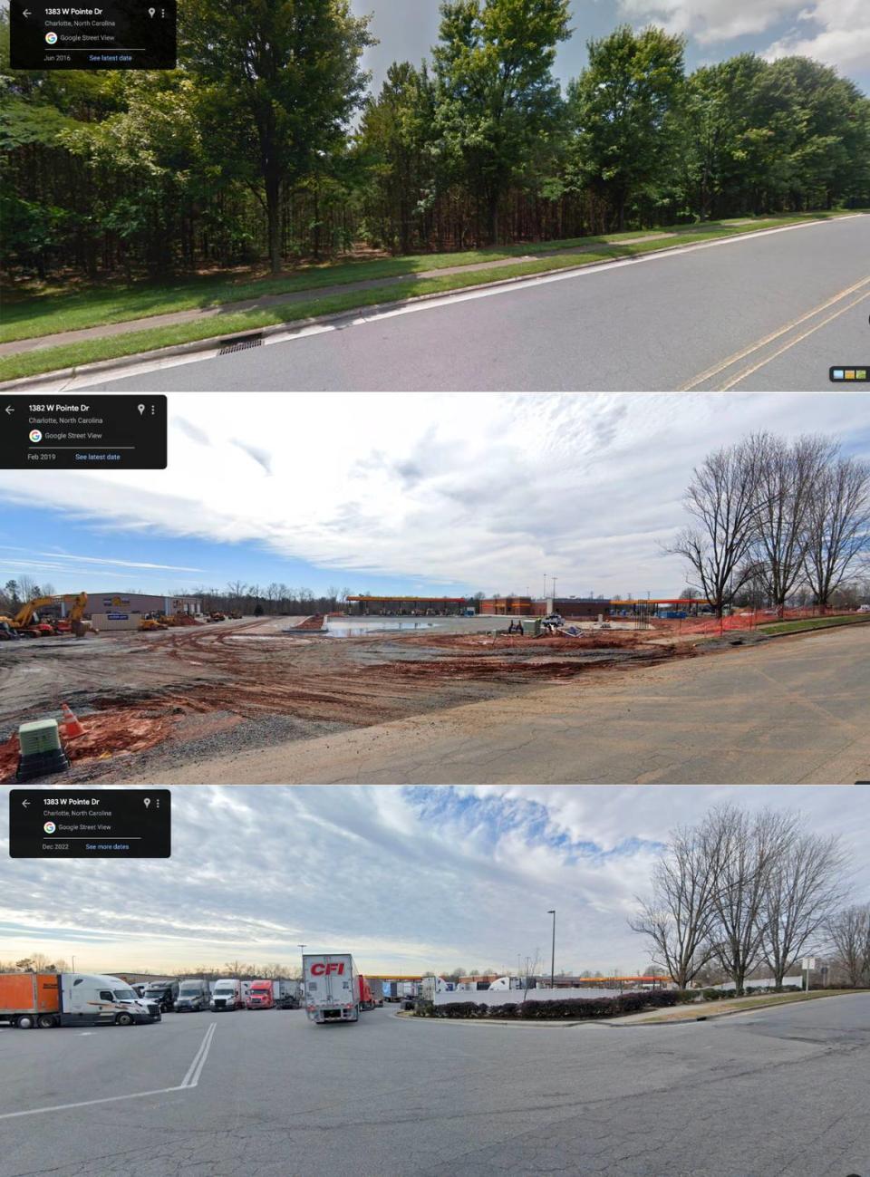
But Chuck Cole, who led the nonprofit TreesCharlotte at the time of the assessment, and others were skeptical. How could the city’s canopy be stable when he saw trees being toppled all across town, Cole wondered.
“I was not convinced that these were accurate numbers, and I needed more information,” Cole told The Observer. “The information that they gave me did not have enough detail for me to actually make any kind of planning - where to improve, how to improve, where we might be.”
So, TreesCharlotte paid $8,800 for its own assessment, this one done by the University of Vermont’s Spatial Analysis Lab, a lab that previously measured the city’s trees.
Jarlath O’Neil-Dunne, a canopy-mapping specialist, led Vermont’s analysis. He used imagery and LiDAR data and concluded that Charlotte’s canopy was not stable. In fact, it dropped from 49% to 45% from 2012 to 2018, the study found.
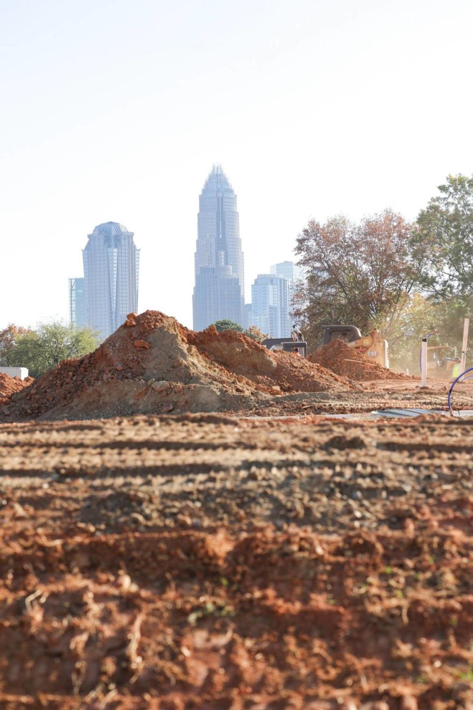
The loss that O’Neill-Dunne measured equaled about three football fields worth of trees every day for a six-year period, or 7,669 acres overall, he reported.
Most of the loss happened on residential properties. And most of the missing trees were of “middle height,” indicating that they were taken down rather than dying of old age.
PlanIT Geo’s recent assessment also found that most trees were removed on residential land. But its findings were much rosier and “less precise and less accurate,” O’Neil-Dunne said.
“This is not a bad assessment,” said O’Neil-Dunne of PlanIT Geo’s new report. “But it depends on how you use it… I wouldn’t draw any conclusions on whether the city’s overall tree canopy is increasing or decreasing.”
The new study and additional services from PlanIT Geo cost $115,000, with the city contributing about $15,000 and TreesCharlotte covering the rest, said Porter, the city’s chief urban forester.
In addition to the new count, PlanIT Geo will provide an interactive tool that will help the city map its planting and preservation efforts, as well as Charlotte’s urban heat islands.
Residents will be able to use the online tool beginning early next year, Porter said, adding that he trusts the new assessment.
PlanIT Geo specialists performed quality control checks on the data, spot-checked their findings with point samples and found some of the same trends that Vermont found, Evans said.
“We have full confidence in the quality of the canopy data provided to the City and TreesCharlotte for this assessment,” Evans wrote.
Data needed for policy change
Shoemaker, the UNC Charlotte ecologist, said he fears that an incorrect canopy measurement could lead city officials to adopt less rigorous tree-protecting policies.
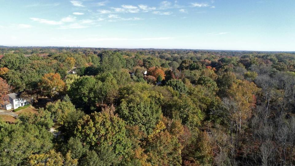
That could be a problem for residents. Trees just aren’t nice to look at. Living near them reduces stress, improves mental health, student performance and worker productivity, research says.
Their roots slow runoff, and their leaves absorb carbon dioxide, a greenhouse gas. Their shade provides needed relief in hot summers.
Understanding where they stand is vital, Shoemaker said.
“An ordinance like the tree ordinance is done on a parcel-by-parcel level. And when you’re trying to manage trees at that grain, this data becomes not very useful,” he said of the new study.
Jane Myers, TreesCharlotte’s executive director, said she trusts the new count. Although residents notice the clear-cutting, the study picked up areas of new canopy growth that often get overlooked, Myers wrote in an email to The Observer.
Still, she said, the city needs to plant more trees.
“We know we need to get more aggressive with our efforts to maintain Charlotte’s iconic urban forest for Charlotteans in the years to come,” Myers wrote.
PlanIT Geo’s method found that although the canopy is still decreasing, hitting a 50% coverage by 2050 is possible. But increasing the canopy would require planting thousands of trees and possibly strengthening the city’s tree-saving policies, Porter said.
Porter said city officials would use the new counts to help shape those recommendations.

