Double rounds of soaking rain, severe thunderstorms to sock Southeast into this week

Rain gear will be in vogue across a large swath of the southern and eastern United States into this week as a pair of storms will deliver a couple of rounds of soaking rain and even a few severe thunderstorms, warn AccuWeather meteorologists.
For some, the amount of rain expected from both storms will be too much too quickly, and flooding will occur. The rain will be welcome news for many due to long-standing drought conditions. Meanwhile, the powerful nature of the storms, which will also lead to episodes of travel-snarling snow and ice in the Northeast and in the Midwest, means that thunderstorms that develop in the South could pack a punch and even spawn tornadoes.
 |
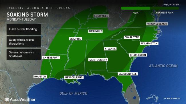
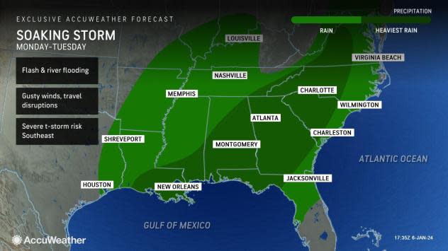
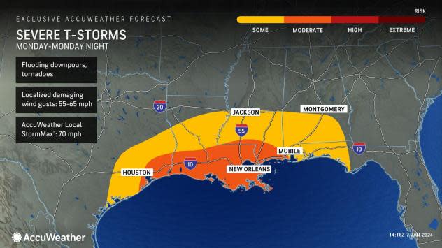
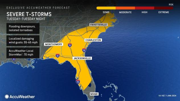
"A severe weather and tornado outbreak is very possible from Monday to Tuesday, from Houston to Fayetteville, North Carolina," Extreme Meteorologist and Storm Chaser Reed Timmer, Ph.D. said.
An initial round of heavy rain and thunderstorms from the first storm continued to progress across the Southeast states on Saturday.
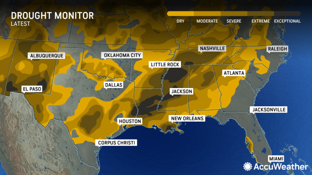
Rainfall amounts on the order of 0.50 of an inch to 2 inches have been common across the South, with this area overlapping some of the worst drought conditions in the region, especially across Louisiana and Mississippi. According to the latest U.S. Drought Monitor released on Thursday, large portions of both states are experiencing extreme to exceptional drought conditions, the two most dire categories.
 |
A few thunderstorms turned severe as they pushed southward across the Florida Peninsula into Saturday night, including one that spawned a tornado in Fort Lauderdale, Florida.
Following the soaking rain and thunderstorms, building high pressure from the west will bring a break in the rain and a return to sunshine for about a day from Sunday and into Monday for most.
 |
"Sunday will be much improved for outdoor plans," added Pydynowski. "For the football game between Carolina and Tampa Bay in Charlotte, North Carolina, it will be dry and in the 50s." However, not long after this dry weather arrives, the next storm will already be warming up on the sidelines.
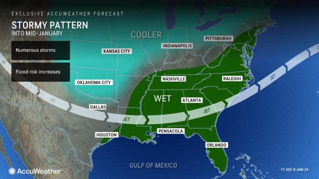
AccuWeather meteorologists are warning that the next round expected to move through with the storm this week could pack even heavier rain and stronger storms over a larger area.
"The ingredients coming together early next week will set the stage for what could be the largest storm of the winter season so far," said AccuWeather Senior Meteorologist Tyler Roys.
After impacting the West this weekend, the new storm will arrive in the southern Plains late Sunday night and early Monday, begin to pick up strength and copious amounts of moisture from the Gulf of Mexico and douse the South into Tuesday.
 |
On top of the inch or two of rain expected into this weekend, another 2-4 inches is possible from the Texas Gulf Coast near Houston to the mid-Atlantic coast early next week. In many areas, water from the first storm that filled up some smaller creeks and streams may not have had time to recede, resulting in more widespread flooding issues with the second storm.
Some places may record more than 6 inches of rain from the storms spanning this past Friday to Tuesday.
The rain could result in widespread disruptions to highway commutes as well as airport delays due to poor visibility and low cloud ceilings during the heaviest episodes of rain and thunderstorms.
The severe weather threat with the second storm will be higher than the first, Roys warned. "While the most widespread risk to lives and property will likely be flooding rainfall, some of the most intense thunderstorms can feature damaging wind gusts and a few tornadoes," he explained.
 |
On Monday, the threat of severe thunderstorms will extend from eastern Texas to southwestern Georgia. By Tuesday, it will stretch from the Florida Panhandle to eastern North Carolina. Besides the threat of flooding and a few tornadoes, the most intense thunderstorms can feature wind gusts that can approach the AccuWeather Local StormMax™ of 70 mph.
There will also be a wintry side to the second storm with heavy snow and blizzard conditions expected to unfold from the central Plains to the Midwest.
Want next-level safety, ad-free? Unlock advanced, hyperlocal severe weather alerts when you subscribe to Premium+ on the AccuWeather app. AccuWeather Alerts™ are prompted by our expert meteorologists who monitor and analyze dangerous weather risks 24/7 to keep you and your family safer.
