New downtown Milwaukee plan includes a focus on removing I-794 and a renewed MacArthur Square.
Interstate 794's barrier between downtown Milwaukee's east side, the lakefront and the Historic Third Ward should be reimagined, with a focus on planning its eventual replacement with at-grade streets, according to a new city proposal.
Meanwhile, MacArthur Square − a longtime dead zone east of the Milwaukee County Courthouse − will get a another redevelopment push with the adjacent Milwaukee Public Museum planning its 2026 move.
Both are part of Milwaukee's new downtown comprehensive plan, proposed by Mayor Cavalier Johnson's Department of City Development. That plan, last updated in 2010, includes such goals as growing downtown’s population; investing in parks and other gathering spaces; expanding and enhancing transit; reconnecting places divided by barriers; improving streets to support all users, and redesigning streets as public places.
Known as “Connec+ing MKE – Downtown Plan 2040,” the plan has been the subject of a series of open houses during the drafting process.
A final open house is scheduled for May 11, from 3:30 p.m. to 6:30 p.m. at 3rd Street Market Hall, 275 W. Wisconsin Ave., before it undergoes Plan Commission and Common Council review this summer. Also, people can provide feedback until May 22 at www.connectingmke.com.
Past downtown plans, like the current update, have included several areas which city development officials and others envisioned as catalytic development sites.
In some cases, such as the conversion of the former Grand Avenue mall into The Avenue mixed-use development, those visions have become reality. Other sites, such as MacArthur Square, remain on the to-do list.
Here's a look at the seven catalytic sites included in the updated plan.
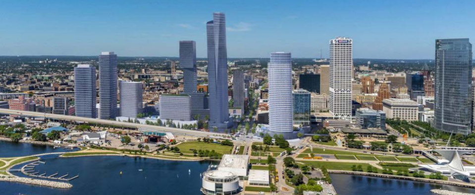
I-794 replacement with at-grade streets
The possible replacement of I-794 with at-grade streets will depend on what the Wisconsin Department of Transportation decides to do.
DOT has proposed spending $300 million to replace different pieces of I-794 on the freeway's eastern portion, including on- and off-ramps tied to the Hoan Bridge. Construction is tentatively set to run from 2025 through 2028, with public meetings on that proposal to start this year, and the project's design stage to be finalized in 2024 and 2025.
The freeway portions to be replaced date to 1974. They were not touched when part of I-794 east of the Milwaukee River was reconstructed from 2013 through 2016 — a $239 million project that included rebuilding the Hoan's concrete deck.
A campaign led by 1,000 Friends of Wisconsin, a Madison-based nonprofit environmental advocacy group, hopes to persuade the DOT to instead replace I-794 with a surface boulevard.
Those advocates say 32.5 acres that now lie fallow beneath the elevated I-794 between the Hoan Bridge and North Sixth Street could be eventually developed as apartments, offices and other buildings with estimated values totaling $1.5 billion.
The city's plan calls for a focus on eventually removing I-794.
It also says that if removal is not feasible "any interim alternative should prioritize modernization of the infrastructure to reduce the footprint, activation of the public spaces and streets under the bridges, improvements to the ramp connections, and increase safety for pedestrian crossings."
That could include commercial real estate broker Bruce Westling's idea to remove two freeway ramps between the Milwaukee River and the Hoan Bridge.
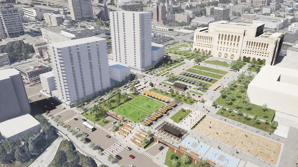
MacArthur Square area redevelopment
Both the 1999 and 2010 downtown plans recommended extending extending a stretch of West Kilbourn Avenue from its current end, at North Sixth Street, to North Lovell Street.
That would help end the isolation of the 9-acre MacArthur Square. It was cut off from downtown in 1967 with the construction of the parking garage beneath it, and the tunnels to and from I-43.
The updated plan again calls for extending the street grid to the square − an expensive project. That would help support development on nearby parking lots as well a redevelopment of a nine-story, 201,200-square-foot state office building, at 819 N. Sixth St., the plan said.
The state Department of Administration plans to seek buyers for the Sixth Street property after a new state office building is eventually developed south of West Wisconsin Avenue and west of North 27th Street.
Also, the Milwaukee Public Museum site, 800 W. Wells St., "should be redeveloped with high-density mixed-use development with a goal of including mixed income housing and neighborhood supporting commercial uses on the ground floor," the plan said.
The new museum is to open in 2026 at West McKinley Avenue and North Sixth Street.
Water Street entertainment district
A redesigned North Water Street could feature fewer lanes for cars, wider sidewalks, protected bike lanes and transit improvements − making the street safer for everyone.
"Street improvements will also help spur development along the Water Street corridor, which includes a number of priority redevelopment sites with the potential to add significant new development," the plan said.
Some of the planning for Water Street has already started, with improvements to be funded through tax incremental financing districts.
That's part of the city's Complete Streets strategy that calls for traffic calming measures to help reduce reckless driving and boost development.
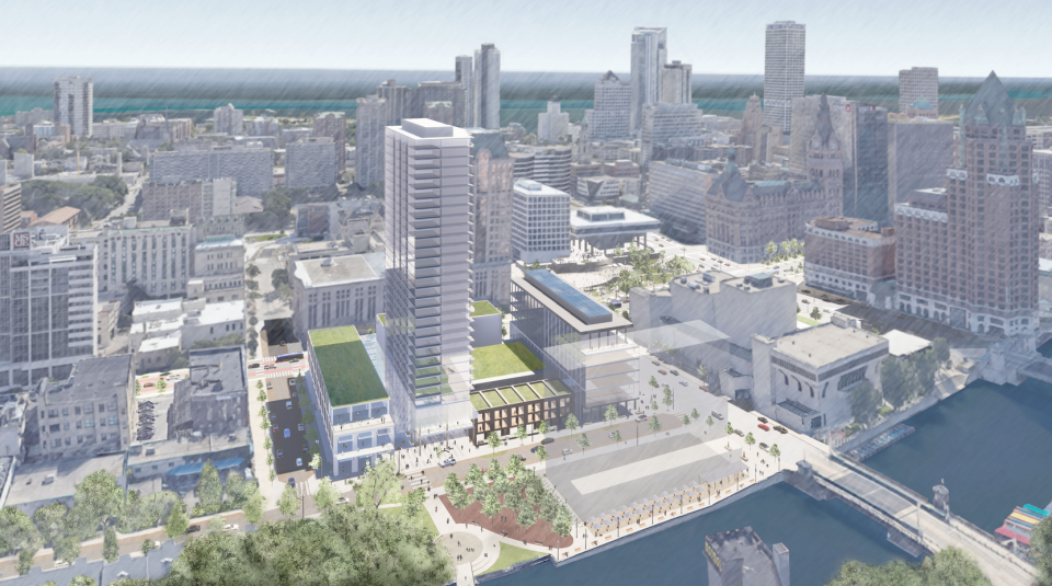
Marcus Performing Arts Center parking garage redevelopment
The Marcus Performing Arts Center parking garage, which covers 2.5 acres at a key downtown site, is to again be targeted for a potential redevelopment.
It should be "replaced with new high-density mixed-use development that adds density and vibrancy to the district. This could spur the development of underutilized sites in the area including surface parking lots along Water Street and the RiverWalk," the plan said.
The 53-year-old parking structure is owned by the city and leased to Marcus Center for the Performing Arts Inc., a private, nonprofit corporation.
It was built during a period when parking structures often didn't include ground-level retail space − now considered an important tactic for activating the area.
Public space management organization
A new organization could help manage and help fund public spaces such as Cathedral Square, Red Arrow and Pere Marquette parks.
"After initial upfront investments are made in parks, the most successful urban parks remain active with an abundance of free and inclusive activities designed to users of all ages and races, improving the ability of Downtown parks to be gathering spaces for ALL Milwaukeeans," the plan said.
That organization could take the form of a nonprofit friends group, such as the one which helped lead recent improvements at Cathedral Square − where more changes are envisioned.
Another possible model would be a neighborhood improvement district. Such a district would have the power to levy special assessments on downtown properties.
Sixth Street reimagined as a complete street
A redesigned Sixth Street to focus more on transit and bikes would better connect downtown to both north and south side neighborhoods.
It would build on the momentum generated by the relocated Milwaukee Public Museum by making it more accessible and spur adjacent private development, the plan said.
The redesigned street also would "embody the vision" of a connected downtown linking to such destinations as Bronzeville, Halyard Park, Hillside Terrace, Milwaukee Area Technical College, the Brewery District, the Deer District, the expanding Baird Center convention facility, West Wisconsin Avenue, the Iron District and Walker’s Point.
The Hop streetcar extensions
Efforts to expand The Hop have focused on proposed connections to King Drive and the Bronzeville area north of downtown and Walker’s Point south of downtown − which could help attract commercial development, the plan said.
"The City should continue to pursue these planned and future streetcar extensions, and work aggressively to secure funding and support for these extensions," it said.
The city has been unable obtain federal grants for extending The Hop while it continues to await completion of its delayed lakefront loop tied to the Couture apartment high-rise construction.
More: Renderings show Milwaukee's proposed changes to the selected downtown areas
Tom Daykin can be emailed at tdaykin@jrn.com and followed on Instagram, Twitter and Facebook.
Our subscribers make this reporting possible. Please consider supporting local journalism by subscribing to the Journal Sentinel at jsonline.com/deal.
DOWNLOAD THE APP: Get the latest news, sports and more
Subscribe to get the BusinessWatch email newsletter.

This article originally appeared on Milwaukee Journal Sentinel: New downtown Milwaukee plan includes a focus on removing I-794
