Epic temperature plunge, snow squalls in Ontario to follow winter thunderstorms
From record-breaking spring-like warmth and thunderstorms, to a fast and steady temperature drop and the threat of a flash freeze — the weather across southern Ontario this week will certainly have it all.
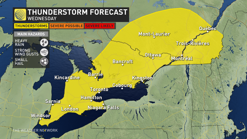
Thunderstorms crept into the region on Tuesday afternoon, as temperatures soared well above seasonal once again, along with periods of heavy rain and even small hail -- something that is certainly an uncommon feature for the month of February.
A drastic temperature change will soon put an end to the warmth, bringing with it the chance of a flash and hard freeze, depending on the locale, with values plummeting by as much as 20 degrees in a short amount of time. To add to that, a round of snow and potent squalls will follow suit for some.
RELATED: Rare winter hail pelts southern Ontario communities
Drivers are being urged to plan ahead, and to adapt to the rapidly changing conditions over the next couple of days.
Wednesday: Threat for a flash or hard freeze after a record-setting warm start to the week
After a warm and above seasonal Monday, temperatures increased further on Tuesday across all of southern and eastern Ontario.
Windsor became the first place in Ontario this year to reach the 20°C mark on Tuesday afternoon! Temperatures reached 21.4°C in Windsor, beating the city's previous record February high of 20.4°C set in 2000.
Sarnia also broke its own record high for February on Tuesday, with temperatures climbing to 20.7°C -- beating out the previous record of 19.4°C, also set in 2000.
Thunderstorms were reported in the Bruce Peninsula early in the day, with more reported later around Hamilton, Oakville, and Niagara. Near quarter-sized hail was also reported in London ahead of the lunch hour as the storms bubbled up.
DON’T MISS: Earth just experienced its hottest 12 months in recorded history
MUST WATCH: Hail, not snow, piles up in Ontario during rare February thunderstorm
Wednesday is when things take a tumble, and fast, too.
The region will see a potent cold front push in, with a razor-thin line separating a snowstorm in the north and another potentially record-breaking warm, stormy day in the south.
On Wednesday morning, the GTA and eastern Ontario, with Ottawa included, will likely see heavy rainfall to start the day and possible rumbles in the air, too. However, the day will end on a polar opposite note.
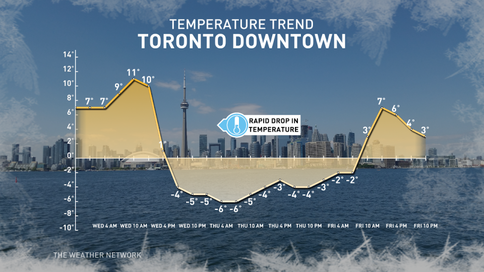
Forecasters are concerned for a flash-freeze event with any standing water from Tuesday's thunderstorms turning to ice. The GTA and central Ontario could see a drastic drop from the unseasonably warm temperatures to freezing negative temperatures in only a few hours. This will result in surfaces becoming slippery rather quickly. Any plans to travel during this time will likely need to be postponed.
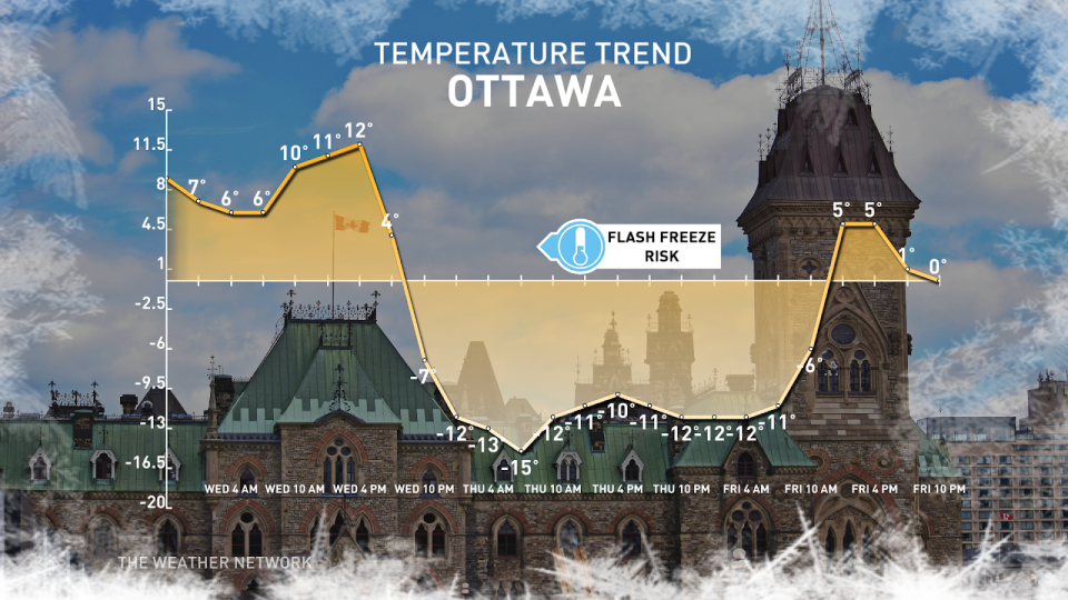
Eastern Ontario will see the same dramatic temperature drop Wednesday evening. Ottawa’s high of 13°C during the day Wednesday will turn on its head to a brutal low of -14°C by the overnight period.
Overall, a temperature drop of 20-25°C is expected to take place over an approximate eight hours Wednesday evening and into Thursday's early morning hours.
MUST SEE: How global warming is reshaping winter life in Canada
In addition, temperature swings such as these will come in with a roar and make themselves known. Gusty winds between 60-80 km/h are a concern across southern and eastern Ontario Wednesday evening, with bitterly cold wind chill values present.
After temperatures plunge, precipitation will quickly change over to bursts of snow, including a super snow squall off of Lake Superior, stretching over 1,000 kilometres long, deep into New York into the day on Thursday. Travel will be near impossible within the snow squall, with 60+ km/h winds and snowfall rates near 3 cm/h.
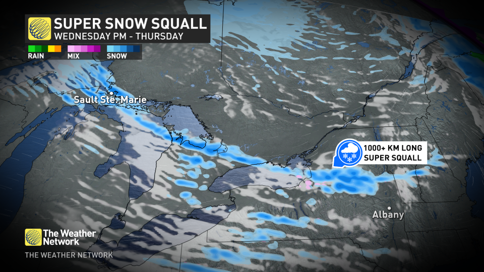
A narrow band of intense winter weather will cause havoc on the roads Thursday morning for the Bruce Peninsula, Barrie region, sections of the 400 and 401 east of Toronto. Drivers are strongly urged to consider postponing travel during this time.
Temperatures are expected to quickly rebound across southern and eastern Ontario heading into the weekend.
Stay with The Weather Network for all the latest on your forecast across Ontario.
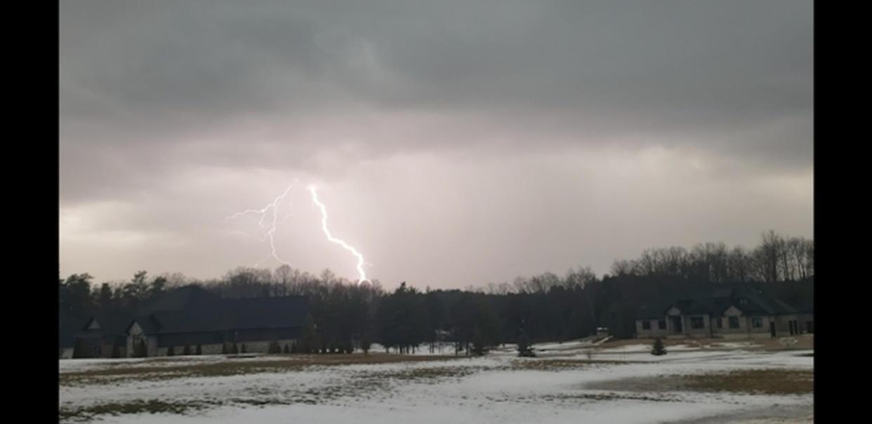
Thumbnail image of a lightning strike from the thunderstorms on February 27, 2024 taken and submitted by Cassie S. in Durham, ON.

