Drenching rains and lashing winds on tap for East Coast. Will Hilton Head be hit?
The Lowcountry is not out of the clear as a strong low-pressure system will push its way from the Gulf Coast, sending drenching rains and lashing winds along the Eastern Seaboard this weekend.
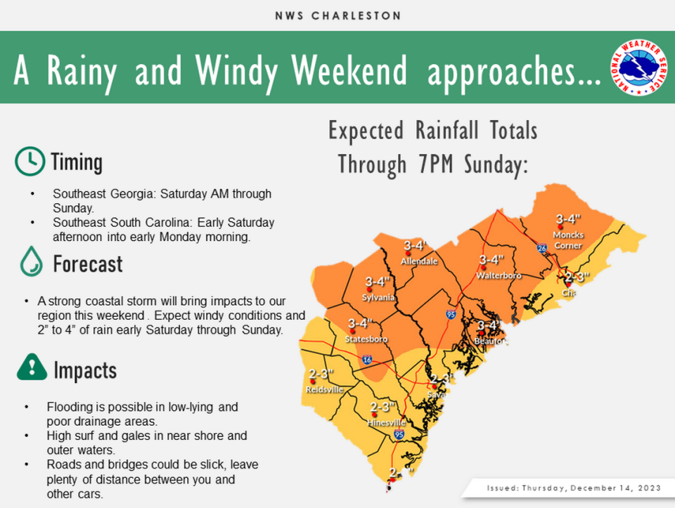
Beginning Saturday afternoon, rain and coastal wind will whip up in the Lowcountry, and the effects will linger into Monday morning, according to the National Weather Service’s Charleston Office.
NWS meteorologist Michael Stroz said impacts to the Lowcountry will depend on the storm’s track and timing. As models become clearer, the storm looks like it will track to the northeast, paralleling the coastline. Stroz said the Lowcountry will see the majority of effects starting late Saturday and lasting through Sunday evening.
“Sunday will be a rather ugly weather day for us,” said Frank Strait, the state’s severe weather liaison. “Travel conditions will be awful due to wet roads and strong winds; I recommend staying home if you can.”
Beaufort County could get pelted with rain that totals between 3 and 4 inches. Local amounts could be higher, the service added. Low-lying areas and those with poor drainage will be particularly vulnerable, and roads and bridges may be slippery. Because of the rate of rain over time, Stroz said there is little likelihood that flash flooding will occur.
On Friday, the uncertainty of the storm’s track meant impacts from coastal flooding weren’t immediately clear, Strait said.
The storm will pass close to the coast, he said, but it could track just inland or offshore. The further offshore the storm center passes, onshore wind will be less significant. That would lead to a decreased coastal flooding risk during Sunday morning’s high tide. But, if it tracks over land, the longer period of onshore winds whipping through would increase flooding risk.
Rain accumulation doesn’t account for its interaction with high tides. In Beaufort, Saturday and Sunday’s high tides range between 7.3 feet and 8.6 feet, USHarbors predicted. On Hilton Head Island, the weekend high tides span from 6.5 feet to 7.5 feet.
Local meteorologists forecast that wind gusts along the South Carolina coast could blow up to 40 mph throughout the weekend. Strait said wind is the primary threat, with the possibility of causing damage to trees and power lines. Beaufort County is at a marginal risk for severe thunderstorms on Sunday, according to the National Oceanic and Atmospheric Administration.
The NWS called marine and surf conditions “dangerous,” as wind gusts and high seas are expected to stir up waters. Across the entire South Carolina coast, forecasters say breaking waves will reach up to 5 feet or greater, agitating the seas Saturday night through Sunday.
Seas as high as 10 feet to 18 feet are possible Saturday into Monday morning, the service said. Beginning Saturday and lasting through Sunday night, there is a potential for 35 to 45 kt wind gusts blasting over local waters.
What does that all mean? Avoid beaches. Ditch any boating plans. Prep for property flooding. Leave time for travel and room between cars. And check any arriving and departing flights.
As of Friday morning, there were no delayed arrival or departure flights at the Savannah/Hilton Head International Airport or the Hilton Head Island Airport. While Beaufort County won’t see major impacts until Sunday, do not to count out traveling further south, where the deluge, strong winds and the potential for severe thunderstorms are expected as early as Saturday morning.
The majority of South Carolina’s coast is under a small craft advisory and gale watch. Stroz said a high surf advisory for the entire coast may be issued.
Based on local weather predictions, Beaufort County should clear up Monday, but evening temperatures will cool.
Saturday-Monday predicted temperatures
Saturday: High 65.
Saturday evening: Low 58.
Sunday: High 66.
Sunday evening: Low 46.
Monday: High 59
Monday evening: Low 35.

