Drenching storm to haunt Northeastern US on Halloween


A storm that was once a powerful bomb cyclone over the Pacific Ocean is slowly making its way into the Northeast on Halloween. Even though the storm is past its prime, AccuWeather forecasters say it will still pack a punch in the form of drenching rain, gusty winds and localized flooding.
Enough moisture in the atmosphere will help the storm produce a general 1-3 inches of rain from the central Appalachians to the mid-Atlantic, eastern Great Lakes and New England on Sunday. Some locations could even receive an AccuWeather Local StormMax™ of 6 inches where the rain is most persistent, according to AccuWeather Senior Meteorologist Tyler Roys said.
Flooding problems could occur in urban environments and particularly in poor drainage areas and along small streams.
 |
The rain is falling within a few days of a nor'easter that dumped a general 1-4 inches of rain with local amounts as high as 9 inches at the start of this past week. Where the ground is not saturated, it remains very moist due to low evaporation rates this time of the year. Much of the rain that falls may do so in 12 hours and will simply run off into small streams and rivers, or will collect in low spots of lawns and fields.
Areas that are prone to taking on water in extremely wet conditions have a significant chance of minor flooding in this situation.
 |
The heaviest rain already soaked southeastern Virginia to central Ohio early Friday, though strong winds and tides accounted for much of the flooding in Washington, D.C., and Maryland. By the afternoon hours, workers at The Wharf in Washington, D.C., were delivering food to customers via boat to get through water from coastal flooding. Meanwhile, in Annapolis, Maryland, a person was seen floating through floodwaters atop an inflatable pool float.
From the start of the month to Thursday, Oct. 28, Baltimore had seen 2.22 inches of rainfall -- below the average of 3.94 inches of rain the city usually sees through October. However, as of 5 p.m. EDT Friday, 2.42 additional inches of rainfall hit the city, boosting the rainfall total to well above average at 4.64 inches, according to AccuWeather Expert Senior Meteorologist Dave Dombek. Throughout the night, another half-inch of rain fell, bringing the rainfall total even higher to 5.23 inches of rain.
 |
Because the surge of rain and runoff from this storm will have a separation of a few days from the prior nor'easter, major flooding is not expected along the rivers in the region. However, a secondary rise, where water levels can reach minor to moderate flood stage, is possible and unprotected areas prone to taking on water along the rivers could experience flooding.
But rainfall is not the only concern, AccuWeather forecasters say.
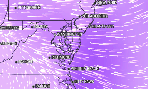
 |
AccuWeather Wind Flow map shows stiff easterly winds moving onshore in the mid-Atlantic on the morning of Oct. 29, 2021. |
Gusty winds from the east and northeast will continue to push water toward the Atlantic coast and into the bays and tidal rivers. This effect will lead to tides of 1-4 feet above normal and coastal flooding. The coastal flooding will be the worst around the time of high tide. In low-lying communities that are most prone to coastal flooding can be hit with the heaviest rain at the same time, which can elevate the risk of inundation.
The Inner Harbor of Baltimore, the tidal basin around Washington, D.C., and portions of Philadelphia; Annapolis, Maryland; Wildwood, New Jersey; New York City and Boston can be hit hard with the nearly simultaneous effects of heavy rain and above normal tides.
 |
This graph shows lunar-based tides (blue/normal) versus storm-generated tides (red/actual) at Battery Park, New York City. Tide levels were already running nearly 2 feet above normal as of Saturday afternoon, Oct. 30, 2021, and may trend even higher later today. (National Oceanic and Atmospheric Administration [NOAA] Tides and Currents) |
 |
In addition to the various concerns for flooding, winds can be strong enough to cause some top-heavy trees to tip over or waterlogged limbs to break off. With the progression of leaf drop behind average pace and the saturated soil, there is an elevated risk of power outages from the central Appalachians and mid-Atlantic to New England.
Chilly conditions will accompany the rain. The combination of the rain and a breeze will produce AccuWeather RealFeel® Temperatures that can dip 5-10 degrees Fahrenheit lower than the actual temperature. Those venturing out will not only need rain gear such as waterproof shoes, a raincoat or storm-proven umbrella, but also a warm layer of clothes as well to combat RealFeel temperatures in the 50s and 40s in many areas and even the 30s over some of the higher elevations.
CLICK HERE FOR THE FREE ACCUWEATHER APP
There is some good news for those partaking in outdoor Halloween activities on Sunday. While there will be chilly air and showers from the Ohio Valley to the central Appalachians, mid-Atlantic, eastern Great Lakes and southern New England, the worst of the rain and flooding problems should be over by then. And by the holiday itself, even northern New England should join in the drying trend.
 |
The large circulation of the storm will contribute to a significant change in the weather pattern through the upcoming week.
Much colder air is forecast to drop southward across the North Central states and reach part of the Northeast. This pattern change could set the stage for more storms to roll along, and the air could even be cold enough to allow for a couple of episodes of snow for the Appalachians and Midwest.
For the latest weather news check back on AccuWeather.com. Watch AccuWeather Network on DIRECTV, DIRECTVstream, Frontier, Spectrum, fuboTV, Philo, and Verizon Fios. AccuWeatherNOW is streaming on Roku and XUMO.
