Early-season wildflowers, waterfalls and views highlight Coyote Wall Loop Trail
If there’s one thing Northwest hikers love, it’s variety. From wildflowers and waterfalls to rocky faces, pine forests and grassy meadows, Oregon and its neighbor to the north have it all. Where things get magical is when you can experience these things in one day hikes.
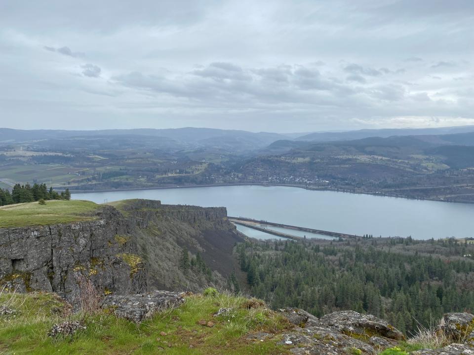
Coyote Wall Loop Trail, outside of White Salmon, Washington, is one of these special places. Just an hour's drive east of Portland, the 6.8-mile, moderately challenging trail offers hiking, mountain biking and seasonal horseback rides to the top of a rocky cliff with views over the Columbia River Gorge from Hood River to The Dalles.
The trailhead, located along Lewis and Clark Highway 14, offers trails at a range of difficulties and lengths.
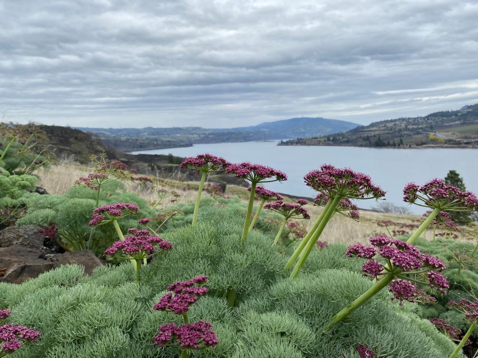
The lower stretch of the area features robust early-season wildflowers. A trip up the gradual incline on the east side of the loop takes you through a grassy meadow with bright yellow, white and purple wildflowers dotting the landscape. The occasional mushroom, too.
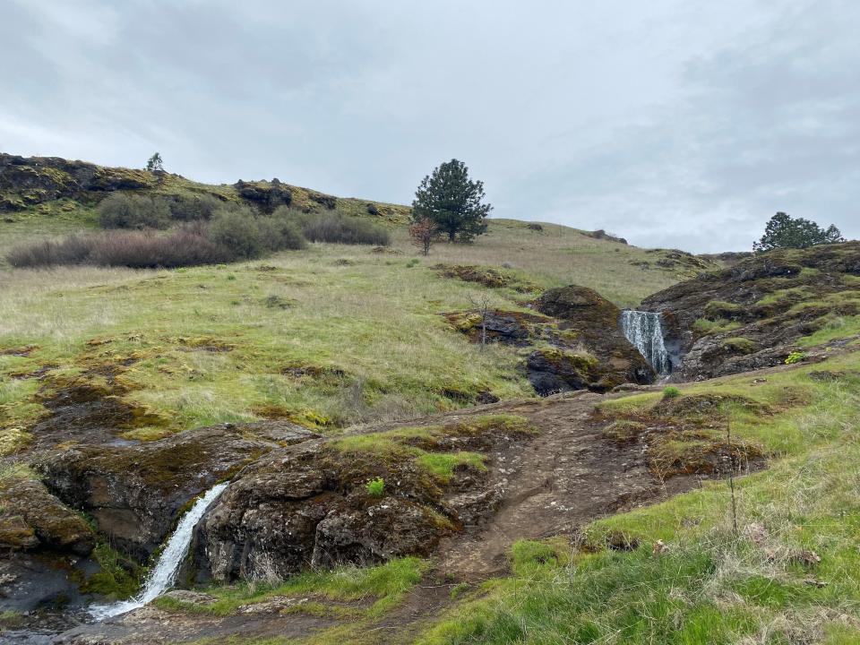
The east side of the loop follows Maui Creek, which boasts a series of small waterfalls.
Peak wildflower season is March through Mid-May, although that can change depending on conditions.
The hike
You can begin by parking in the designated area along Courtney Road and walking up Old Highway 8, starting at the east end of the lot. The only way to reach the trailhead is by walking up the road, which is closed to motorized vehicles. The AllTrails map will direct you this way, and can be used as a tracking mechanism to know you're headed the right way.
The hike can be confusing, as it mixes sections of hiking on roads and trail in one larger recreation area. The maps aren't perfect, but you can find them at bit.ly/4087qmI and bit.ly/3muMgSh.
Once on the old road, you'll notice large basalt boulders scattered on the pavement from a rockslide of years passed. Don't worry, you're in the right place.
A little over a half-mile later, walking along the old road, you'll notice a trail on your left side with a sign for the Coyote Wall trail. Take it, and a few minutes later, you'll reach a fork. Hanging to the right, you'll take the Little Maui Trail, which makes up the east side of the loop.
About 1 mile of switchbacks later, the trail flattens out and comes to a fork. Hanging right connects you with the top of the Coyote Wall ridge. You’ll follow steep switchbacks up the ridgeline for the remaining 1.5 miles of the ascent. This section is challenging and guarantees a calve-burning cardio workout, with stunning views over the thickly forested canyon below to make it all worthwhile.
In this section of the hike, wildflowers become quite scarce, replaced by medium-length, tan and light green grass. The trail can be quite muddy and slick in this stretch on wetter days, so wear adequate boots or shoes with traction.
Vegetation changes in the final stretch of the trail, as you encounter a thick mix of pine and deciduous trees at the highest point of the wall’s rim.
The top of the trail connects with Atwood Road and loops back along the wall’s rim for panoramic views over the Gorge and into Mosier and The Dalles on the Oregon side of the river.
On the way down, you'll begin the same way you came, but at the fork you'll take a right, toward Little Moab Trail. Taking the west side of the loop down you’ll see unique rock structures and high faces. Wildflowers and mushrooms are plentiful for the bottom half of this leg.
If you go soon, you'll see large patches of long-stemmed yellow flowers colloquially called Pungent Desert Parsley. The name doesn't lie, and the earthy, herbal smell lingers throughout the lower half of the loop. There will also be occasional offerings of purple and pink Columbia Desert Parsley.
The Coyote Wall hiking area offers a special glimpse into the variety of the Pacific Northwest. From waterfalls and sprawling meadows to basalt cliffs and ponderosa pines, this place has it all.
Coyote Wall Loop
In a nutshell: A large basalt landmark accessible by day hike, mountain bike or horseback.
Trip: 6.8 mile loop.
Location: Five miles east of White Salmon, Washington, on Highway 14.
Trailhead: Coyote Wall Trailhead, Old Highway 8.
Weather: The Coyote Wall Loop Trail is predominantly uncovered, so wear rain gear and dress warm if you’re expecting weather.
When to go: This trail is highly trafficked on weekends, so starting early or going during the week on less crowded days are always good ideas if you’re looking to avoid the crowds.
Fee: No fee.
Directions: Take Interstate 84 East from Portland, cross the Columbia River at Hood River Bridge, and take a right on Highway 14. In 6 miles, take a left on Courtney Road. The trailhead parking lot will be on your right.
Charles Gearing is an outdoors journalism intern for the Statesman Journal. He can be reached at cgearing@gannett.com.
This article originally appeared on Salem Statesman Journal: Columbia River Gorge's Coyote Wall Loop Trail offers hiking

