An east-west streetcar? Kansas City transit officials unveil proposal for 16 new stops
- Oops!Something went wrong.Please try again later.
The Kansas City Area Transportation Authority and the Kansas City Streetcar began looking into an east-west streetcar route in April 2022.
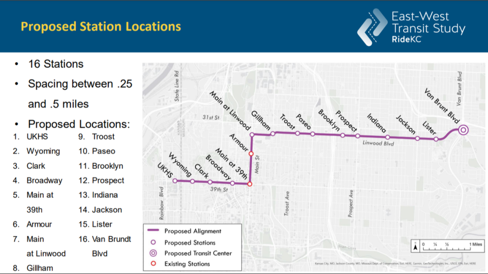
On Thursday, they unveiled plans for 16 stops along 39th Street, Linwood Boulevard and Main Street. The route would connect Van Brunt Boulevard all the way to the University of Kansas Health System.
The proposed stops are around a quarter to a half-mile apart and would connect with nearby public transit, similar to the Main Street streetcar route and bus lines.
The proposed route was identified in the first phase of the East-West Transit Study, which involved public meetings, one-on-one meetings, micro meetings and digital engagements, project manager AJ Farris said during a meeting held over video conference.
The results he received from the phase one survey suggested the streetcar is the preferred option, with 73% of surveyors wanting the streetcar instead of a bus line.
In the same survey, 60% of people preferred the route to go through Linwood Boulevard instead of 31st Street. Alex Miller, a communications strategist at Parson + Associates, said “a little over 2,000 people” took the survey, and around 1,500 of those people took the survey online. He did not reveal the demographics of the participants in the survey.
The proposed route would cost between $560 million and $650 million, according to study documents.
KCATA and KC Streetcar are looking for public feedback on the proposed route. They have a survey open for residents to take online, which will be open until 11:59 p.m. on Dec. 1
Farris said the next phase in planning for the proposed route includes environmental review, preliminary engineering, advanced planning and continuing their public engagement efforts.
After that, he said, they will begin coordination with the Federal Transit Administration, which he said would allow them more opportunities to receive funding for the study.
Where are the proposed stops for the streetcar?
KCATA provided 16 possible stops for the streetcar’s east-west route:
State Line Road and W. 39th Street at the University of Kansas Health System
Wyoming and W. 39th Streets
Clark Avenue and W. 39th Street
Broadway Boulevard and W. 39th Street
W. 39th and Main Streets
Armour Boulevard and Main Street
Main Street and Linwood Boulevard
Gillham Road and Linwood Boulevard
Troost Avenue and Linwood Boulevard
The Paseo and Linwood Boulevard
Brooklyn Avenue and Linwood Boulevard
Prospect Avenue and Linwood Boulevard
Indiana Avenue and Linwood Boulevard
Jackson Avenue and Linwood Boulevard
Lister Avenue and Linwood Boulevard
Van Brunt and Linwood Boulevards
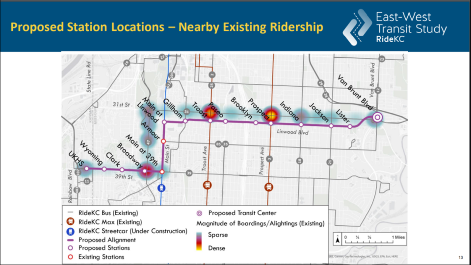
KCATA and KC Streetcar are working with City of Kansas City, Missouri, the Unified Government of Wyandotte County and Kansas City, Kansas, and the University of Kansas Health System to evaluate public transit options between Van Brunt Boulevard and KU Health System.
What would the streets look like if the east-west route is implemented?
If the east-west streetcar route is approved, six route options will change the roads along the proposed route.
Each option includes shared-use lanes of the same kind used on the Main Street route.
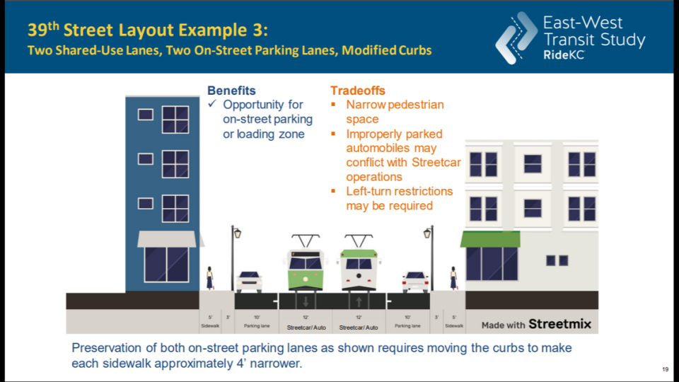
39th Street options
The first option for 39th Street features a dedicated parking lane next to the shared-use lane.
The second removes on-street parking in favor of a turning lane between the shared-use lanes.
Option three adds dedicated parking lanes to both sides of the shared-use lanes.
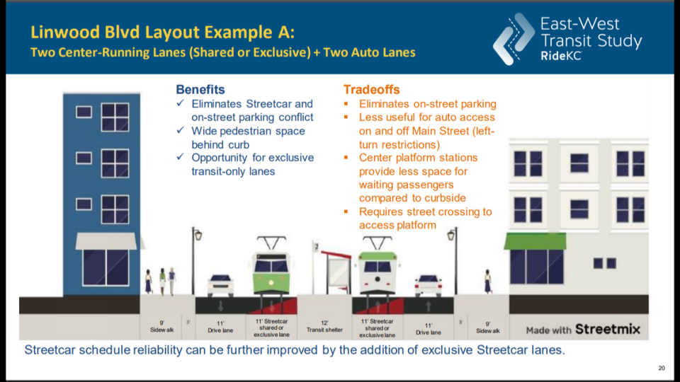
Linwood Boulevard options
Dedicated driving and streetcar lanes are shown in the first option for Linwood Boulevard, along with a transit shelter in between the streetcar lanes.
For option two, driving lanes are in the middle of the streetcar lanes and protected biking lanes are added to each side of the street.
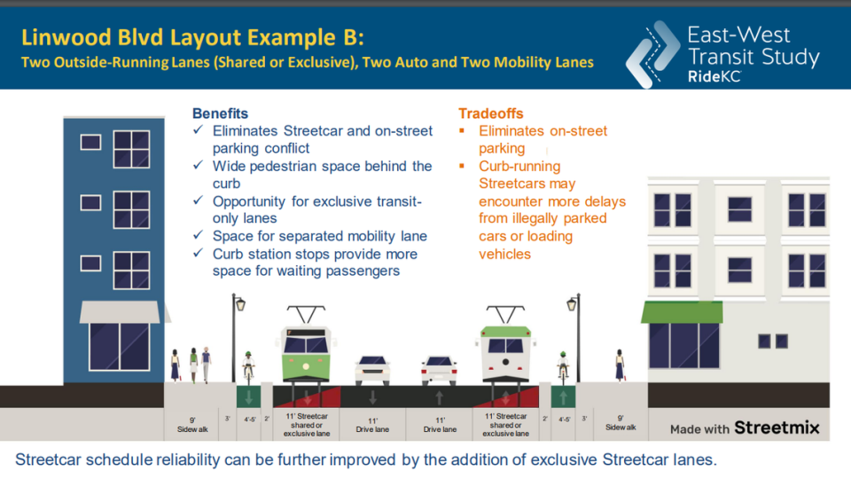
The third option features protected bike lanes on each side, a parking lane, shared-use lanes and a transit shelter.
The biggest reason for the route ending up on Linwood Boulevard instead of 31st Street was the availability of a right-of-way, Allison Buchwach, the planner IV for Kansas City-based infrastructure design firm HNTB, said during the meeting.
“Linwood is twice as large in terms of right-of-way to make space for a streetcar, so that allows us to consider things like dedicated lanes, whereas 31st Street that’s a non-starter,” she said.
“There’s not enough room on that street to have dedicated lanes and the advantage of considering that option is to have a more reliable and potentially faster travel speeds through the corridor.”

