Eastward shift in Friday storm could mean less-than-expected snow accumulations here
PETERSBURG — Forecasters now think that an easterly swing in the path of Friday's anticipated snowstorm could drop the expected accumulation around here by a couple of inches.
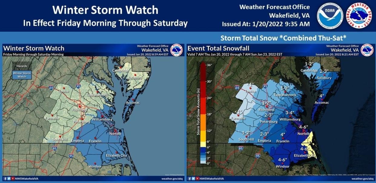
Meanwhile, Thursday's precursor to that storm pretty much met meeting initial expectations of sloppy conditions, including patchy ice on the roads and snow sticking mostly to grassy areas. About an inch of snow will be tallied by the time Friday rolls around.
"It looks like it will move a little further to the east," Wayne Albright, a National Weather Service meteorologist in Wakefield, said of Friday's storm. Initial predictions of as much as six inches of snow across the Tri-City area could drop to about 2-3 inches if the storm stays on that eastern path, Albright noted.
The heavier snow will fall east of Wakefield into the Tidewater area, but NWS noted that even those totals have been downsized. Norfolk and Virginia Beach were expected to get 6-8 inches; now, the weather service says that likely will be 4-6 inches.
The entire area is under a Winter Storm Watch for Friday.
Despite the downgraded accumulations, many were not planning to take any chances. Area schools closed up to three hours early Thursday, and the possibility exists that those doors could remain shuttered Friday depending upon overnight conditions.
Friday's storm also has produced a change in Petersburg city government operations. All city offices will be closed, but essential personnel are expected to report while non-essential personnel will work from home.
Petersburg Area Transit will operate on a two-hour delay in service Friday, the city said.
Petersburg's police, fire and public works departments will be monitoring road conditions, and the city is asking residents to limit travel unless absolutely necessary.
"Road crews are better able to cover streets with less traffic," Petersburg spokesperson Joanne Williams said. Where available, off-street parking should be used.
Gov. Glenn Youngkin issued a state of emergency ahead of the storm.
The official NWS forecast is for light snow to begin falling Friday afternoon, with the majority accumulation to come Friday night. The precipitation will clear out late Friday, and Saturday is expected to be sunny, but the temperatures will stay in the 20s Friday dipping down to the teens Friday night, then in the mid-30s on Saturday.
Click here to read the complete forecast.
The Progress-Index encourages readers to share photos and videos from the storm. Upload them to The P-I's Facebook page or email them to newsroom@progress-index.com.
This is a developing story, and updates will be provided as warranted.
More habitats: Tri-Cities Habitat for Humanity is looking to bring new development into Petersburg
Gun grant: Petersburg receives $300,000 for gun violence prevention initiatives and programing
No tie-in to work: Virginia State University no longer requires employees to be COVID vaccinated or tested
Bill Atkinson (he/him/his) is daily news coach for USA TODAY's Southeast Region-Unified Central, which includes Virginia, West Virginia and central North Carolina. He is based in Petersburg, Virginia. Reach him at batkinson@progress-index.com.
This article originally appeared on The Progress-Index: Eastward shift in Friday storm could mean lower snow totals here

