Ecola State Park trail, once a showcase of ocean views, moved inland after landslides
Hiking at Ecola State Park used to come with some of the Oregon Coast’s most magnificent ocean views.
The stretch from Ecola Point to the Tillamook Head was a quintessential oceanside hike, offering long looks at ragged coastline and the historic “Terrible Tilly” lighthouse.
Due to landslides that have plagued the popular Oregon state park over recent years, the trail no longer provides the seaside vistas it used to.
“The most recent change of that trail was a very intentional shift and it was a result of some slide activity that took out a couple of sizeable portions of the trail footprint," Ben Cox, who's managed Ecola State Park since 2016, said. "It was much closer to the shoreline, and there were some more opportunities to see vistas, but we felt that continuing to put people through that track wasn't safe."
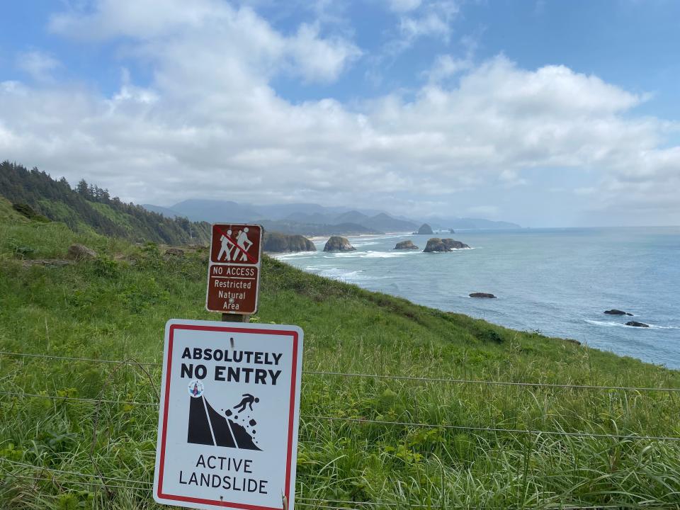
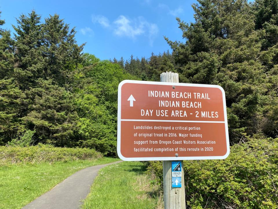
The altered route to Indian Beach, finalized in fall 2020, traverses more forest than coastline.
This 6.8-mile lollipop loop combines two trails that mix lichen-covered old-growth trees, sword ferns and moss before shooting out onto brief, yet striking ocean lookouts – relics of the trail that used to traverse the sea cliffs.
Finding the trail
Driving north on Ecola State Park Road from Cannon Beach, take the first left toward Ecola Point. Once there, park, pay the $5 day-use fee and pick up the Indian Beach trail from the northwest corner of the parking area.
This hike is open year-round. Most of the trail is covered by thick fir canopy, with stands of old growth strewn throughout, making this hike a delight for any season. A map of the hiking area, as well as an elevation profile and mileage information, can be found on the state park website.
From sea, to old-growth forest and back
You’ll leave the clear, unforested Tillamook head vantage point behind you in the parking lot, swapping it for the silence of thick, coastal forest. The trail quickly veers away from the ocean.
Crossing a creek dotted with lillies roughly a tenth of a mile in, the trail begins its gradual series of switchbacks. It’ll be enough to get the blood pumping.
The switchbacks proceed with varied frequency for the first mile of the hike. Following a steady yet mellow incline, the trail continues to run away from the ocean, offering a tour through the heavily vegetated coastal forest biome. Mushrooms, ferns and fallen logs cover the understory, with age-old trees towering above.
A mile later, the route reaches a plateau atop a ridgeline. The state park road that parallels the trail to the right can be seen but seldom heard through the tightly packed trees. While no ocean views will be found to the left, hikers can enjoy the sights and sounds of the rainforest.
After a third of a mile in a straight line along the ridgeline, the trail bends west back towards the ocean and begins a gentle decline of varying degrees. After a handful of switchbacks, hurdling a pair of fallen trees and about a half-mile hiking toward the sea, the trail hosts its first, and perhaps most striking, ocean views since the beginning.
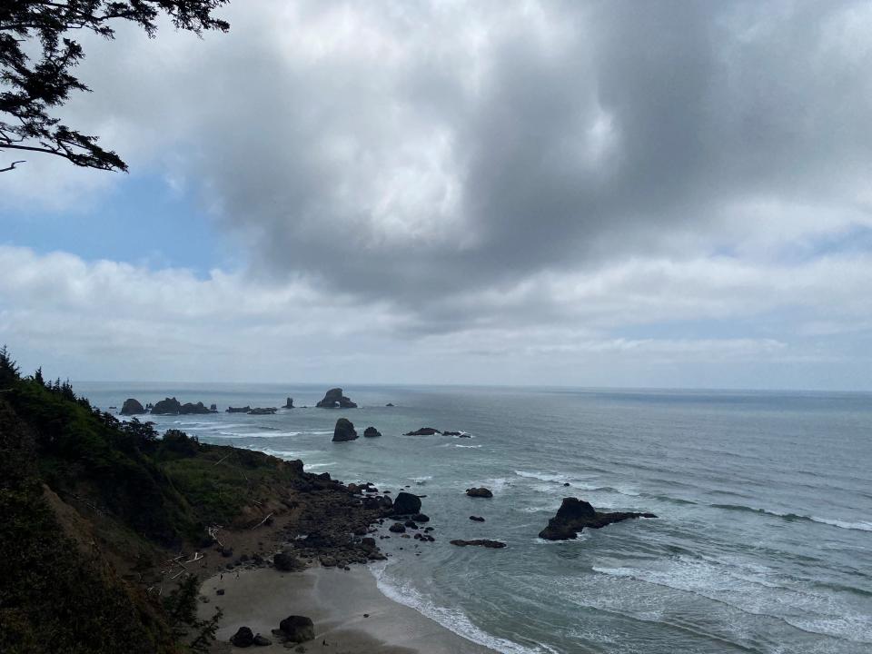
In this section, hikers find themselves on a stroll through the headlands above Indian Beach, made famous by stark rock faces and cliffs, predictable and surfable waves, and views of Tillamook Light, a revered decommissioned lighthouse from the 1800s.
The lighthouse earned the nickname Terrible Tilly in the years before sonar when the foggy, rocky and rough-waved Oregon Coast was much more dangerous than today.
The beach can be accessed at two points, one from the trail and another from a separate trail that goes directly from the Indian Beach Day Use Area and parking lot. This area, equipped with restrooms, picnic tables and soft sand, makes for the ideal sunny day picnic spot. Hikers should be sure to set aside some time to take in the scenery.
The Indian Beach Day Use parking lot marks the end of the Indian Beach trail and the start of the 2.8-mile Clatsop Loop trail. Hikers looking for an abbreviated experience could turn back to Ecola Point here, but I recommend following through to the loop.
Ancient trees and coastal vistas
The Clatsop Loop begins next to the restrooms at the north end of the Indian Beach Day Use Area.
The trail comes to a fork after a tenth of a mile. Left brings you up the west side of the loop, and the right goes to the east side, which follows a gravel, lightly-used forest road to a striking ocean viewpoint with head-on views of the Tillamook lighthouse and the basalt cliffs below.
By choosing to start on the east side of the loop, you can save the best, most scenic stretch for last. That was what I chose to do and soon found myself on a calf-burning climb that goes on for about a mile. During this stretch, you may be the only one on the trail, even on the busiest of days. The scenery is more forest — but that’s not a bad thing.
Look for elk walking the vegetated floor and rare bird life in the overstory.
After one long, steep mile, the trail will cut left toward the ocean, passing the Hiker’s Camp where through-hikers of the Oregon Coast Trail can spend the night. The camp has three large huts equipped with sleeping bunks.
Past the hiker’s camp, the trail aims directly at the coastline on a brief downward slope before meeting the top of its loop at the Tillamook head overlook. It’s a small gap in the vegetation with one short bench, perfect for a brief moment of solitude before making your way back.
The west side of the Clatsop Loop, which I chose as my route back towards Indian Beach and Ecola Point, is more notable, and definitely more gradual than the east. Its thin, lesser trafficked switchbacks traverse the jagged coastal cliffs and offer stellar views of Oregon’s big blue neighbor while giving hikers an up-close look at the forested landscape.
Throughout this section, you’ll be in striking distance of the ocean, feel the breeze, and much to your delight, walk a gentle, easygoing downhill pace. After 1.4 miles back down to the Indian Beach Day Use Area, hike an additional two miles back to the Ecola Point Day Use Area, where it all began.
Whether you're looking to get in a nice workout, hike to the beach, or kill a few hours at one of Oregon's most renown state parks, this route checks all the boxes for the ideal northern coast day hike.
Ecola Point to the Clatsop Loop
In a nutshell: A 6.8-mile lollipop-shaped loop that offers beach access, cliffy viewpoints and old-growth forest.
Trip: 6.8 miles.
Location: Three miles north of downtown Cannon Beach at the Ecola Point Day Use Area on Ecola State Park Road. Coordinates: 45.919494, -123.971649
Trailhead: At the northwest corner of the parking lot at Ecola Point Day Use Area.
Weather: This hike is an excellent choice year-round.
When to go: This trail is heavily trafficked. If you want the place to yourself, start early or go on a weekday.
Fee: $5 fee or recreation pass is required.
Map: Ecola State Park
Directions: Take Alternative Route Highway 101 North out of downtown Cannon Beach. Turn left on Ecola State Park Road and continue for 1.5 miles. Turn left, following signs for Ecola Point. Park in the lot and find the trailhead by foot from there.
Charles Gearing is an outdoors journalism intern for the Statesman Journal. He can be reached at cgearing@gannett.com.
This article originally appeared on Salem Statesman Journal: Ecola State Park trail, once a showcase of ocean views, moved inland

