El Niño is increasingly likely this year. Here’s what it could mean for Kentucky weather
Weather forecasters say El Niño is on its way, and according to the latest outlook from the Climate Prediction Center, the Bluegrass State is leaning toward above average temperatures and precipitation between May and July.
“El Niño is likely (62% chance) to develop within the next three months and very likely (80%) by fall,” Ron Steve, a meteorologist with the National Weather Service in Louisville, told the Herald-Leader in email Tuesday.
While El Niño has a greater influence over winter weather in Kentucky, it does affect our summers in some important ways, Steve said.
Here’s what to know about El Niño, its counterpart La Niña and how they shape weather in Kentucky.
What are El Niño and La Niña? What’s the difference between them?
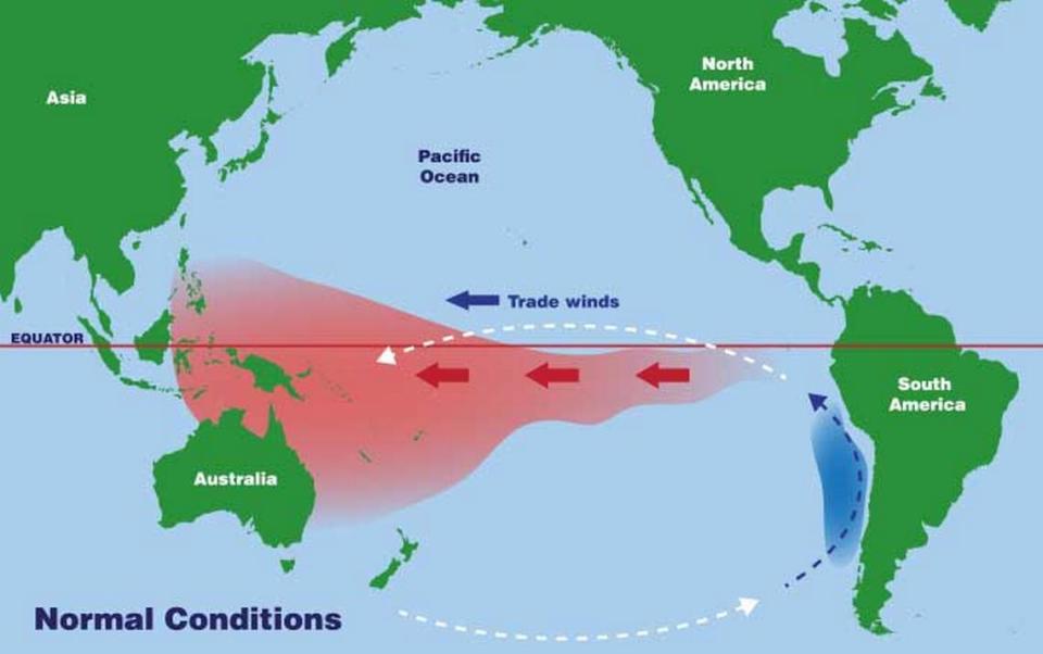
Put simply, El Niño and La Niña, are contrasting climate patterns that originate from the Pacific Ocean. They influence weather worldwide, but in different ways.
The National Oceanic and Atmospheric Administration defines El Niño (in Spanish “little boy”) as a weakening of the trade winds that normally blow from east to west. As a result, warm water is pushed eastward, toward the west coast of the U.S. Those warm waters in turn warp the Pacific jet stream, bending it south of its neutral position, according to the NOAA.
The end result is Canada and the northern U.S. warm up and get less precipitation, while the Gulf Coast and southeast U.S. see greater precipitation and become more flood-prone.
Compare that to La Niña, “little girl” in Spanish and the opposite of El Niño. Under La Niña, the trade winds get a boost, allowing them to draw more warm water toward Asia.
Colder water in the Pacific Ocean bends the jet stream north. It produces the opposite effect of El Niño. The southern U.S. tends toward drought, while heavy rains drench the Pacific Northwest and Canada, according to the NOAA.
La Niña often means warmer winter temperatures in the south and cooler than normal in the north, according to the NOAA. The conditions are favorable for more frequent hurricanes, as well.
These climatic patterns happen every two to seven years, but not on a regular schedule, according to the NOAA. El Niño tends to happen more frequently than La Niña.
What does the developing El Niño mean for weather in Kentucky?
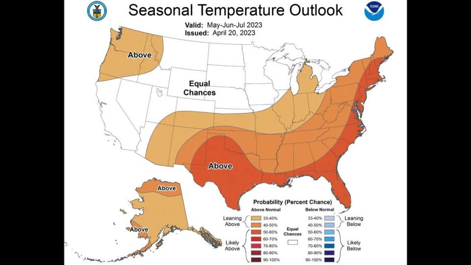
Given that El Niño generally brings more precipitation to the Southeast U.S, the latest outlook from the NOAA indicates Kentucky has a greater chance of seeing more rainfall this summer.
Roughly two-thirds of the state has a 40% to 50% chance of greater than average precipitation for this time of year.
According to Steve, the NWS forecaster, one of the biggest factors is the southwest monsoon that drives the rainy season over the Arizona and New Mexico desert during the early to midsummer.
This year, Steve expects the southern monsoon to grow more slowly.
Forecasters often say weather behaves like a seesaw.
“Frequently we say: ‘cold in the west equals warm in the east’ or vice versa,” Steve said. “In this case, it’s dry in the west, wet in the east (including the Ohio Valley).”
Kentucky also has an increased chance of experiencing above normal temperatures this summer, according to the NOAA outlook, which is current as of April 20.
“Above normal temperatures are favored here in Kentucky because we had a very mild winter and a somewhat warm and dry spring,” Steve said. “When the ground is relatively warm and dry, it can heat up a bit more efficiently,” creating a reinforcing warming effect.
Conversely, when the weather is warmer and the ground is wetter, water more rapidly evaporates from the soil and rises into the air, where it condenses and falls again as rain. If the weather stays warm and wet, this cycle plays out repeatedly.
But this year, given the cooler temperatures Kentucky saw in April, the lean toward warmer temperatures for the upcoming three months in the Ohio Valley is not as strong as it was, Steve said.
Still, regardless of how warm it will be in Kentucky this summer, the coming El Niño is expected to fuel rising temperatures around the world.
“We just had the eight warmest years on record,” Petteri Taalas, the secretary-general of the World Meteorological Organization, said in a recent news release. “... Even though we had a cooling La Niña for the past three years, this acted as a temporary brake on global temperature increase.”
“The development of an El Niño will most likely lead to a new spike in global heating and increase the chance of breaking temperature records,” Taalas said.
Do you have a question about the environment or climate in Kentucky for our service journalism team? We’d like to hear from you. Fill out our Know Your Kentucky form or email ask@herald-leader.com.

