El Niño intensifies: What does it mean for the US this winter?


 |
A map showing the sea surface temperature anomalies across the Pacific Ocean. Areas of yellow, orange, red and pink are areas where the water is warmer than the historical average. The warm waters related to El Niño are west of South America. (NASA Worldview) |
The start of meteorological winter is just four weeks away, and it could be a doozy for some parts of the United States as El Niño heats up and reshapes the weather over North America.
El Niño is a phenomenon that occurs when the water near the equator of the eastern Pacific Ocean is at least 0.9 of a degree Fahrenheit (0.5 of a degree Celsius) above the historical average for an extended period of time. It officially developed in early June and has continued to flex its muscles, setting the stage for the first winter with an El Niño since the 2018-19 season.
In an update issued by NOAA on Thursday, the agency said that a "strong" El Niño is now present in the Pacific Ocean, and it continues to show signs of strengthening.
From NOAA: "There is a greater than 55% chance of at least a 'strong' El Niño persisting through January-March 2024," NOAA said in a press release. "There is a 35% chance of this event becoming 'historically strong.'"
The rise of El Niño is a significant reversal from the previous three winters when its cooler counterpart, La Niña, reigned supreme. This flip will have significant impacts on the weather across North America throughout the winter season, some of which are already starting to be felt.
 |
The sky turns red as the sun goes down over the Pacific Ocean in 2012 in Malibu, California. (Photo by Roxanne McCann/Getty Images) |
Although El Niño takes place in the Pacific Ocean, it reshapes the jet stream, and ultimately, the weather thousands of miles away. The weather patterns are much different than when La Niña is present, which is why AccuWeather long-range meteorologists say that this winter could be much different than recent years.
From the experts: "El Niño will be a 'dominating factor' for our winter forecast," AccuWeather Long-Range Forecaster Paul Pastelok said.
 |
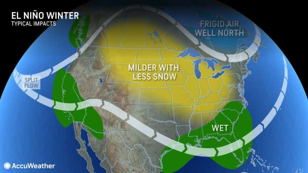
An El Niño pattern often ushers in an active storm track and resultant wetter conditions than the historical average across southern parts of the U.S. |
AccuWeather meteorologists are predicting a wetter winter across the South, while areas across the Great Lakes, Midwest and the northern Plains experience less precipitation and milder conditions. Along the West Coast, El Niño tends to direct moisture-rich storms into California rather than the Pacific Northwest.
Along the East Coast, El Niño can also set the stage for big snowstorms, which is why AccuWeather is forecasting more snow this year than last winter in New York City, Philadelphia and Boston.
Between the lines: The ongoing El Niño is already stronger than the most recent El Niño during the winter of 2018-19, meaning that it will have more pronounced impacts. "Not every El Niño is the same," Pastelok added.
To read the complete region-by-region breakdown of the U.S. winter forecast, click here.
Want next-level safety, ad-free? Unlock advanced, hyperlocal severe weather alerts when you subscribe to Premium+ on the AccuWeather app. AccuWeather Alerts™ are prompted by our expert meteorologists who monitor and analyze dangerous weather risks 24/7 to keep you and your family safer.
