El Niño is likely in 2023. Here’s what that could mean for North Carolina weather
Just as three consecutive La Niñas finally stop affecting global weather patterns, conditions in the swirling waters of the Pacific Ocean strongly suggest an El Niño could arrive in the coming months, weather experts say.
The World Meteorological Organization, an arm of the United Nations, estimates the likelihood of an El Niño developing in May or June at 60%, with the likelihood increasing to 80% by October.
NOAA, the National Oceanic and Atmospheric Administration, has predicted a 61% chance that an El Niño will be in place by August through October.
What is El Niño?
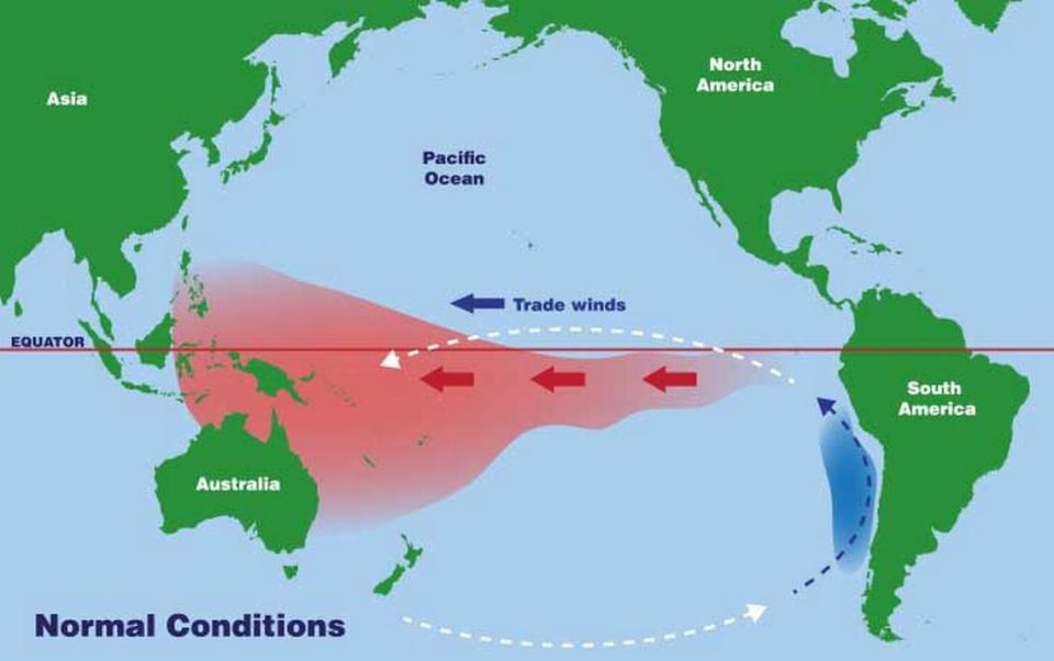
El Niños, as well as their opposites, La Niñas, are naturally occurring weather phenomena that usually appear every two to seven years as a function of the way the Pacific Ocean interacts with the air above it.
El Niños happen when the Trade Winds — winds that blow along the equator, east to west over the Pacific — weaken, causing the warmer water to move east toward South America, accumulating there before moving north to California and south toward Chile, NOAA says.
In El Niño years, NOAA says, rain clouds form over the warm ocean water and move inland, dropping more rain than usual in South and Central America and in the U.S.
During an El Niño winter, the Southeastern U.S. is usually cooler, sometimes enough to bring snow, and often wetter, sometimes enough to cause flooding.
Meanwhile, other parts of the world may see droughts during El Niño years.
What’s the difference between an El Nino and La Nina?
A La Nina happens when the Trade Winds are abnormally strong, sending warm water from off of South America, in the eastern Pacific, toward Asia and Australia, in the western Pacific.
As the warm water moves west, it takes tropical rainfall with it, disrupting the normal circulation of the atmosphere and affecting jet streams.
During a La Niña, it’s typically drier and warmer in the Southeastern U.S. beginning in the fall and going through the winter. La Niñas also can affect the Atlantic hurricane season, which runs from June through November, helping to increase the number and severity of storms.
What would El Niño mean for North Carolina?
In North America, the most pronounced effects of an El Niño are felt in the winter, and they vary by region. In North Carolina and across the Southeast, an El Niño could mean colder temperatures in December, January and February, and more precipitation.
If the El Niño develops this summer, it could reduce the number of tropical storms and hurricanes that make it to the North Carolina coast, or weaken the storms that do make landfall.
What’s most unusual about the WMO’s forecast of a 2023-24 El Niño is the timing of it, said Corey Davis, assistant state climatologist at the N.C. State Climate Office.
“The one thing that’s a little surprising is just how quickly the La Nina disappeared, and how quickly this El Niño is developing,” he said. “As soon as we got into February and March, and that cool water in the Pacific started to disappear, and now warmer water is taking its place.
“So there is unusually high confidence in an El Niño for this point in the year. Usually, we don’t know until the summer.”

Will El Niño mean more summer storms and hurricanes in NC?
If the El Niño forms in time to affect the Atlantic hurricane season, it can be beneficial, keeping storms that form off of Africa from reaching the U.S. coast. Wind shear created by an El Niño also can tear apart storms that form closer to shore.
Forecasts for the Atlantic hurricane season for 2023 vary, with different sources calling for 11 to 19 named storms, up to nine of which could become hurricanes, as many as five of which could be major hurricanes with Category 3 winds or higher.
The effects of an El Niño depend on how strong it is, as well as other weather factors. El Niños are classified from “weak’ to “very strong” by how much they cause the Pacific Ocean’s surface water temperature to stray from the norm. The last strong El Niño was in the winter of 2015-16.
El Niños and La Niñas both can affect mean temperatures, raising and lowering concerns about long-term global warming depending on how strong they are.
Sometimes, El Niños mean more snow in North Carolina, but not always, Davis says. The winter of 2015-16, with a statewide average temperature of 44.61 from December through February, was the 16th warmest since 1895. It was also the 4th wettest during that time period, but most of the state saw below-normal snowfall.
Will an El Niño bring back snow to NC this year?
Davis says it’s too early to tell about winter snow forecasts.

