Emergency declared for 33 Florida counties as storm forecast to reach hurricane strength
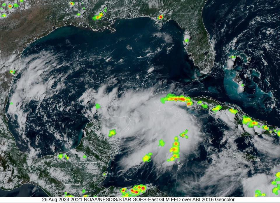
An ambitious twist of thunderstorms near the Yucatan Channel reached tropical depression status Saturday and is on a path that whips it toward the west coast of Florida as a Category 1 hurricane.
The forecast for Tropical Depression 10, which has the system reaching Florida late Tuesday into Wednesday with 75 mph winds, triggered a state-of-emergency declaration from Gov. Ron DeSantis for 33 counties from Bay County in Florida’s Panhandle to Lee County on the southwest coast.
Palm Beach County and the Treasure Coast were not included in the declaration but are expected to get up to 2 inches of rain through Thursday.
As of 5 p.m. Saturday, the depression had sustained winds of 30 mph with higher gusts. It was located about 65 miles northeast of Cozumel, Mexico. A tropical storm with sustained wind speeds of 39 mph is expected to form Sunday. It will be named Idalia.
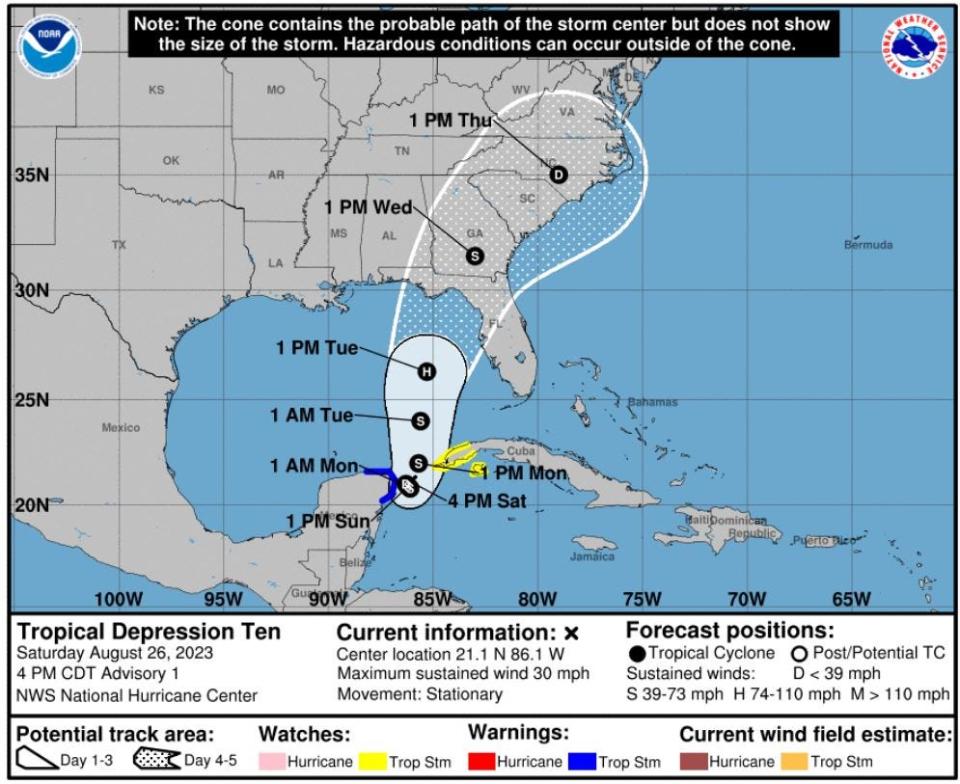
The forecast track cone reaches from just east of Fort Walton Beach to Bradenton with the center going into Taylor County in the lightly inhabited Big Bend region.
Meteorologists at the National Weather Service in Tampa are forecasting 6 inches or more of rain for areas from Chiefland to Punta Gorda through Thursday morning. Fort Myers and Naples could see up to 4 inches.
With areas along the west coast in moderate to extreme drought, meteorologist Austen Flannery at the NWS Tampa office said the rains could be beneficial.
"The main concern right now for the west coast is heavy rainfall," Flannery said. "The good news is we could handle a good amount of rainfall without a problem."
2023 hurricane season: Fear rain as much as storm surge as climate change increases threat
A full moon Wednesday may also exacerbate storm surge with higher-than-normal tides. The Tampa NWS office forecast storm surge heights to reach three to five feet above ground level.
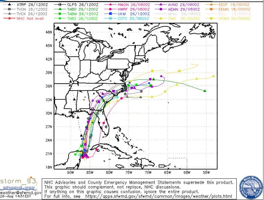
Meteorologists cautioned Saturday against focusing on a single path or potential storm strength as the cyclone is still in its infancy. If it reaches hurricane strength, it will be the third of the season following Don and Franklin.
As of Saturday, TD 10 was dawdling near the tip of the Yucatan Peninsula where it will meander until a trough of low pressure digs through the U.S. and drags it toward Florida.
Hurricane experts said Saturday they expect it to form into a tropical storm Sunday and strengthen to a hurricane Tuesday.
Bob Smerbeck, a senior meteorologist with AccuWeather, said any system that forms will feed from deeply warm water in the Gulf of Mexico, and is expected to pass over a finger of the even warmer loop current.
“It’s not going to sit on that skinny loop current line but it will definitely help it some,” Smerbeck said. “We do think it will become a tropical storm and we think as it gets closer to the northeast Gulf of Mexico, it could become a hurricane.”
Smerbeck said Saturday that AccuWeather’s confidence level was low on it becoming a hurricane and high on it reaching tropical storm strength.
The southern Gulf of Mexico waters near Invest 93L are as warm as 88 degrees and up to 165 feet deep, meaning its churn won’t bring up cooler water from below to temper its growth.
More: Think you survived a Cat 1 hurricane with Nicole? Here's how Palm Beach County got off easy
Michael Lowry, a hurricane and storm surge expert with Miami's ABC affiliate Channel 10 in Miami, wrote in his forecast that the depression is “percolating in a remarkably pristine environment.”
Lowry said the system’s track through the Gulf will also determine its intensity. A more northward-moving storm could be stronger than a southward track, which would give it less time over the warm waters.
“This is not ideal to have another storm system moving into the eastern Gulf of Mexico and potentially impacting areas still recovering from Hurricane Ian,” Tampa meteorologist Flannery said.
Hurricane Ian made landfall Sept. 28, 2022, as a high-end Category 4 hurricane near Cayo Costa in Lee County. It pushed as much as 15 feet of storm surge into Fort Myers Beach. Ian, which briefly reached Category 5 strength before weakening slightly ahead of landfall, was responsible for at least 156 fatalities, 66 of which were considered deaths directly caused by the storm, according to a National Hurricane Center report.
Most forecasts that predict a hurricane are topping it out at a weak Category 1.
But Jeff Masters, co-founder of Weather Underground and a writer for Yale Climate Connections, said storms can ramp up astonishingly fast in the Gulf of Mexico.
“There have been far too many cases in the past of western Caribbean disturbances entering the Gulf which ended up far exceeding model expectations,” Masters wrote in his Eye on the Storm column. “While the most probable outcome is that 93L will be a strong tropical storm at landfall, we should not be surprised if it makes landfall as a rapidly intensifying hurricane.”
Kimberly Miller is a veteran journalist for The Palm Beach Post, part of the USA Today Network of Florida. She covers real estate and how growth affects South Florida's environment. Subscribe to The Dirt for a weekly real estate roundup. If you have news tips, please send them to kmiller@pbpost.com. Help support our local journalism, subscribe today.
This article originally appeared on Aberdeen News: National Hurricane Center is expecting a Category 1 hurricane to develop

