Emergency declared in San Diego as wettest January day on record brings widespread flooding
- Oops!Something went wrong.Please try again later.
SAN DIEGO — Winter storms for relatively dry San Diego are hit-or-miss, but mostly miss, so the wallop of a Pacific front Monday stunned California's second-largest city even as it was expecting rain.
It was the third of three Pacific storms to strike the West Coast since Friday, with the first bypassing the region and the second producing only about one-third of an inch of relatively warm rain. A city that walked it off was then punished by the third storm, which had been forecast to be stronger.
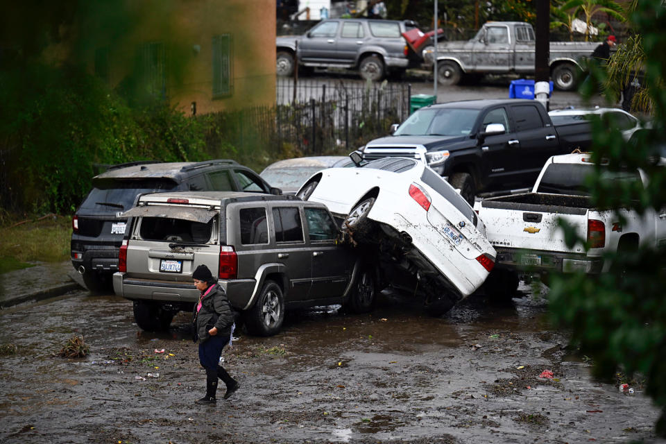
It was the wettest January day on record in San Diego, the National Weather Service said. A high school in the city was being used as a temporary shelter after about 100 homes were in some way affected by the flooding, according to Mayor Todd Gloria, who declared a state of emergency "due to extreme rainfall and flash flooding."
Video posted to social media showed cars being swept away by fast-moving waters, on roads turned into rivers.
Tijuana and other parts of northern Baja California were hit hard. At least eight migrants were rescued by U.S. Customs and Border Protection agents and San Diego Fire Department rescuers when they were endangered by the floodwaters of the Tijuana River Valley on the U.S. side, authorities said.
Residents in the Southcrest neighborhood just southeast of downtown had to be rescued by firefighters as standing water quickly surrounded their apartment complex, according to authorities and coverage from NBC San Diego. No injuries were reported.
Navy Base San Diego, south of downtown, reported flooding in the late morning as a thick cell of precipitation moved over the area and put multiple streets and Interstate 15, which leads to Las Vegas, under enough water that they were effectively shuttered.
Navy officials said personnel on base should shelter in place as they tried to move incoming and outgoing traffic to areas of the base that weren't temporarily united with adjacent San Diego Bay.
Mayor Gloria urged residents and visitors to stay off roads Monday. Schools in adjacent La Mesa and Spring Valley declared classrooms would be closed Tuesday.
"This weather event was predicted, in terms of rain, but the amount of rain in the short amount of time was a bit of a surprise to, I think, everybody," he said at a news conference early Tuesday at Lincoln High School in San Diego, which is being used as a shelter.
Gloria added that he would be asking the state governor, Gavin Newsome, for federal funds.
Sean Mahoney, regional CEO for the American Red Cross Southern California Region, told the same news conference that the shelter would be able to house 375 people, providing hot meals and mental health support. Two homeless centers have been relocated.
Working alongside @SDFD agents rescued several undocumented migrants who became trapped in flood waters near San Ysidro today after they crossed the border illegally. 8 migrants were safely rescued & taken into custody. pic.twitter.com/DJ7iHcOd8g
— Chief Patrol Agent Patricia D. McGurk-Daniel (@USBPChiefSDC) January 22, 2024
The city grappled with flooding in the usual places, including Mission Valley, where multiple roads were impassable, and Ocean Beach, where beachgoers didn’t necessarily have to reach the ocean to go for a swim.
At the north end of San Diego County, State Route 78 was shuttered east of the city of Oceanside after lanes were buried in floodwaters. Eastbound lanes remained closed Monday night, according to the California Transportation Department.
The scene was similar across the region as the storm drew moisture from the Pacific and formed an atmospheric river, what the National Oceanic and Atmospheric Administration calls "rivers in the sky," which produced once-in-a-generation effects.
The storm echoed the havoc of El Niño in 1983 or 1998 — classic years for the rainy weather phenomenon that brought widespread flooding, sizable surf and even weeks of snow to Southern California.
Monday's storm spun at the coast counterclockwise and hit northern Baja California, giving San Diego a glancing but still strong blow, NWS meteorologist Brandt Maxwell said.
The long-tail jet stream, a permanent feature that usually aims storms much farther north, and the strong atmospheric river paired up with unstable air composed of warmer atmosphere colliding with colder climes, Maxwell said. Together those elements charged up the day's storm.
The only thing missing, Maxwell noted, was strong wind.
San Diego's rain amounts have been well below normal this season, which started Oct. 1. But this single storm brought the city to slightly above normal for the year, Maxwell said.
There's still essentially half the rainy season ahead, and average annual rainfall is nearly 10 inches. The storm gave San Diego enough rain to put its season-to-date precipitation at just a hair under 5 inches for the season, Maxwell said.
To continue on a normal track or even produce an above-normal year of precipitation that would justify predictions of a rainy El Niño year for California, the Southern California coast will have to have more days like this.
It’s rare to get much needle-moving precipitation past the end of March. The storm is most likely the last one like it for January.
"At least in the short term, it doesn’t look like there’s a whole lot on the horizon for Southern California," Maxwell said.
Gloria said in the news conference that he had just got back from a conference of U.S. mayors in Washington, where attendees were in agreement that extreme weather, fueled by climate change, was the new normal.
"It doesn't matter what mayor from what part of the country, what you see is people having experiences exactly like this one.
"'We're used to snow, but not this much snow,' or, 'we're used to rain but not this much rain.' These unusual weather patterns that are really beyond people's typical experience ... it's exactly what all of us are describing and why so many of us are so active on the issue of climate change."
This article was originally published on NBCNews.com

