'Endless stream' of new storms hits California again this week. What to expect
- Oops!Something went wrong.Please try again later.
The seventh atmospheric river storm since Christmas hit California on Wednesday, and more flooding is possible as two more are forecast through the Martin Luther King Jr. holiday weekend, officials said.
Speaking to reporters in hard-hit Capitola, a beach town east of Santa Cruz devastated by storm damage, Gov. Gavin Newsom on Tuesday warned about more destruction to come. By Wednesday, the number of confirmed storm-related fatalities rose to 19.
"We're not out of the woods," Newsom told reporters. "This place is soaked. ... These conditions are serious, and they’re deadly.”
Newsom previewed three more atmospheric river-fueled storms, which should continue through at least Jan. 18, meaning another week of rain, at least for Northern California. Officials said numerous rivers still could flood with the continuing rains.
Southern California will see a reprieve until the weekend, which will probably be wet through MLK Day and perhaps Tuesday too.
"The endless stream of atmospheric river events will refocus on Wednesday across Northern California," the National Weather Service said. An atmospheric river is a plume of moisture that's essentially a river in the sky — and the most powerful ones can produce extreme rainfall, floods and landslides.
What Northern California can expect
Rainfall is hitting Northern California ahead of a large cyclone swirling in the Pacific Ocean. With soils already saturated from a parade of storms, "it won't take much additional rainfall to trigger flooding," the NWS' Weather Prediction Center said. "Scattered instances of flash flooding will be possible."
After a dramatic Tuesday that brought rockfalls and landslides across California, thunderstorms and hail to the San Francisco Bay Area, and giant trees tumbling into power lines and severe flooding in Merced County, Wednesday brought another storm system to Northern California.
Flood watches and advisories were in effect for large swaths of Northern California on Wednesday.
The hard-hit Santa Cruz Mountains and the North San Francisco Bay could see rainfall of up to 3 inches through Wednesday night, with less rain likely for the East Bay, Monterey Bay and Central Coast. Wind gusts of up to 60 mph are also possible.
Chances of rain remain through Thursday. It is unclear whether the North Bay will see any relief, and the lack of a break "would be a bad scenario," the weather service said.
A second storm could hit the San Francisco Bay Area Friday into Saturday, and a thunderstorm or two is possible.
And a third storm could strike on Sunday and persist through MLK Day into Tuesday.
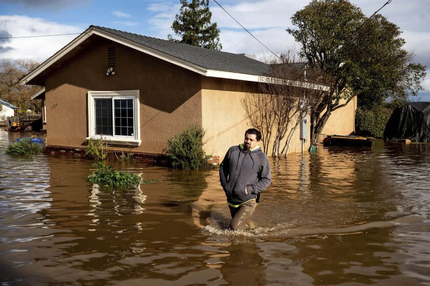
Major flooding is still underway in the Merced area, where Bear Creek, a tributary of the Mokelumne River that originates in the Sierra Nevada, has spilled its banks. The entire community of Planada, a town of 4,000 people east of Merced, was evacuated Tuesday as floodwater rose from a breached levee.
What Southern California can expect
Southern California likely won’t see additional significant rainfall until Friday at the earliest, but it will arrive in earnest by Saturday. That storm will be “considerably weaker” than the one that just left but will “still be an above-average winter storm” in terms of rainfall amounts, the National Weather Service said.
Gusts of up to 40 mph could batter San Luis Obispo and Santa Barbara counties.
Another even weaker storm is forecast to arrive late Sunday and continue into MLK Day. While the first storm will sweep through relatively quickly, it’s possible the second could move more slowly, potentially lingering into Tuesday. “So while rain rates could be lower, the duration of rain may be longer,” the weather service said.
Rivers that could still flood
Jeremy Arrich, manager of the Division of Flood Management with the California Department of Water Resources, said five river locations in the state are forecast to exceed the flood stage in the coming days. They include the Salinas River along the Monterey County town of Spreckels as soon as Thursday afternoon and peaking Friday night, which could be the second-highest flood level on record.
Bear Creek in Merced County has had “quite a bit of activity" in recent days, including a record flood during the last storm, he said. Flood fight specialists are there working closely with the county to respond to incidents in the area, including placing around 100,000 sandbags and 576 linear feet of portable barriers known as muscle wall.
The town of Planada, east of Merced, has been affected by Miles Creek, “which essentially overtopped into a drainage canal and then caused flooding of that community,” Arrich said. Crews are responding to multiple levee breaks and active boils — in which water seeps under the levee and pushes its way to the land side of the levee — along the creek, mostly downstream of Merced, he said.
“So there’s a number of things going on with respect to that levee,” he said. “As these things go, it’s a pretty dynamic situation out there.”
“The recent storms have unfortunately resulted in loss of life here in California, destructive flooding and property damage across the state, and our thoughts and support really do go out to those who are suffering during this time,” Arrich said. “It's super important that the public just continue to heed all the warnings and direction from local law enforcement and the emergency managers that are putting those warnings out there.”
State climatologist Mike Anderson said it was too soon to say whether the worst of the storms was over. He said high-pressure systems were starting to interact with the atmospheric rivers, which could lessen their strength, yet he stressed that cumulative damage remains a big concern.
“It’s not that any individual storm is a big scary one — it’s what are the cumulative impacts because it’s really rare for us to get into storms seven, eight and nine," he said. "We just don’t have that many in the historical record.”
He said rainfall totals in San Francisco over the last 15 days are the area's third highest on record, with only January of 1862 — the “Great Flood of California” — and December of 1866 having more rain in that window.
“So that gets us up into territories that we haven’t really seen in terms of that much rain,” he said.
Nowhere near out of the drought
Data suggests that California is nowhere near out of its punishing drought in terms of stored water supply. California in October was suffering its driest three-year period on record, and it will take more precipitation to exit its drought emergency.
Northern California's benchmark eight-station index in the northern Sierra Nevada records precipitation that falls in the state's greatest mountain range. The winter transforms the northern Sierra into a giant icy reservoir — holding frozen water through the spring for it to gently refill liquid reservoirs as they send water to millions of Californians through the dry summer months.
The most recent data, as of Wednesday, indicates that 29.9 inches of precipitation has fallen in the northern Sierra since the start of October, when the water year begins — 40% higher than the 21.4 inches that is average for this time of year.
But that's far short of where California needs to be to reach its average annual precipitation total — 53.2 inches — by the end of the water year. In its wettest water year on record, of 2016-17, the northern Sierra received 94.7 inches of precipitation, busting a long-lasting drought emergency thanks to a bountiful winter.
Some of California's largest reservoirs still have water levels below average for this time of year.
Lake Oroville — California's second-largest reservoir and the keystone to the State Water Project that supplies water to Southern California, the San Joaquin Valley and the San Francisco Bay Area — has water storage that is 88% of the historical average for this time of year and is 47% of capacity.
California's largest reservoir, Shasta Lake, which supplies water to the Central Valley and the Bay Area, is at 70% of its historical average for this time of year and 42% of capacity.
The nation's largest reservoir, Lake Mead, held behind the Hoover Dam, is a significant source of water supply for Southern California. But a 23-year megadrought has left it mostly empty, and it would take years of above average rainfall to make a dent in that reservoir.
Reversing long-term declines in groundwater in California also would take many years, if aquifers were allowed to recover.
Warnings for the future
In Capitola, the governor warned that the three-year drought and this winter's severe storms are a preview of what scientists have said California can expect in the future with climate change.
“The hots are getting hotter … the dries are getting a lot drier ... and the wets are getting a lot wetter," Newsom said. “This weather whiplash is that new reality."
Newsom said his proposed state budget for the next fiscal year includes more resources for groundwater replenishment and other drought- and flood-preparedness strategies.
"That new reality brings itself, I think, to a new reality of expectation in terms of how we manage, situationally, these storms and these challenges and how we deal with hydrology going forward — in terms of stormwater capture, rainwater capture, how we address these floods in terms of banking the water for the future," he said.
The recent storms were, by some measures, the most powerful in decades. The San Lorenzo River, which runs from the Santa Cruz Mountains into Santa Cruz, on Monday morning reached 24.54 feet, about 8 feet higher than flood stage at 16.5 feet. That's the second-highest level on record, eclipsed only by the 28.9 feet recorded during the devastating storm that hit in January 1982, triggering a landslide that killed 10 people and destroyed more than two dozen homes.
Flooding from the San Lorenzo caused severe damage in the town of Felton on Monday.
In Capitola on Tuesday, as the sun peeked through banks of dark clouds and the wind howled, people were out shoveling mud from driveways, parking lots and sidewalks.
Newsom visited the storm-damaged downtown area. Strolling along the Esplanade, he ducked into three restaurants, including Zelda's On the Beach, which was pummeled last week by storm surge — 20 foot waves that carried trees and broken lumber from the city’s wrecked wharf.
As a gaggle of press waited for the governor at the corner of Esplanade and San Jose Avenue, locals strolled by, showing mild curiosity at the more than a dozen video cameras and microphones set up on tripods, blocking the sidewalk.
“I guess it’s about time we had this kind of notoriety,” said Alan Vidunas, who was walking his 10-year-old dog, Seabass. “I always call my friends in Florida after they’ve been hit by hurricanes. They’re now calling me.”
He said he was hopeful Newsom would assess the damage and provide help to the businesses that were destroyed.
“It’s a tough place to be, right here by the ocean,” he said. But like so many other long-term residents, he’d never seen anything like it — at least since the storm of 1982.
Rust reported from Capitola, Smith from Los Angeles and Rong-Gong Lin II from San Francisco. Times staff writers Jessica Garrison, Summer Lin and Ian James contributed to this report.
This story originally appeared in Los Angeles Times.
