The engineering marvel that unlocked a continent
The border between Canada and the USA is a curious beast. At 5,525 miles (8,891km) in total distance, it is the longest frontier between two countries anywhere on the planet.
Thanks to its size, it comes with a few quirks and idiosyncrasies. In some places, it is bent to the immoveable will of geography - not least where the Great Lakes open their arms as natural barriers between sections of the landmass. In others, it is defined by the broad stroke of a bureaucratic pen. Particularly the westernmost section, which runs across the top of Minnesota, North Dakota, Montana, Idaho and Washington, following the 49th parallel - as was (largely) written into law by the Treaty of 1818 between the two countries.
And in others still, it owes its confusing contours to political back-and-forth - as is the case with the dividing line between Alaska and both the Yukon and British Columbia, where a randomly shaped sliver of US territory hangs down from the bulk of America’s biggest state, denying its Canadian neighbours access to the Pacific until as far south as Prince Rupert. This was the product of the so-called "Alaska Boundary Dispute" of 1903, which saw the UK (which looked after Canada's foreign relations at the time) accede to American wishes for greater control of the waterline, to the considerable chagrin of Canadian companies.
But there is one portion of this continent-crossing line in the sand that is both an obvious natural point of division between the two countries and a shining example of international co-operation. And, this month, it celebrates a milestone. Its 60th birthday.
Perhaps it is because it runs only between nations - rather than providing a full water-bridge between different oceans or seas, as is the case with the Panama and Suez Canals - but the St Lawrence Seaway has lost some of the lustre that clung to it when it welcomed its first ship, on April 25 1959. At the time, it was viewed as a major feat - a triumph of man over matter that would revolutionise the movement of goods in the north-east of North America.
And it was exactly this - an innovation that helped to make half the width of the continent fully accessible by boat. That a subsequent shift in trade winds has diminished its role a little does not make it any less an engineering marvel. That you can sail, should you choose, all the way from the mouth of the St Lawrence River, where it meets the Atlantic above the Gaspe Peninsula of easternmost Quebec, to Duluth, at the western tip of Lake Superior in Minnesota, is a fact that deserves saluting six decades after it came to pass. That’s 2,342 miles. It’s a long way.
Not that the St Lawrence Seaway can claim credit for opening up the entire route between the ocean and the end of the Great Lakes system. Many of the channels between these bodies of water have been navigable for as long as there have been boats - the Algonquin, the Odawa and the Mississauga piloting their canoes along them, and across the centuries, long before there were Europeans on the horizon. Instead, the Seaway accounts for just 370 miles of the journey - the section between Montreal and Lake Erie (including the broad expanse of Lake Ontario). But it was a game-changer when it emerged into existence. And its tale bears retelling.
There had been canals in the region well before there was talk of a major new one in the early 20th century. Indeed, the Welland Canal, which is now considered part of the Seaway, had found its groove on the map as early as 1829. It was narrower then than it is now, a simpler proposition of wooden locks and 19th century know-how. But it managed to do what its present-day equivalent (the fourth version of the Welland Canal) does with modern finesse - to find a way across the Niagara Peninsula that avoids the Niagara River and, crucially, the whirling dervish of Niagara Falls. Instead, it cuts 27 miles from north to south, entirely through Canadian territory - between Port Weller on Lake Ontario, and Port Colborne, on Lake Erie. When it opened, it immediately removed the need for goods to be transferred between the two lakes by road.
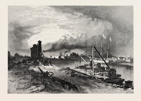
This was the germ of the Seaway process. As the 20th century progressed, Canada and the USA began to mull over the idea of taming a troublesome stretch of the St Lawrence to the south-west of Montreal - using canals, locks and deep-dug channels to swerve around rapids and shallow sections. But while a perfectly good concept in theory, it took a while for it to take root in practice. In 1932, the two countries signed a "treaty of intent" that was meant to look into the possibilities of construction - but this became bogged down in bureaucracy. In 1941, talks between President Roosevelt and the Canadian Prime Minister William King saw the birth of an executive agreement that did not make it past the US Congress. It wasn’t until the early Fifties, and irritated mutterings from Canada that it would start work by itself, that the US formally committed to joint action. On May 13 1954, President Eisenhower inked his name on the Seaway Act, which consented to the creation of the St Lawrence Seaway Authority - and gave it a "mandate to acquire lands for, [and] construct, operate, and maintain a deep draft waterway between the port of Montreal and Lake Erie, along with the international bridges that cross it and other lands and structures." The game was on.
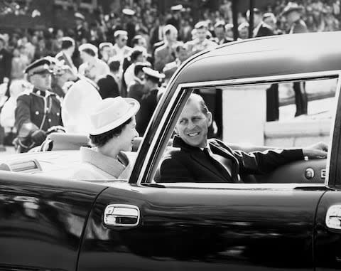
If the many conversations to get there had been torturous, then the execution of the plan was (comparatively) swift. Ground was broken at Massena, on the American side of the St Lawrence (in New York state), on August 10 1954. And seven locks were forged in under five years - the most north-easterly at Saint-Lambert, on the opposite side of the river from Montreal (although still in Quebec); the most south-westerly some 117 miles upstream in Iroquois, on the Ontario side of the currents. The noise of the final bolt being hammered into place was also the sound of a portion of the continent shifting into a new era. By April 25 1959, the Queen (as Canada's head of state) and Eisenhower were enjoying passage down these newly quelled waters on the Royal Yacht Britannia - the first passengers to check what an investment of C$470m (£270m) could produce.
For a while, the Seaway altered the commercial landscape of North America. Ships laden with grain from the fields of the Midwest and the breadbasket states would power north-east, their cargoes destined for Europe. It was certainly a death knell for the Erie Canal - which, running 363 miles west-to-east across the torso of New York state, had connected Lake Erie to the River Hudson at Albany (and with it, to the Atlantic in New York City) since its completion in 1825. Shorn of its main raison d'etre, it would surrender to obscurity. Half a century on, it is mainly used by tourists and recreational boaters, who slip through its 36 locks on warm summer days.

Here in 2019, the St Lawrence Seaway has also, probably, seen better days. Though it is still a major commercial route, its significance has declined as South America and Asia have grown in importance for US and Canadian grain exporters - ships cast off from ports on the west coast and the Gulf of Mexico, rather than in Michigan or Quebec.
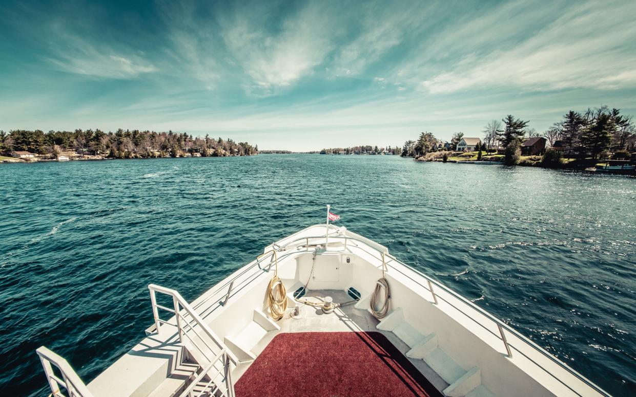
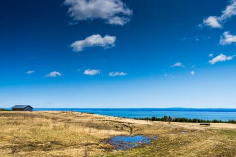
But it remains a remarkable piece of ingenuity. And it retains a beauty too. A large section of the Seaway is forced to meander its way through the Thousand Islands - the innumerately-titled archipelago of tiny outcrops which dots the river between the Canadian city of Kingston, at the north-eastern end of Lake Ontario, and the long finger of Grenadier Island some 50 miles downstream, on the Canadian side of the flow. There are, at official count, 1,864 of these islets, and they are a thing of joy on a hot afternoon, sunlight bouncing off the shallows around them. Should you find yourself travelling this way, you can glimpse some of North America's loveliest scenery, and some of its cleverest mid-20th century thinking, in happy harmony.
Three ways to see the St Lawrence Seaway
Cruise
The Thousand Islands lend themselves to exploration at a leisurely pace. Ontario-based St Lawrence Cruise Lines (stlawrencerivercruise.com) mines their appeal with regular voyages. It even has a "Seaway 60th Anniversary Cruise" scheduled to depart from Quebec City next month (on May 18) - a seven-day affair that will sail all the way to the mouth of Lake Ontario, via Montreal and Kingston. From C$2509 (£1,442) per person (not including international flights).

Road
America As You Like It (020 8742 8299; americaasyoulikeit.com) offers a 12-night "Wonders of Upstate New York" road trip which ventures north from the Big Apple, tracing the Hudson Valley, then cutting across to the St Lawrence for lingering views of the Thousand Islands. From £1,202 per person - including flights, car and hotels.
Boat
It is not entirely the same thing, but the Rideau Canal gives a taste of life on the St Lawrence Seaway. This 1832 relic runs 126 miles south from the Canadian capital Ottawa, connecting with the St Lawrence at Kingston. It makes a splendid setting for a genteel break at the controls of your own vessel. Le Boat (023 9427 0559; leboat.co.uk) can arrange such breaks. A seven-night holiday, boarding a Horizon 4 (which can sleep nine passengers in four cabins) at Smiths Falls (midway down the canal) on June 22, starts at £2,993 in total (not including flights to Canada).

