The eras tour: What past hurricanes tell us about dangers for 2023 season
Like all great artists, the weather is constantly reinventing itself, dividing mystical time into distinctive eras for us mere mortals. It can’t stop, won’t stop moving. It breaks and burns and ends and begins again, a nightmare dressed like a daydream.
The good news is that while hurricane season is wild and crazy, just so frustrating, there is also no sign that it is about to play its ACE (Accumulated Cyclone Energy) in the short term.
There's now only one system to watch in tropics, but little threat
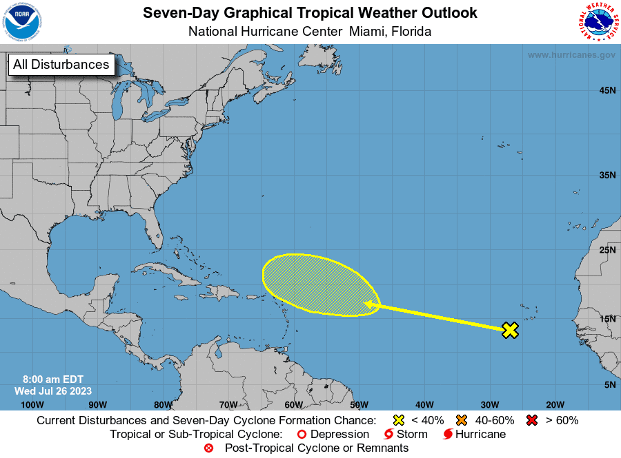
Three disturbances were out there Tuesday; none were worth starting big conversations. By Wednesday morning, the number dropped to one.
The first, a tropical wave in the east-central Caribbean, became undone due to shear en route to Central America.
The second was a system of disorganized storms approaching the northwest Bahamas. While there is no indication of further development, it may cause some full-on rainstorms in Florida Thursday and Friday as it nears the Southeast coast.
The final disturbance, a tropical wave in the eastern Atlantic, has the best potential for slow development. Long story short, this system will move west-northwest into a region of more favorable upper-level winds, and a tropical storm may form east of the Lesser Antilles by early next week.
However, a dwindling, mercurial high in the Western Atlantic entering August means that anything that develops should turn into the salt air of the open Atlantic.
What 101-degree water near the Keys and an analysis of the hurricane eras tell us
Unfortunately, we’re not out of the woods yet.
In next week’s refreshed hurricane season outlook, I’ll discuss how the forecast continues to be a delicate balance, walking a very thin line between unfavorable El Niño and favorable Atlantic conditions. Atlantic sea surface temperatures (SSTs) need to calm down but show no sign of doing so, remaining 2 to 4 degrees above average. A buoy near the Florida Keys even recorded a water temperature of 101.1 degrees.
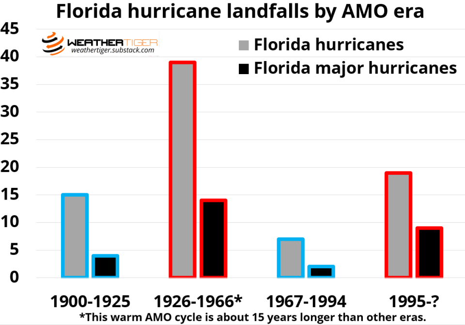
This is important, because hurricane history shows that Atlantic temperatures are the master of spin for entire generations of storm activity. While conditions vary from year to year, there is also a 20- to 40-year cycle of warming and cooling of Tropical Atlantic waters called the Atlantic Multidecadal Oscillation (AMO).
When the AMO is negative, the Atlantic is cooler than average, and there are fewer landfalls compared to when everything has changed and the Atlantic is warm. The influence of AMO cycles is particularly pronounced in Florida, where hurricane landfalls are twice as common and major hurricane landfalls three times as frequent in warm versus cool AMO phases. Activity jumps, then falls. It’s really something.
A tour of the hurricane eras
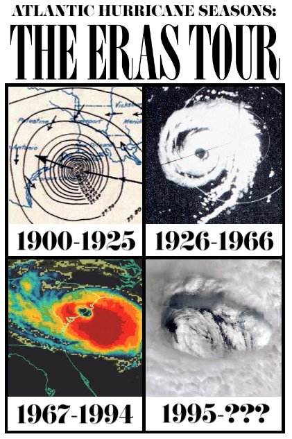
While dealing with storms is never simple, never easy, a tour of the distinct eras of hurricane history contains difficult but real lessons for the season ahead.
1900?-1925: A State of Grace
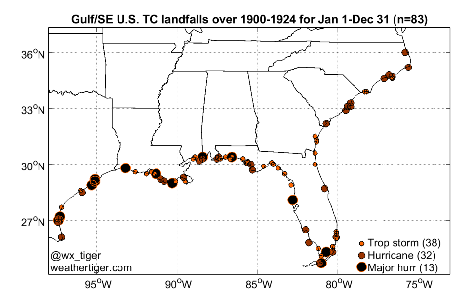
Climatology is a little spotty in the early 20th Century; there were probably more storms than meteorologists know about, but we just can’t prove it. However, enough people lived in saltbox houses on the coast to have a reasonably complete record of U.S. landfalls in the 1900s and 1910s.
We’re confident that the Atlantic was cool and these years were generally quiet, with some exceptions like the 1900 Galveston hurricane. Still, there were only two U.S. Category 4 hurricane landfalls between 1901 and 1925. Florida saw just four category 3+ landfalls, none of which ever, ever, ever struck the rapidly developing East Coast. Next chapter.
1926-1966: So Mean
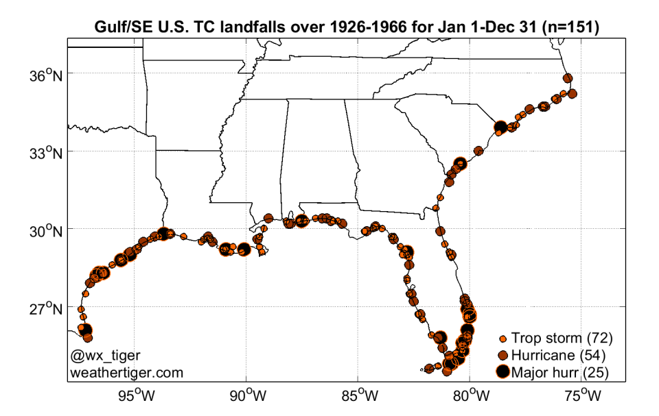
Atlantic SSTs swung wildly warmer in the mid-1920s, and the Great Miami Hurricane of 1926 was the start of four decades of warm AMO and record frequency of hurricane landfalls. Destructive storms like the Long Island Express, Hazel, and Betsy struck across the U.S. coast, but Florida was particularly ravaged.
The state averaged almost one hurricane landfall per year and tallied 14 major hurricanes over 1926-1966, primarily in South Florida and the Keys during Septembers (a month of tears).
The Labor Day hurricane of 1935 is still the strongest U.S. landfall on record with maximum sustained winds of 185 mph, and category 4 hurricanes slowly lurched towards your favorite Florida cities in 1928, 1945, 1947, 1948, 1949, 1950, and 1960.
1967-1994: The Best Days
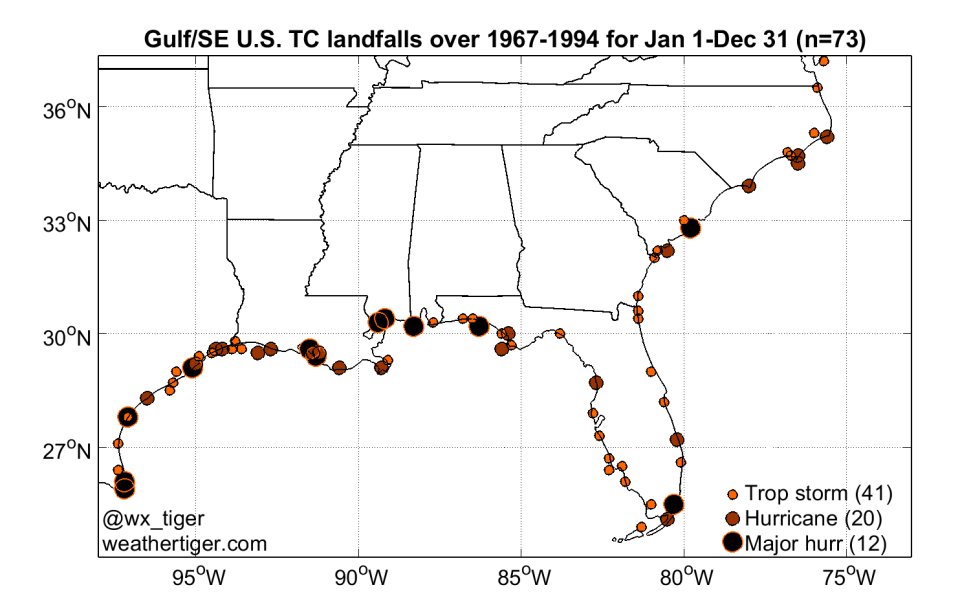
And then in the late 1960s, it was an era of warming. A cold phase with even cooler anomalies than 1900-1925 dominated the Atlantic for almost 30 years, and U.S. hurricane landfall frequency dropped by 40%.
In Florida, we just about forgot that hurricanes existed: there were only seven hurricane and two major hurricane landfalls (unfortunately, Category 5 Andrew among them) in 28 years.
Still, that is as rare as the glimmer of a comet in the sky in historical terms. For most of Florida, let me tell you now, we were the lucky ones.
1995-???: Cruel Summers
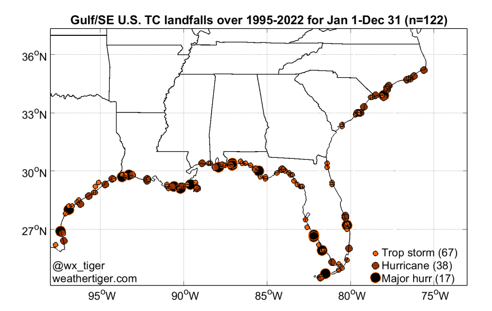
We’ve seen this film before and didn’t like the ending. In 1995, a new (and still-continuing) warm era began as Tropical Atlantic temperatures once again rapidly trended warmer.
That slope was treacherous. Average U.S. hurricane landfall frequency returned all too well to the previous highs of around two per season, eventually bringing some of worst landfalls on record: Katrina, Sandy, Harvey, and Maria.
In Florida, there have been nine major hurricanes in the last 28 years, mostly in the mid-2000s and since 2017, and mostly along the Gulf Coast: Charley, Ivan, Irma, Michael, Ian, and others. Note that compared to the 1926-1966 warm era, the landfall map in South Florida is suspiciously blank space.
Tell me why: Hotter than ever
A hurricane season can always end in burning flames or paradise, usually a little of both.
We don’t know if there will be landfalls this year or how much longer this warm cycle will last, but we do know it’s not ending in 2023 and the overall odds of impacts are higher in this regime. We knew it was trouble when it walked in. It still is. This year’s June AMO index is the highest ever recorded in any month since 1854.
In conclusion, if you fail to plan, you plan to fail. There’s a lot of lame guys out there staring directly at the sun, sitting there by the water, who think it’s all in the past. Playing stupid games, winning stupid prizes.
But hurricane season is a ruthless game: don’t make the moves up as you go. The time to put together your evacuation plan and disaster kit is now, before perfect storms make all the tables turn, ruining everything.
The medium-term forecast is quiet, but these things will change. Are you ready for it? Keep watching the skies (and count how many Taylor Swift song references appear in this column).

Dr. Ryan Truchelut is chief meteorologist at WeatherTiger, a Tallahassee company providing forensic meteorology and expert witness services, and agricultural and hurricane forecasting subscriptions. Visit weathertiger.com to see our real-time seasonal hurricane model predictions and discover how to put our expertise to work for you.
This article originally appeared on Tallahassee Democrat: Florida hurricane forecast: See what history, water temperatures reveal

