Hurricane Eta could hit Nicaragua as a Category 5 before re-entering Caribbean sea
11/3/2020 UPDATE: ‘Extremely severe’ Category 4 hurricane Eta to make Nicaragua landfall soon.
Original article below.
Category 4 Hurricane Eta is rapidly intensifying and could make landfall Tuesday in Nicaragua as a Category 5 storm with more than 150 mph winds.
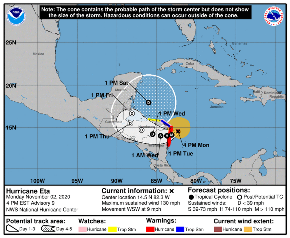
The storm, which reached 75 mph at 4 a.m. Monday, was already a powerful Category 4 hurricane with 150 mph winds by 7 p.m., according to the hurricane center. It maintained its strength as of 10 p.m. and “continued to rapidly strengthen,” forecasters said. There was a chance the storm could intensify even more before it makes landfall, the National Hurrican Center said at 10 p.m.
The storm was about 70 miles south southeast of Cabo Gracias a Dios, a cape that is on the Honduras-Nicaragua border and about 45 miles east of Puerto Cabezas, Nicaragua.
Once it makes landfall, Eta is expected to weaken as it moves over the mountains of Nicaragua and Honduras, but some models show it could restrengthen and enter the Caribbean again as a tropical depression.
“Eta’s surface circulation may not survive its trek over the mountainous terrain of Central America, but most of the global models continue to depict a cyclone over the northwestern Caribbean Sea by later this week and into the weekend which appears to develop from at least a part of Eta’s remnants. Therefore, the NHC track forecast continues to show the system emerging over the northwestern Caribbean late in the period, however the long range portion of the forecast remains quite uncertain,” forecasters wrote.
With Eta, the 2020 hurricane season ties 2005 for most named storms in a season — 28 — and also marks the first time a storm has been named for the seventh letter in the Greek alphabet. In 2005, the hurricane center belatedly classified an unnamed system as a tropical storm, bringing the total to 28 storms even though only 27 were named. Eta is also the fifth storm in a row this season to rapidly intensify, which is when a storm gains at least 35 mph wind speed in 24 hours.
How will Hurricane Eta affect Central America?
Eta is expected to bring life-threatening storm surge, damaging winds, flash flooding and landslides across portions of Central America. Heavy rainfall is also expected, with Nicaragua and Honduras forecast to get the worst of it, with 10 to 25 inches of rain and some isolated areas seeing up to 35 inches of rain.
“This rainfall would lead to catastrophic, life-threatening flash flooding and river flooding, along with landslides in areas of higher terrain of Central America. Flash flooding and river flooding would be possible across Jamaica, southeast Mexico, El Salvador, southern Haiti, and the Cayman Islands,” forecasters wrote.
A dangerous storm surge is also forecast to raise the water as much as 14 to 21 feet above normal tide levels along the coast of Nicaragua that is within the hurricane warning area, and 3 to 5 feet above normal tide levels along the coast of Honduras’ tropical storm warning area.
“Since this is likely to be a very slow-moving system after it makes landfall in Central America, torrential rains and flooding will be a major threat from Eta,” forecasters wrote.
Where is Hurricane Eta going and how strong is it?
On the forecast track, Eta is expected to be a strong Category 4 or 5 hurricane when it make landfall somewhere on the coast of Nicaragua, which is under a hurricane warning from the Honduras-Nicaragua border to the Sandy Bay Sirpi. A hurricane watch is also in effect for the northeastern coast of Honduras from Punta Patuca to the Honduras-Nicaragua border.
The National Hurricane Center predicts Eta will have maximum sustained winds near 150 mph early Tuesday.
The northeastern coast of Honduras from Punta Patuca to the Honduras-Nicaragua border is also under a tropical storm warning and a tropical storm watch is in effect from the northern coast of Honduras from west of Punta Patuca west to Punta Castilla.
The latest forecast by the hurricane center showed Eta weakening drastically over land, but then re-entering the Caribbean as a tropical depression with 35 mph winds on Saturday morning.
Miami Herald staff writer Carli Teproff contributed to this report.

