Evacuation ordered for Volusia beachside as Nicole intensifies; Flagler may order one, too
DAYTONA BEACH — The National Hurricane Center on Tuesday morning issued a hurricane warning for much of Florida's east coast including Volusia County while county officials issued a mandatory beachside evacuation order as Tropical Storm Nicole continued to intensify as it barrels towards the Sunshine State.
The mandatory evacuation order is being issued for beachside areas in Volusia County starting Wednesday morning. Flagler County officials on Tuesday said they may consider issuing one as well.
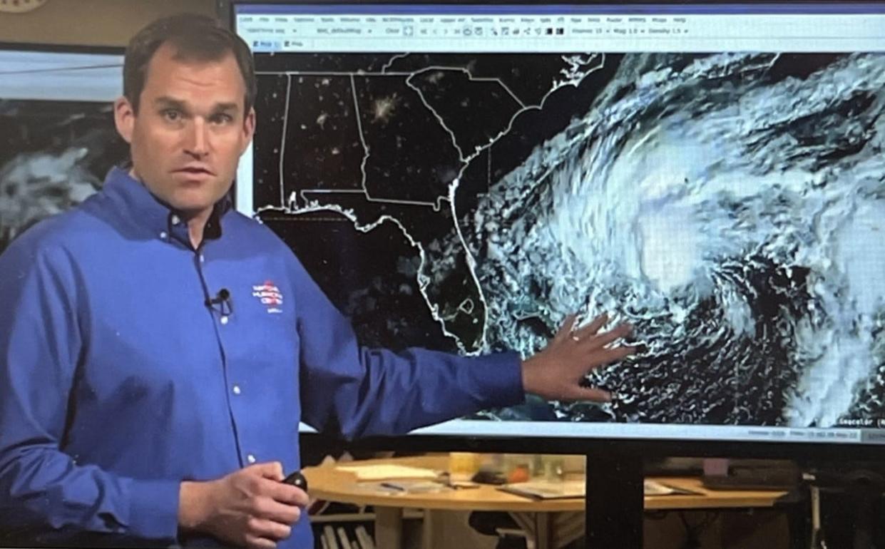
Mike Brennan, the acting deputy director of the National Hurricane Center, on Tuesday morning said hurricane conditions could occur anywhere along the Atlantic coast, from West Palm Beach north to Daytona Beach.
Flagler County is part of the area that is now under a tropical storm warning, according to Brennan who said the affected area stretches from northeast Florida to southeastern Georgia.
Nicole could become a Category 1 hurricane when it makes landfall somewhere on Florida's east coast on Thursday morning, but residents of Volusia and Flagler counties will likely see heavy rains and intensifying winds sooner than that.
"Remember, Nicole has this very, very large wind field, so these tropical storm-force winds are going to move on shore well in advance of the arrival of the center," said Brennan. "So (Tuesday) is really the day to take action along the Florida east coast. Conditions are going to start to deteriorate overnight (Tuesday) and into Wednesday as those tropical storm-force winds move inland."
"In terms of the arrival time of tropical storm-force winds, the be-ready-by time along the Florida east coast is really by (Wednesday) morning," he said.
READ MORE: Volusia, Flagler beaches poised to take another pounding when Nicole hits less than 2 months after Ian
BRACING FOR MORE MISERY: Low elevation makes Daytona's Midtown community prone to flooding during hurricanes, tropical storms
HOPING TO BREAK THE CYCLE: Damage caused by Hurricane Ian raises questions regarding how and where Florida rebuilds after severe storms
Pay attention to entire warning area, not just track
The National Hurricane Center's 10 a.m. Tuesday update on Tropical Storm Nicole included a chart that indicated tropical storm-force winds could reach speeds as high as 90 mph in southeast Volusia County and as high as 80 mph for the rest of Volusia County as well as Flagler County.
"A dangerous storm surge is expected along much of the east coast of Florida and portions of coastal Georgia," according to the NHC forecast. "The storm surge will be accompanied by large and damaging waves."
The NHC forecast reminded Floridians to pay more attention to the entire storm watch area as opposed to the potential path of the storm's center.
The chart showing the predicted track as of Tuesday afternoon appears to indicate that the center of Nicole making landfall near Stuart around 1 a.m. Thursday. Nicole is then expected to continue heading northwest over the Florida peninsula and then curving northeast over the Tallahassee area. Nicole should be somewhere over Georgia by Friday morning.
"It's not just a coastal event," warned Brennan, who said inland areas under the tropical storm watch "could see blowing debris, tree limbs down, you could see some scattered power outages. You could see more substantial wind impacts in the hurricane warning area where we could see tree damage, some damage to roofs (and) more substantial power outages as we go through the next couple of days."
Get ready for more flooding from Nicole
Volusia County was hit by widespread flooding in late September when Tropical Storm Ian swept through the area. Those areas including the communities along the St. Johns River as well as low-lying areas in east Volusia could see more flooding when Nicole hits, according to Brennan. He warned that Nicole could bring as much as seven inches of rain.
"It's not just a wind event, there's a lot of water coming with Nicole," said Brennan. "We have a storm surge warning that's in effect for much of the east coast of Florida, from north Palm Beach all the way up through Cape Canaveral, up through places like St. Augustine, Jacksonville and up to Altamaha Sound, Georgia, including places like the St. Johns River."
Daytona Beach City Commissioner Quanita May represents portions of downtown Daytona Beach as well as the city's Midtown area, both of which saw flooding during Ian. She also represents a portion of the city's beachside.
"Absolutely, I'm concerned," said May of the potential additional flooding that Nicole could bring. "Residents were just starting to clean up. Now Nicole hits."
Several businesses in downtown Daytona Beach got flooded during Tropical Storm Ian, but James Sass, the owner of Abraxas Books at 256 S. Beach St., said he lucked out.
"I somehow got a free pass from Ian, unlike previous Hurricane Irma (in 2017) when I got a foot of water inside my shop and lost 20,000 books," said Sass. "I only had very minimal damage this time around. My front door got water-logged and swelled shut which prevented me from reopening for a few days. I heavily sandbagged my shop and am doing it this time around, too. I've made a point of putting down multiple layers of tarps. My concern with Nicole is how it will affect the Halifax River especially during high tide."
Holly Hill suffered extensive flooding during Ian. More than half of its 4.5 square miles is in a low-lying flood zone.
"There's always a concern of flooding when you're so close to sea level as we are when a major hurricane or tropical storm is coming," said Holly Hill Mayor Chris Via. "But we're doing everything we can. Our city crews are working really hard right now making preparations for the incoming storm and they'll be working around the clock as it comes in and as it leaves us to get things back to normal as soon as possible."
Volusia County officials issue warnings
As Tropical Storm Nicole gained strength Tuesday, Volusia County officials not only announced the mandatory evacuation for some residents but also a countywide curfew. The curfew is slated to begin 7 p.m. Wednesday to 7 a.m. Thursday.
The county will also open four shelters.
Tropical Storm Ian stripped sand from the coast, leaving some properties very vulnerable to further erosion and collapse. Meanwhile, some low-lying areas have only recently seen relief from bloated waterways.
Volusia County's evacuation order applies to all areas east of the Intracoastal waterway, as well as for all manufactured and mobile home residents east of Interstate 95, all low-lying areas, any other areas prone to flooding and all recreational vehicle parks and campsites.
Volusia County officials will decide later when to lift the evacuation order based on conditions, said Jim Judge, the county's interim director of emergency management.
People should avoid returning to the beach or coastal structures, including homes, until county officials provide clearance to return to the area.
County spokesman Kevin Captain said that areas not in the evacuation order could still see widespread flooding or other impacts.
Volusia County Manager George Recktenwald encouraged all residents to take the storm seriously. "This incoming storm is a direct threat to both property and life," he said. "If you live in an area that has been issued a mandatory evacuation order, please follow this order."
Volusia County Sheriff Mike Chitwood said beachside will be "locked down," with no one allowed over bridges to that side unless they're a resident going to pick up supplies.
"This is a real safety hazard to our residents and to our community, so we need you to heed this," Chitwood said. "This is not the time to have hurricane fatigue."
The curfew will not apply to law enforcement, emergency workers or “employees of business, industries or government entities while traveling from their jobs,” he added.
Daytona Beach International Airport on Tuesday afternoon announced that its main terminal building and airfield will close at 12:30 p.m. Wednesday due to Tropical Storm Nicole. All flights after this time are canceled, except for government, emergency, and humanitarian aircraft.
The airport is scheduled to reopen at 4 a.m. Friday. Passengers should check with their airlines for updates to flight schedules.
Volusiounty's coastline took a major hit during Tropical Storm Ian, and countywide the damage tally was over $340 million as of Oct. 31.
County officials will open four shelters starting at 10 a.m. Wednesday: David C. Hinson Middle School at 1860 N. Clyde Morris Blvd. in Daytona Beach and Heritage Middle School at 1001 Parnell Court in Deltona, both of which will serve people with special needs; and Creekside Middle School at 6801 Airport Road in Port Orange and University High School at 1000 W. Rhode Island Ave. in Orange City, both of which will accommodate people in the general population. All shelters are pet friendly.
County officials encouraged people to seek safe housing with family and friends or at a hotel or motel and to use a shelter as a last resort.
Two homeless shelters will open Wednesday: The Bridge at 421 S. Palmetto Ave. in DeLand and First Step Shelter at 3889 W. International Speedway Blvd. in Daytona Beach. People need to first go to Halifax Urban Ministries at 340 N. St. in Daytona Beach to get transportation to the First Step Shelter.
From Geneva to Astor, a flood warning is in effect for the St. Johns River.
The Halifax River could swell two to three feet and people who live on either side of it could have water come over their docks and into their backyards, county officials warned.
The coast in Volusia County on Tuesday afternoon was already seeing large, powerful waves. Nicole will bring even more dangerous conditions, including rip currents.
Some buildings along the coast "are at imminent risk of collapsing," Chitwood warned. "What Ian left us, we have not recovered from."
Volusia County's Emergency Operations Center will be fully activated Wednesday and Thursday with workers ready to respond, including power company crews, Judge said.
Storm updates and preparation information are available at volusia.org/pin. Residents can also call the Volusia County Citizens Information Center at 866-345-0345.
Flagler could also see hurricane conditions
Flagler County Emergency Management Director Jonathan Lord on Tuesday urged residents to prepare for Tropical Storm Nicole, which he warned could become a hurricane by the time it reaches the area.
The county will likely issue evacuation orders on Wednesday for all residents and businesses on the barrier island from Flagler Beach to Marineland as well as at all mobile home parks and RV campgrounds, including those that are inland, he said.
“It is well within the realm of possibility that Flagler County could have a Category 1 hurricane make landfall in or near us,” Lord said.
Flagler County residents could expect to see storm surges three to five feet above normal with waves potentially exceeding 15 feet through Thursday afternoon and possibly into the evening, he said. Countywide winds would be nearing tropical storm force speeds along the coast with the “real possibility” of hurricane force gusts.
Because of previous damage to the coastal-protection dunes by Ian, there is a real risk of dunes being breached, Lord said.
“We really want our residents to realize we don’t take ordering an evacuation lightly,” Lord said. “There is a significant risk to life and property with this storm, particularly along the coastline.”
The county in partnership with the Flagler County School District and the Sheriff’s Office and Health Department will open Rymfire Elementary School at 1425 Rymfire Drive in Palm Coast as an emergency storm shelter at 3:30 p.m. Wednesday.
Residents should bring medicine for five days and any needed medical supplies and equipment, sleeping bags, pillows, blankets, snacks and comfort food and any important documents.
As of Tuesday afternoon, no curfews in Flagler County were planned.
School districts announce storm closures
Volusia County Schools on Tuesday afternoon announced that all public schools and administrative offices will be closed Wednesday and Thursday because of Nicole. All school-sponsored activities are also canceled those two days.
The Flagler County School District will release students at all schools early on Wednesday, said Flagler County Schools Superintendent Cathy Mittelstadt. Elementary school students will be dismissed at 2 p.m., middle school students at noon and high school students at 1 p.m. Schools will be closed on Thursday.
Schools in both Volusia and Flagler counties were already set to be closed on Friday in observance of Veterans Day.
News-Journal reporters Frank Fernandez, Sheldon Gardner and Danielle Johnson contributed to this report.
This article originally appeared on The Daytona Beach News-Journal: Volusia County prepares for Nicole's wrath under hurricane warning

