Oak Fire live update: Wildfire ‘moving fast,’ jumps road and now threatens structures
THE LATEST: ‘Explosive fire behavior,’ structures destroyed
A fast-moving wildfire near Yosemite National Park quickly spread in the mountainous terrain of Mariposa County threatening to destroy more than 1,000 structures going into late Friday night.
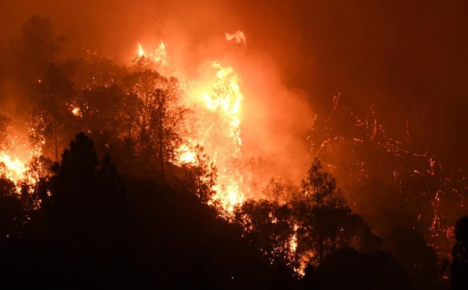
All the while, crews had not yet established any type of containment early on against the Oak Fire that had been burning since 2:10 p.m. and grown to nearly 7 square miles within the first nine hours.
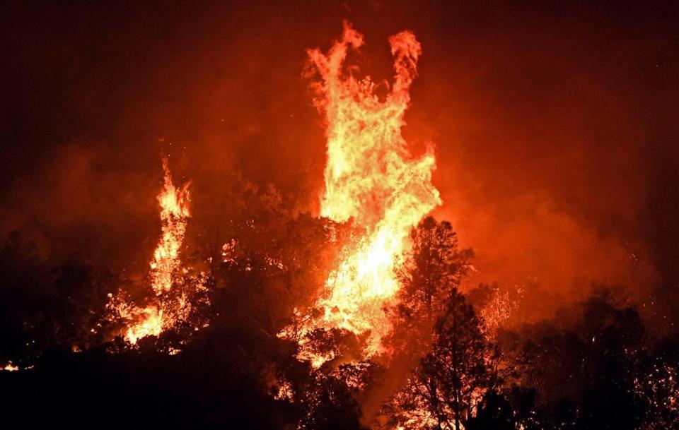
At least one mountainside looked completely ablaze.
“Fire activity is extreme with frequent runs and group torching,” Cal Fire provided in its situation summary. “Vegetation is very receptive to new spot fires due to the hot, dry weather and drought.
“Heavy fuels, strong winds and low humidity are also influencing fire behavior.”
Natural barriers in the area hadn’t yet helped slow the fire, either.
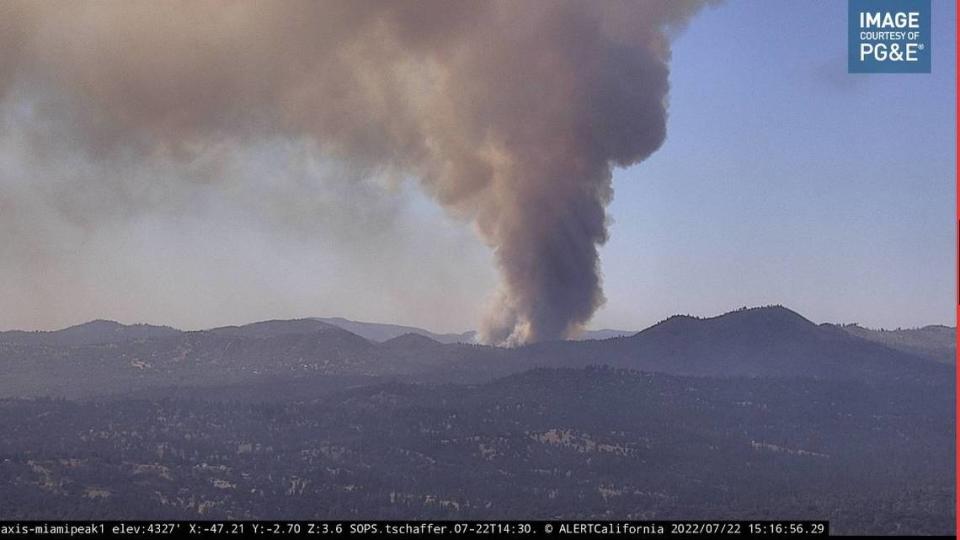
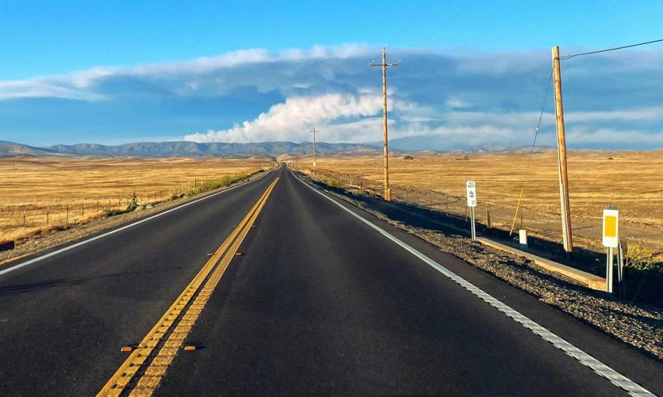
And the Oak Fire became so big and grew so fast, a pyrocumulus cloud formed and could be seen more than 120 miles away from the Bay Area. Smoke also could be spotted from outer space.
All the while, the wildfire burned on roughly 12 miles southwest of Yosemite National Park’s Arch Rock entrance on Highway 140 and about 12 miles northwest of the national park’s south entrance off Highway 41.
Cause of the Oak Fire remained under investigation. It’s the third wildfire to erupt this month near or inside Yosemite.
“We’ve been through so many fires, and it’s still shocking,” Oakhurst resident Rhonda Beams said. “This one feels worse than the others.”
From the 6-hour #timelapse #OakFire began near 2pm Pacific Time and has already reached over 23,000 feet plus over-shooting tops.@nvfirecams @alertwildfire #AxisEdith via @NVSeismoLab #CAwx pic.twitter.com/zA0s3ksNU1
— NWS CWSU Oakland (@NWSCWSUZOA) July 23, 2022
‘From bad to worse’
The Mariposa County Public Information Twitter account sent out a tweet Friday evening that described the Oak Fire activity as going “from bad to worse.”
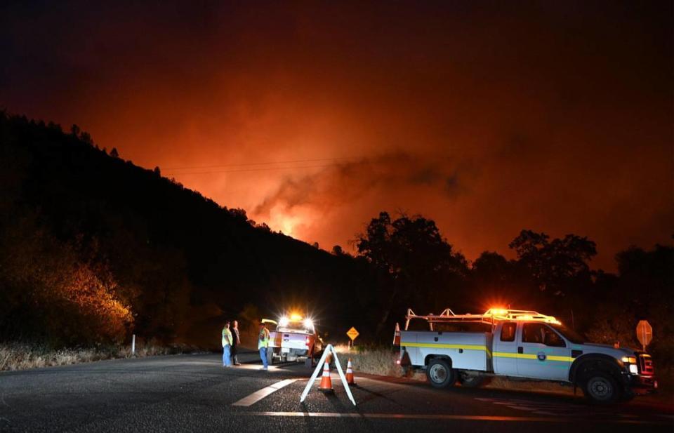
At around 9:30 p.m., the Oak Fire jumped Triangle Road and Silva Road, and threatened 50 to 100 structures.
Five additional strike teams of engines were requested to help contain the fire as it spread south.
The Mariposa County Sheriff’s Office ordered multiple areas to evacuate, including the Lushmeadows community, which is considered one of the most densely populated communities in Mariposa. Many homes in that community were placed on 2-acre plots, as opposed to other rural homes in the area with lands that often stretched much farther.
Cal Fire’s update at 11 p.m. stated that the Oak Fire had grown to 4,350 acres with 0% containment and threatened 1,303 structures.
Sabrina Geforos, who was one of many Mariposa residents were forced to evacuate from their homes, expressed fear and nervousness while trying to monitor the Oak Fire’s behavior into the night.
“Now, we pray our house survives,” Geforos said, “and pray people don’t lose their homes.”
According to Assemblyman Jim Patterson, R-Fresno, firefighters continued to work to help people get out of the area and save homes.
#OakFire This went from bad to worse... Lushmeadows community is being evacuated. This is one the most densely populated communities in Mariposa. #MariposaCounty
Map Link:https://t.co/8CgcYaJcuV https://t.co/pqrXexmJJb pic.twitter.com/3MkSg9hdDm— Mariposa Co. GIS (@MariposaCo_GIS) July 23, 2022
Latest evacuation orders
The Mariposa County Sheriff’s Office issued more evacuation orders around 9 p.m.
Here are the areas that were advised to evacuate immediately:
Carstens Road
Buckingham Mt. Road
Plumbar Creek Road
Triangle from Highway 140 to Darrah
Jerseydale and all side roads
Lushmeadows Subdivision Triangle Road from Darrah Road to Westfall and all side roads
Boyer Road from Highway 49S and all side roads
Darrah Road from the stop light to Triangle Road
Triangle Road from 49S to Westfall Road and all side roads, including Triangle Park
Tip Top Road
Wass Road
Westfall from Triangle to Oliver Creek
In addition, there have been road closures at:
Highway 140 from Allred Road to Ponderosa Way
Carstens Road
Triangle Road from Highway 140 to Highway 49 and all side roads
Buckingham Mt. Road
Plumbar Creek Road
Jerseydale Road
Silva Road from Cole Road and Triangle Road
Wass Road
Tip Top Road
Darrah at Cole Road
Westfall from Triangle to Oliver Creek
Evacuation centers are established at the Mariposa Elementary School located at 5044 Jones St. in Mariposa and Sierra Foothill Charter School at 4952 School House Road, Catheys Valley CA 95306.
Those evacuating large animals were advised to go to the Mariposa Fairgrounds.
And those evacuating small animals were to go to the Mariposa Elementary School.
Oak Fire forms pyrocumulus cloud
The fire, which ignited around 2 p.m., had grown so big in such a short amount of time that a pyrocumulus cloud formed and could be seen more than 120 miles away from the Bay Area.
From the 6-hour #timelapse #OakFire began near 2pm Pacific Time and has already reached over 23,000 feet plus over-shooting tops.@nvfirecams @alertwildfire #AxisEdith via @NVSeismoLab #CAwx pic.twitter.com/zA0s3ksNU1
— NWS CWSU Oakland (@NWSCWSUZOA) July 23, 2022
Dr. Crystal Kolden, a pyrogeographer and a professor at UC Merced, said the pyrocumulus cloud was a result of smoking rising “until it hits the upper level winds, stalls, and then suddenly punches through.”
The smoke cloud from the Oak Fire became so big, in fact, it could been seen from outer space via a camera on the NASA international space station.
Northern California Wildfire(s): This is the view at 6pm tonight from the @Space_Station. #OakFire looking quite a monstrous thing down there. Heartbreaking to witness. #ThanksToFireFighters@NWSBayArea @NWSHanford @kcranews @ABC10
Jul 22, 2022 pic.twitter.com/5XUds1q6PN— ISS Above (@ISSAboveYou) July 23, 2022
Kolden, who studies wildfire, added that the Oak Fire was expanding due to three primary factors: fuel load, heat and the very dry air due to a 108-degree day.
The professor said the area hasn’t burned since 1924.
#OakFire is blowing up rn due three main factors: fuel load, heat, and very dry air (relative humidity). 108F today, RH only rose to 35% last night and was 5% at El Portal an hour ago. Area hasn't burned since 1924 per https://t.co/Xle0LioiNN pic.twitter.com/t9gzjx7MH5
— Dr. Crystal A. Kolden (@pyrogeog) July 23, 2022
As of 7:23 p.m., Cal Fire reported that the Oak Fire remained at 0% containment.
Cal Fire announced at 8:10 p.m. that Incident Management Team 5 was activated to the Oak Fire.
The IMTs are made up of trained personnel who provide operational management and support to large-scale, expanding incidents.
CAL FIRE Incident Management Team (IMT) 5 has been activated to the #OakFire in the @CALFIREMMU. IMT’s are made up of trained personnel who provide operational management and support to largescale, expanding incidents. pic.twitter.com/iA5e1qlLPG
— CAL FIRE (@CAL_FIRE) July 23, 2022
Evacuating with animals
Amid the rush to pack important belongings and other essential items after evacuation orders were issued, many residents in the mountainous areas of Mariposa County also had to quickly game plan how to get their livestock and pets to safety.
Like 61-year-old Sabrina Geforos, whose home on 14 acres of land suddenly was threatened as the Oak Fire spread southward late Friday night.
She had two rescue donkeys that needed to be hauled in a trailer to the Mariposa Fairgrounds, in addition to three goats and two dogs.
“It’s stressful,” Geforos said. “Those rescue donkeys don’t load well. They’d never been in a trailer except once before and they don’t like being in there.”
Geforos and her husband eventually got some assistance from nearby friends to load the donkeys.
But it took 20 minutes.
And then there still was the drive to the fairgrounds.
“When they tell you that you need to evacuate, every minute seems to go by so quickly,” Geforos said. “So 20 minutes feels like you’re spending too much time on that because you’re know there are other things, too, you got to get before it’s too late.”
As soon as Geforos helped unload the donkeys at the fairgrounds, she rushed back home to put her dogs in crates and load up her goats.
“I can tell you it’s the most dreadful thing,” Geforos said, “to think you’re leave behind your home and you still have your animals there and you don’t know if you get them back.”
A friend’s photo of hers and others’ evacuated animals. They’re soooo cute!! Please consider donating to Mariposa Fairgrounds. They are extremely important to the community! https://t.co/APvQahVouk #OakFire pic.twitter.com/b8BPi4Ihvl
— Lynx (@LibertyLynx) July 23, 2022
Geforos eventually got all of her animals to safety, though she wondered how her animals were handling their new, temporary environment.
“I saw other people arriving in two big horse trailers,” Geforos said. “I believe I saw a lama and some alpaca there. I’m sure my goats are freaking out.
“At least they’re not near the fire.”
Nonetheless, the stress of transporting her animals led to Geforos to forget a few things.
Like her hairbrush and toothbrush.
“When you drive away from your home in a situation like this, you have to say to yourself ‘Everything else left behind, it’s just stuff,’ ” Geforos said. “ ’I hate to lose any of it. But it’s just stuff.’
“My animals are saved; my husband and I are safe,” Geforos added. “Now, we pray our house survives and pray people don’t lose their homes.”
Early reports, where Oak Fire started
The Mariposa County Sheriff’s Office has issued evacuation orders due to a wildfire that erupted Friday afternoon in the Midpines area.
The vegetation fire, which has been named the Oak Fire, started just after 2 p.m. on Friday near Carstens Road and Highway 140, just north of Mariposa and not too far from Yosemite National Park.
Cause of the fire remains under investigation.
The areas being evacuated at this time include: Carstens Road, Buckingham Mt. Road and Plumbar Creek Road, Triangle from Plumbar to Highway 140, Jerseydale and all side roads, according to the Sheriff’s Office.
Highway 140 is closed between Carstens Road and Allred Road in Midpines, Caltrans reported. The Yosemite South gate is open to allow people out of the park because of the closure near Midpines, park official said.
The fire burned 611 acres as of 4:45 p.m. Friday, according to Cal Fire, but grew to 1,300 acres as of 5:40 p.m.
An evacuation center had been established at the New Life Christian Church, located at 5089 Cole Road in Mariposa.
Just after 5 p.m. Friday, however, the Red Cross tweeted out the evacuation center was moved to Mariposa Elementary School, 5044 Jones Street in Mariposa.
#Oakfire Form wawona YNP pic.twitter.com/EHE2NR1wut
— Mark Ruggiero (@markfire) July 23, 2022
Pretty incredible that we could briefly see the Pyrocumulus cloud from the #OakFire at our office here in northern Reno (middle part of first picture). The fire broke out this afternoon west of Yosemite in Mariposa county. We are approximately 120 north of the fire! #cawx #nvwx pic.twitter.com/84GNnd4vvs
— NWS Reno (@NWSReno) July 23, 2022
Some users on Twitter reported being able to see smoke from the fire, as far away as Ceres.
The Oak Fire is the third wildfire to erupt this month in Mariposa County.
The Washburn Fire has burned 4,856 acres and is 79% contained, according to the Yosemite National Park. And the Agua Fire has burned 412 acres and is 89% contained, according to Cal Fire.
#OakFire new shelter location: An evacuation shelter is open at Mariposa Elementary School (5044 Jones Street, Mariposa, CA 95338) for evacuees affected by the Oak Fire in Mariposa. Red Cross volunteers will provide safe shelter, water, meals and additional resources to evacuees. pic.twitter.com/O4zTDVwajw
— Red Cross Central California (@RedCrossCCR) July 23, 2022
#TrafficAlert
SR-140 currently is closed between Carstens Road and Allred Road in Midpines (Mariposa County) due to the Oak Fire. For more information: https://t.co/XDM49zDsCb.
For road information, check https://t.co/7koCcoZm3Z.
Please avoid the area! pic.twitter.com/NDonubqLre— Caltrans District 10 (@CaltransDist10) July 22, 2022

