Alpine snow, more heavy rains washing into B.C. through Sunday

Bouts of heavy rain washed into British Columbia on Saturday as a hefty Pacific storm focused its energy on the West Coast. Rainfall totals of 100+ mm are possible in spots through the weekend, along with blustery winds and a threat for hefty alpine snows.
MUST SEE: Canada's November outlook: A smooth transition or a free fall into winter?
Prepare for difficult travel in the hardest-hit areas, as well as the chance for power outages in areas expecting high winds this weekend.
Feisty storm spends a weekend visiting B.C.
The low-pressure system affecting B.C. this weekend will produce widespread heavy rain as it taps into an atmospheric river funneling subtropical moisture into the region.
Unlike the storm we saw earlier in the week, milder temperatures will keep snow confined to higher elevations and some of the mountain passes.
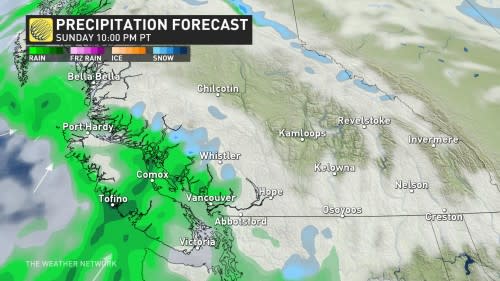
Rounds of heavy rain will continue across Vancouver Island, the coastal mountains, and the Lower Mainland through the overnight and into Sunday.
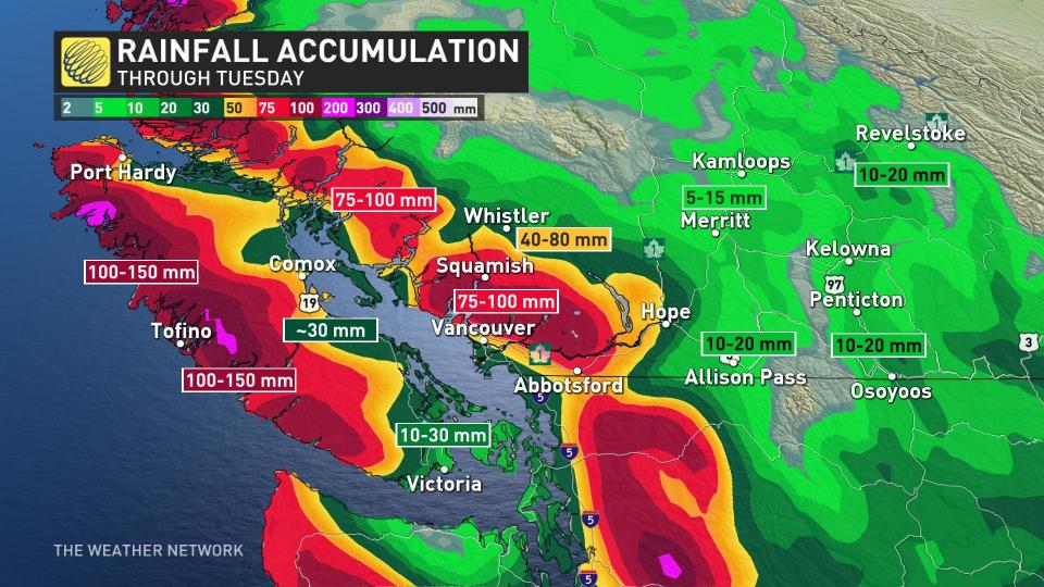
We’ll see the heaviest rainfall totals over western Vancouver Island and in the mountains, where storm totals of more than 100+ mm are expected. Some areas in the mountains could even approach 200 mm.
Much lighter totals are expected in the typical rain shadows of Victoria and Saanich, where 20 mm of rain is expected in the provincial capital. Higher amounts are likely as you head up Highway 19, with about 30 mm expected from Nanaimo to Campbell River.
SEE ALSO: Canada’s cold air brings Mexico some of Earth’s most violent winds
Metro Vancouver and the Lower Mainland will see varying amounts, with lower amounts closer to the airport and higher rainfall totals farther north and east. The heavy rainfall will likely lead to a rise in river levels across the area, and the rains could lead to localized ponding and pooling on roadways.
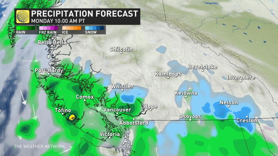
Mild ocean air will continue to replace colder air across the region, pushing the risk for frozen precipitation farther into the Interior, east of Kamloops, Kelowna, and Osoyoos.
Eagle Pass, Rogers Pass, and Kootenay Pass will likely see accumulating snow through the weekend. Travellers planning to head through these regions should prepare for slick roads and slow going.
Winds will pick up as the system moves into the region, as well. Haida Gwaii and the northern coasts of Vancouver Island will likely see gusts of 70-90 km/h through Saturday afternoon.
Environment and Climate Change Canada (ECCC) issued a wind warning for coastal sections of northern Vancouver Island ahead of the storm. "Loose objects may be tossed by the wind and cause injury or damage. High winds may result in power outages and fallen tree branches," ECCC said in its warning.
Unsettled weather is likely to continue through early next week before a spell of drier weather takes hold. Forecasters see an active pattern resuming by the end of next week and into the following weekend.
Stay tuned to The Weather Network for the latest on conditions across B.C.

