'Exercise caution': Perilous travelling expected in Ontario snow squalls
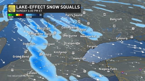
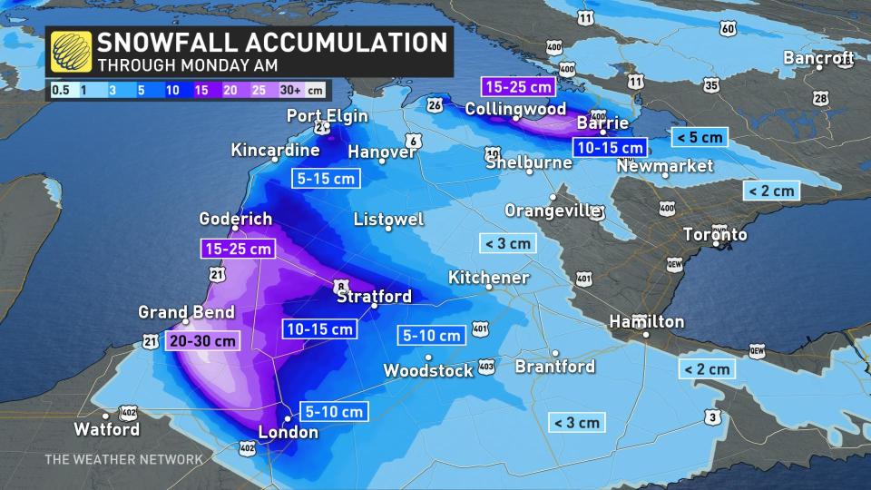
Heads-up if you are planning on travelling to communities near Lake Huron and Georgian Bay Sunday: Snow squalls are likely to create hazardous conditions on the road, with potentially up to 30 cm of snow possible in the heaviest bands. When combined with blustery winds, visibility will be quite poor and roads will be slippery.
DON'T MISS: Why snow squalls are one of the hardest events to forecast
Sunday: Cold moves in and brings the snow with it
Sunday is shaping up to be the region's most significant snow squall event of the season to date. Snow squall watches and warnings are in place. As the morning progresses, the lake-effect snow machine will be turned on thanks to steady, northwesterly winds over the relatively warm lake waters.
Temperatures steadily dropped into Sunday morning, allowing for most areas to see a precipitation transition to flurries.
On Sunday morning, lake-effect bands will become more pronounced off of Lake Huron and Georgian Bay as winds align, allowing for steady snowfall for communities southeast of lakeshores.
Heaviest snow within these bands is expected to fall around noon hour, with rates of 2-4 cm an hour expected, so anticipate near-zero visibility. The hardest-hit areas could locally see 15-30 cm of snow. Conditions will change rapidly over short distances beneath snow squalls, potentially catching drivers by surprise when visibility drops to near-zero in spots.
"Snow squalls cause weather conditions to vary considerably; changes from clear skies to heavy snow within just a few kilometres are common. Visibility may be suddenly reduced at times in heavy snow. Travel is expected to be hazardous due to reduced visibility in some locations. If visibility is reduced while driving, turn on your lights and maintain a safe following distance," says Environment and Climate Change Canada (ECCC) in the snow squall warning.
It never hurts to take it slow and consider changing non-essential plans in areas expecting heavy snow. Blowing snow will reduce visibility even in areas where snow isn’t falling at the time.
Some of the squalls could grow potent enough that we might see flurries poke into parts of the Greater Toronto Area and 400-series highways. While no accumulations are expected here because the ground is still warm, it'll serve as a reminder that winter is indeed on its way.
The flurries and snow squalls will persist through Sunday overnight before weakening through the day on Monday.
Toronto on the cusp of notching latest freezing temperature on record
It’s not every year that Oklahoma City and Greensboro, North Carolina, reach the freezing mark before Toronto, but this year’s topsy-turvy pattern across North America allowed each of those cities to drop to or below freezing before Canada’s largest city.
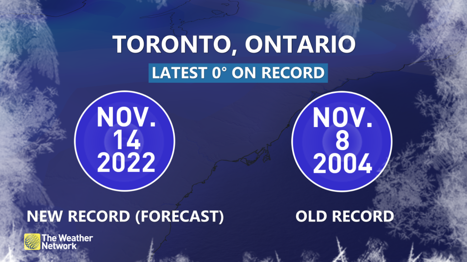
Toronto’s historic streak of above-freezing temperatures will soon come to an end with the pattern change allowing for snow squalls across southern Ontario.
The previous record for Toronto’s latest 0°C reading occurred on November 8, 2004. It looks like we’re on track to finally hit the zero-degree mark on Monday morning, breaking the old record by almost a week.
Cold continues, more snow for this week
Widespread colder than seasonal conditions are set to dominate this week and beyond, with another reinforcing shot of Arctic air and temperatures more typical of early December at times.
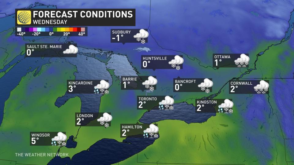
This should bring additional lake-effect snow to the traditional snowbelt areas east and southeast of the Great Lakes starting Wednesday, with more squalls continuing next weekend. Localized snow totals will be rather impressive.
DON'T MISS: Icy weather is inevitable. Here's what you need to prepare
We’ll see the potential for the first widespread coating of snow of the season Tuesday night and Wednesday for eastern Ontario, and possibly parts of the south. Typical of mid-November events, temperatures will be marginal with accumulations highly impacted by elevation and distance from the Great Lakes.
Be sure to check back for the latest weather updates across Ontario.

