Expect peak snowfall Tuesday morning in Sioux Falls, according to NWS meteorologist
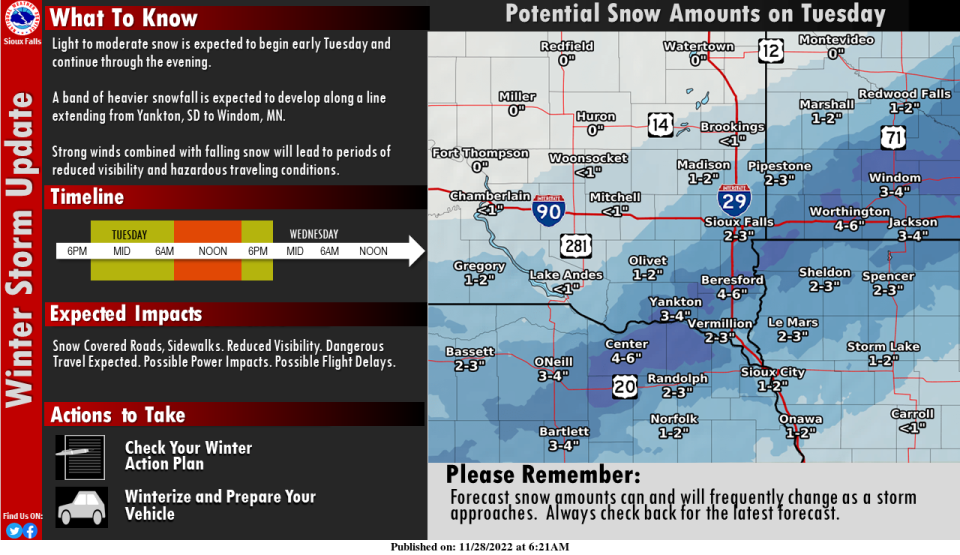
Sioux Falls is expected to see the first significant impacts from winter weather this season during Tuesday morning's rush hours, according to the National Weather Service of Sioux Falls.
Weather forecasters predict 1-4 inches of snowfall throughout the immediate Sioux Falls area, starting Monday night. Sioux Falls residents can expect peak snow from 5 a.m. to 11 a.m. Tuesday, said NWS of Sioux Falls meteorologist Jeff Chapman.
Wind gusts of 30 - 35 mph are expected to develop Tuesday morning and into the afternoon. Chapman advises drivers to anticipate reduced visibility and to drive carefully through the changing conditions.
"Slow down and allow extra time between your vehicle and others," said Chapman. "This is the first system that will bring fairly significant impacts as far as driving."
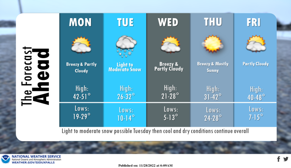
Temperatures will drop to a low of about 10 degrees Tuesday night and highs will sit in the low 20s on Wednesday, said Chapman.
"With wind and cold temperatures, we will be looking at below zero wind chills at times all the way into Thursday morning," Chapman told the Argus Leader.
The NWS has issued a winter weather advisory from 6 a.m. to 6 p.m. Tuesday. They've also advised drivers to expect slippery road conditions, patchy blowing snow that could reduce visibility and hazardous conditions impacting the morning or evening commutes.
More: Sioux Falls could see more than 2 inches of snow Tuesday, NWS says
Sioux Falls weather forecast: Snowfall, wind gusts start Monday night
Here's a more detailed look at weather forecast through the week as of 10 a.m. Monday:
Monday: Mostly sunny, with a high near 46. South wind 5 to 15 mph becoming northwest in the afternoon. Winds could gust as high as 20 mph.
Monday night: Snow, mainly after 4am. Low around 25. North northeast wind 5 to 10 mph. Chance of precipitation is 80%. New snow accumulation of less than a half inch possible.
Tuesday: Snow, mainly before 3 p.m. Temperature falling to around 24 by 11 a.m. Blustery, with a north northwest wind 10 to 20 mph, with gusts as high as 30 mph. Chance of precipitation is 90%. New snow accumulation of around 2 inches.
Tuesday night: Mostly cloudy, then gradually becoming mostly clear, with a low around 13. Northwest wind around 15 mph, with gusts as high as 30 mph.
Wednesday: Sunny, with a high near 23. West northwest wind 10 to 15 mph, with gusts as high as 30 mph.
Wednesday night: Mostly clear, with a low around 9. West wind 5 to 10 mph becoming southeast after midnight.
Thursday: Mostly sunny, with a high near 34. Breezy.
Thursday night: Partly cloudy, with a low around 27.
Friday: Mostly sunny, with a high near 43.
Friday night: Partly cloudy, with a low around 12.
Saturday: Sunny, with a high near 26.
Saturday night: Partly cloudy, with a low around 17.
Sunday: Mostly sunny, with a high near 39.
This article originally appeared on Sioux Falls Argus Leader: Sioux Falls to see wind, snow Tuesday morning, NWS forecasts

