Winter weather advisory in effect, snow in northern Ohio Wednesday morning
A winter storm is coming. And it looks like there's no avoiding this one in northern Ohio.
The National Weather Service says this will be an equal opportunity storm with widespread snow across northern Ohio starting late Tuesday night into Wednesday morning.
"The hazardous conditions could impact the morning commute," the weather service warns.
Driving tips:Driving in northern Ohio this winter? These tips will help you get there safely
After that things get tricky in northern Ohio as some ice might mix in before switching to rain in some areas and then snow again by Wednesday night.
The weather service has already issued a winter storm warning for extreme western Ohio and a winter weather advisory for all of northern Ohio.
Support local journalism. Subscribe to the beaconjournal today to access all of our content online at cm.beaconjournal.com/specialoffer.
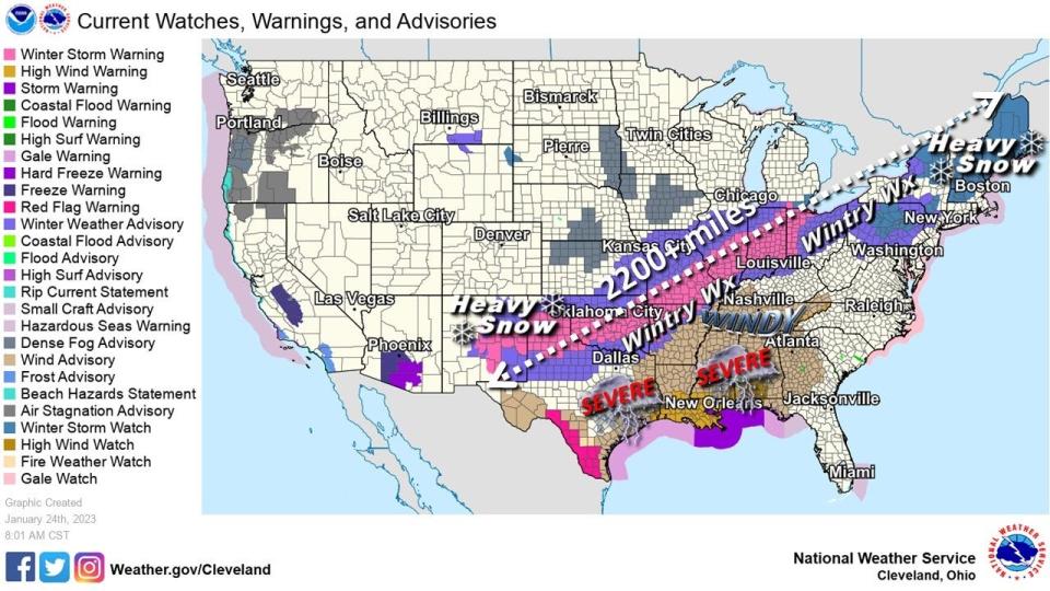
This storm is a monster stretching some 2,200 miles from New Mexico to Maine.
When will the storm start?
The snow is expected to start around 3 a.m. Wednesday morning and continue through the morning hours. It is expected to switch over to a wintery mix by the afternoon and then rain through the evening. By 2 a.m. Thursday morning, it switches back over to snow. The weather service says snow showers are expected Thursday and continuing through Friday.
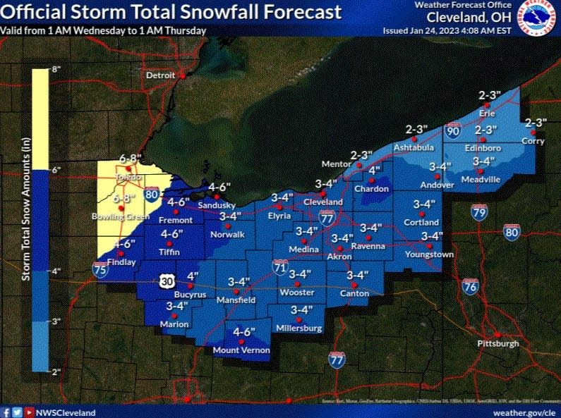
How much snow is expected in Akron?
Snowfall rates of an inch an hour are possible around the region for the Wednesday morning commute. Snowfall amounts will vary as some rain is expected to mix in by Wednesday afternoon in Greater Akron. The weather service says a general snowfall of 3 to 4 inches is expected across northern Ohio through Wednesday afternoon. Greater snowfall totals of some 8 inches are expected in Toledo where it will be all snow. More snow is expected Thursday into Friday with as much as 4 inches of additional snow possible.
Snow emergency levels:What they mean as the Ohio winter trudges along
How cold will it get in Akron?
This winter storm is not a cold one. Temperatures during the day will be in the 30s through Friday. The high in Greater Akron is expected to reach the upper 30s on Wednesday afternoon meaning the snow will transition into a wintery mix and all rain before switching back to snow as temperatures drop into the upper 20s overnight. The chilliest temperatures are expected Thursday night when the lows will be around 21 degrees.
Will school be canceled in Greater Akron?
For many Greater Akron school districts it has been quite the drought of snow days. A lot of factors go into the decision making of whether to cancel school including what some students suspect is the grumpiness of the superintendent. A lot of times it comes down to timing and what the road conditions are in the hours just before the morning commute and the forecast for the rest of the day. There's even a snow day calculator out there including this one www.snowdaycalculator.com/calculator that factors in the forecast and historical likelihood of snow days.
This article originally appeared on Akron Beacon Journal: What you can expect from Wednesday's winter storm in northern Ohio

