Remnants of tropical storm still should have an impact on South Jersey
The remnants of Tropical Storm Ophelia were expected to move slowly over South Jersey today before leaving the area Monday and Tuesday, according to the National Weather Service.
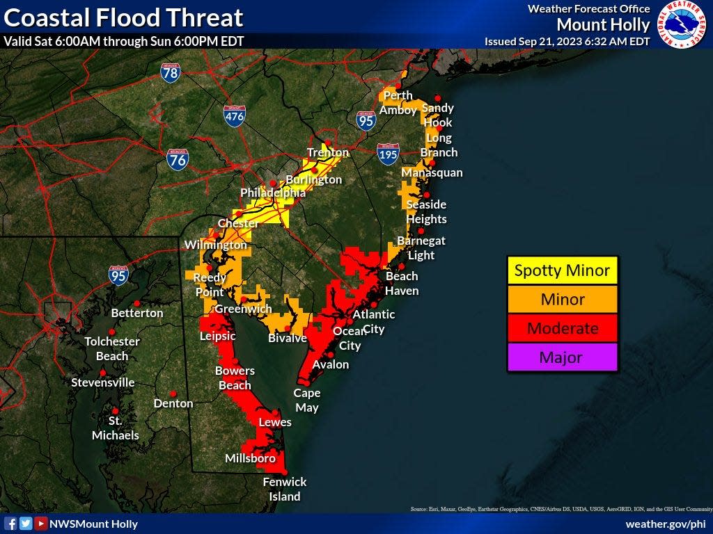
A coastal flood advisory remained in effect on Sunday morning.
However, the low pressure area associated with the storm "will continue to weaken as it moves toward southern NJ by this evening," said a forecast posted to the NWS website at 6:30 a.m. Sunday.
It said showers would be "light and spotty" across the region, and wind speeds should "slacken appreciably."
South Jersey felt Ophelia's impact on Saturday, with widespread rain, high winds and coastal flooding.
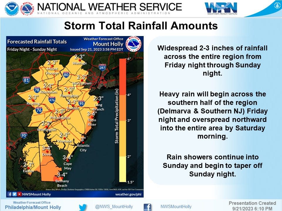
At about 7:15 p.m. Saturday, rainfall totaled almost three inches near Cape May Court House, 2.6 inches near Egg Harbor and 2.3 inches in Atlantic City.
The Weather Service said precipitation measured 1.74 inches in the Hammonton area, 1.4 inches around Vineland and about an inch near Pine Hill and South Harrison.
Atlantic City Electric said fewer than 500 customers lacked power at 9 a.m. Sunday, compared with about 2,500 customers some 12 hours earlier.
What's ahead for South Jersey?
Although the storm will move offshore on Monday, "it will remain closeenough by that some showers remain possible, particularly closerto the coasts of New Jersey and Delaware," the Weather Service said.
About a half-inch of rain could fall along the coastline through Tuesday night, "with a quarter of an inch or less inland."
"The other notable impact will be continued gusty winds, particularly on Monday," it said.
Ophelia was downgraded Saturday night from tropical storm status, which signifies sustained winds of 39 to 73 mph.
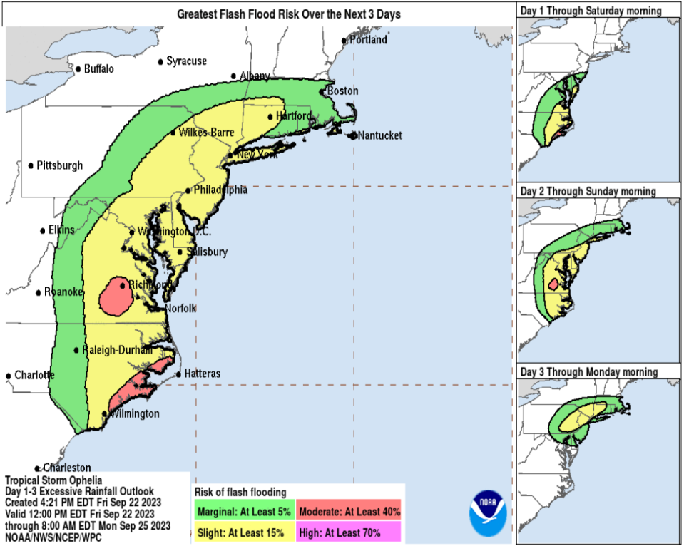
The National Hurricane Center previously had warned Ophelia could produce "flash and urban flooding" from North Carolina to New Jersey through Sunday.
It said ocean swells will affect much of the East Coast "through the weekend, likely causing life-threatening surf and rip currents."
A Weather Service storm report noted street flooding on Saturday in shore towns that included Avalon, Atlantic City, Margate, Ocean City and Sea Isle City.
It reported wind gusts on Saturday reached 61 mph in Sea Isle City, 51 mph in Strathmere and 50 mph in Atlantic City.
"I would describe this weekend's weather as pretty dismal," said Cameron Wunderlin, an NWS meteorologist in Westampton.
⚠️🌬️🌧️ The threat and confidence of impacts from the weekend coastal storm have increased. Widespread coastal flooding, strong to damaging winds, and locally heavy rain are expected. View our latest briefing package for details: https://t.co/04fTTyWc3M #NJwx #DEwx #MDwx #PAwx pic.twitter.com/PgUDxu09DU
— NWS Mount Holly (@NWS_MountHolly) September 21, 2023
"This is not going to be an outdoor weekend at all," he said.
"The data shows that the worse damper on weekend activities will occur on Saturday as opposed to Sunday, but you could still see rain throughout the day on Sunday, although the rain will taper off somewhat," Wunderlin said.
The wet weather washed out some events.
Haddon Township's Brauhaus Schmitz postponed its planned Oktoberfest on Haddon Avenue. The event is rescheduled for Saturday, Sept. 30.
Weather concerns also pushed back plans for a "Jeep Invasion" of about 400 vehicles on Ocean City's Boardwalk. It was rescheduled from Sept. 23 to Sunday, Oct. 15.
Margate's Fall Funfest on the Bay this weekend was canceled due to weather concerns. The event has only been canceled once in its 22-year history, according to the Margate Business Association.
More: Here are 9 fall festivals in South Jersey you don't want to miss
More: 6 fall productions to see from local South Jersey theaters
This article originally appeared on Cherry Hill Courier-Post: Weakening storm still packs a punch in South Jersey, particularly for coastal towns

