We explain how to track tropical storms and how far typical landmarks are from Florida
Every hurricane season, the National Hurricane Center and local officials encourage residents to be prepared and stay informed.
Staying informed includes knowing what's out there, the potential for development and how close something is to where you live.
The National Hurricane Center uses several common geographic locations to give readers an idea of where systems are, in addition to latitude and longitudes. Here's how to use that information and apply it to where you live.
How to find and use the National Hurricane Center's website
Bookmark these two websites from the National Hurricane Center:
National Hurricane Center: Three tabs — Central Atlantic, Eastern Pacific and Atlantic — provide information via advisories on named storms or tropical systems expected to impact land in the coming days.
Seven-Day Tropical Outlook: Also broken into the same three tabs, these is where the National Hurricane Center gives a longer-range look at low-pressure systems and tropical waves out there, what they're doing and where they're going.
As chances increase for development, forecasters start giving more detailed information the system, including chances for development over the next two and seven days.
How do you see where tropical waves are?
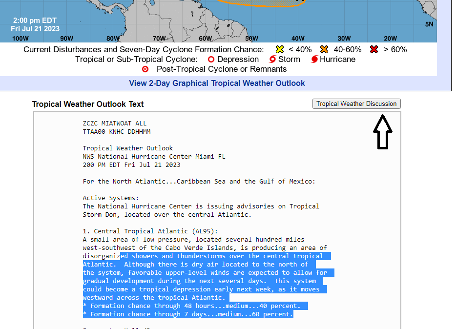
Under the tropical outlook, the National Hurricane Center has a button labeled Tropical Weather Discussion.
In this section, forecasters go into detail on what's happening, including any tropical waves they're keeping an eye on.
Typically, the information contains:
General information on where the tropical wave is.
Latitude and longitude.
How fast and the direction it's moving.
Any weather associated with the system at the current time, such as rain.
Best apps to help you: Stay prepared for the 2023 hurricane season with one of these five hurricane tracker apps
How do you use latitude and longitude to find where tropical systems are?
Not only does the National Hurricane Center use latitude and longitude to give more information on where tropical waves are, but you'll find those coordinates used to pinpoint the center of named storms.
Here's how to find where a system is:
Go to Google maps
Enter the latitude and longitude as precise as you'd like or go more basic with something like: 63.0W 19.0N
Hit the magnifying glass next to your coordinates
You'll probably see a red pin in a field of blue. Use the - button or slider until you see land.
General land areas and their distance from Florida
You'll see many tropical advisories contain the same land areas to help residents know where tropical waves and system are as they move across the Atlantic. Here's what you should know:
Cabo Verde: A group of islands off the western coast of Africa, more specifically, 387 miles west of Senegal.
Distance from Florida: 3,662 miles.
Lesser Antilles: The Lesser Antilles is a group of islands between the Caribbean Sea and the Atlantic Ocean. They include the Virgin Islands to the north to Grenada to the south. The Lesser Antilles includes the northerly Leeward Islands, the southeasterly Windward Islands, and the Leeward Antilles, just north of Venezuela.
Distance from the Virgin Islands to Miami: 1,122 miles.
Leeward Islands: The Leeward Islands are the northern group of islands making up the Lesser Antilles and located where the northeastern Caribbean Sea meets the western Atlantic Ocean. They include the Virgin Islands on the north to Guadeloupe on the south.
Distance from the northernmost (the Virgin Islands) to Miami to Florida: 1,122 miles
Windward Islands: The Windward Islands are the southern group of islands making up the Lesser Antilles and include Grenada, Saint Lucia, and Saint Vincent and the Grenadines.
Distance from Saint Lucia to Florida: 1,482 miles.
Bahamas: The Bahamas is a group of more than 3,000 islands, cays, and islets in the Atlantic Ocean that extend from north of Cuba to east of West Palm Beach.
Distance from Jacksonville: 997 miles.
Distance from the capital of Nassau to Miami: 180 miles.
Bermuda: Bermuda is an archipelago consisting of 181 islands in the Atlantic. Closest point to the U.S. is North Carolina at 673 miles.
Yucatan Peninsula: The Yucatan Peninsula separates the Gulf of Mexico from the Caribbean Sea and include three Mexican states along with portion of the countries of Belize and Guatemala. Popular tourist destination Cancún is located on the tip of the peninsula.
Distance from Cancún to Naples: 469 miles.
This article originally appeared on Treasure Coast Newspapers: Tracking tropical storms with latitude, longitude, distance Florida

