Explainer-What California's atmospheric rivers mean for drought, floods, fires
By Steve Gorman and Daniel Trotta
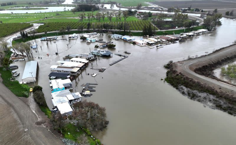
LOS ANGELES (Reuters) - California has experienced an exceptionally wet winter with 11 atmospheric rivers battering the state since late December. A twelfth such storm is due to land on Tuesday, threatening to cause even more flooding, landslides and road closures.
Atmospheric rivers are vast airborne currents of dense moisture carried aloft for hundreds of miles from the Pacific and funneled over land to fall as bouts of heavy rain and snow. Here's what such storms mean for the near and long term.
HOW MUCH RAIN HAS CALIFORNIA RECEIVED?
California has received 147% of average rainfall so far this season, according to the state Department of Water Resources.
IS THE DROUGHT OVER?
The U.S. Drought Monitor, an initiative of the University of Nebraska-Lincoln, deems California mostly drought free for the first time since 2020, with only the most arid regions in "severe" or "moderate" drought.
Just a few months ago, a color-coded map created by the monitor, which partners with the National Oceanic and Atmospheric Administration and the U.S. Department of Agriculture, showed large globs of the state in the red of "extreme" drought or deep red of "exceptional" drought. The driest areas were largely concentrated in the state's Central Valley agricultural lands.
Experts warn that California and the West have not escaped longer-term conditions that, according to one study, created the region's driest 22-year span in 12 centuries during the period of 2000 to 2021.
As Arizona State University hydrologist Jay Famiglietti put it: "Say you are broke. If someone gives you a check for $100, and you have money for a day, you're still broke."
During any normal 20-year period of the 20th century, about 10 years were wet and 10 years were dry - a sustainable ratio, said Thomas Harter of the University of California at Davis. During any normal 20-year period of the 20th century, about 10 years were wet and 10 years were dry - a sustainable ratio, Harter said. But in the past 25 years, only nine years were wet and 16 were dry, meaning the state needs seven more wet years to recover. And climate change points to future years that are likely to get warmer, exacerbating the increasingly dry climate.
HOW WELL HAS CALIFORNIA CAPTURED STORM WATER?
California's 20th century infrastructure was designed to rush water from north to south for irrigation, human consumption and flood prevention without much concern for recharging underground aquifers. As a result, stormwater runoff largely flows out to sea.
The state's Water Supply Strategy released last year calls for creating storage space for up to 4 million acre-feet (4.9 billion cubic meters) of water, enough for 8 million households in a state of 40 million people. Most of that would be kept in groundwater or underground storage. But the plan is new, as is California's way of thinking about how to adapt to drought with climate change. Although the state in recent years budgeted $8.7 billion for drought resilience, much of that destined for stormwater capture, the projects are mostly in their infancy.
HOW DOES THE RAIN AFFECT WILDFIRES?
This winter's bountiful rainfall has already triggered considerable growth in grasses and scrub that will dry out by summer, leaving a larger, thicker fuel bed for wildfires, said Isaac Sanchez, a battalion chief for the California Department of Forestry and Fire Protection (CalFire).
Still, larger shrubs and trees retain moisture, making them less prone to burning as rapidly as they might when completely desiccated by drought, said Ed Clark, director of NOAA's National Water Center.
The heavy rains can create dangers around burn scars from previous wildfires. The denuded land becomes susceptible to mudslides.
WHAT ABOUT THE COLORADO RIVER?
The basin of the overused Colorado River, which runs through seven Western states and part of Mexico, received comparatively little rainfall from the atmospheric rivers. Although snowfall in the mountains was substantial, the long-term state of the river remains dire.
Seven states form part of the 101-year-old Colorado River Compact dividing up the river's water rights: Arizona, California, Colorado, Nevada, New Mexico, Utah and Wyoming. Those states are attempting to renegotiate the agreement with a federal request to reduce exploitation of the river by some 15% to 30%.
Despite the temporary reprieve, the state of California, which receives the most Colorado River water, is not likely to negotiate away its senior rights just because its reservoirs are relatively full at the moment, experts said. Reducing Colorado River water usage may require federal intervention.
At least the snowfall saved Colorado River-fed Lake Powell and Lake Mead, the nation's two largest reservoirs, from imminent danger of falling to "dead pool" levels - the point where a dam can no longer produce hydroelectric power nor deliver water downstream.
(Reporting by Daniel Trotta in Carlsbad, Calif., and Steve Gorman in Los Angeles; Editing by Donna Bryson and Mark Porter)

