Explore our gorgeous planet in these stunning satellite images

We live on a beautiful planet.
We’re fortunate enough today to have a front-row seat to a view of our home that wasn’t possible until just 1960.
Today’s weather satellites give us a tremendously sharp look at Earth every couple of minutes. Anyone with access to the internet can look down upon our planet as it appeared just moments ago, a wonder unthinkable when the first weather satellite launched 63 years ago.
Few sights can rival gazing upon our blue marble and looking in awe at the countless features that spin and twirl and bubble and slosh around us on a seemingly infinite loop. It’s a sight that repeats every day, whether we’re basking in the comfort of blue skies or seeking shelter from extreme danger.
MUST SEE: Heads up! These six special clouds linger in our skies every day
This is what your world looked like on Sunday, September 24, 2023—likely an unremarkable day in the eventual course of history, but another masterpiece of natural beauty when you look close enough at all the fascinations that surrounded us on the first full day of autumn in the northern hemisphere.
GOES-East gazes upon countless clouds and endless swirls
If you’ve watched a mesmerizing loop of a hurricane churning in the Atlantic or powerful thunderstorms bubbling over Ontario, those views were sent back to Earth by NOAA’s GOES-East.
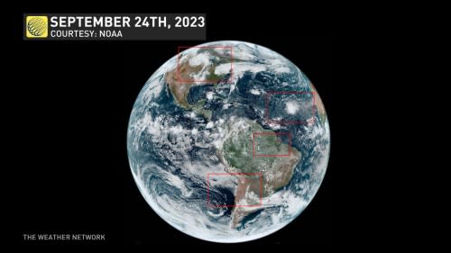
This satellite is parked in geostationary orbit—meaning that it orbits Earth at the same rate that our planet rotates, an arrangement that allows the satellite to stay in the exact same spot for its entire lifetime, providing a continuous view of our world for years on end.
Storms and smoke roll across Canada
Two storms stand out when you take a look at North America on this average Sunday in September.
The remnants of Tropical Storm Ophelia continue swirling over the Mid-Atlantic states after its strong winds brought major coastal flooding and tens of thousands of power outages across North Carolina and Virginia on Saturday.
But the standout is a picturesque low-pressure system spinning over the Upper Midwest, which sent a cold front extending thousands of kilometres south toward the Gulf of Mexico.

This striking front brought powerful thunderstorms to parts of the U.S. Plains on Saturday, some of which produced hailstones larger than baseballs.
Clouds perfectly swirl into the centre of the low, standing out even more boldly surrounded by the pristine clear skies over the Great Lakes and northern Prairies.
Also standing out against the crisp autumn sky, sadly, are thick plumes of wildfire smoke flowing across northern Canada.
Fires continue to burn throughout portions of Western Canada, chugging out such thick smoke that the sky in Yellowknife fell to a murky darkness much of the day Sunday.
WATCH: A sign of the times, B.C.’s fires may burn until winter
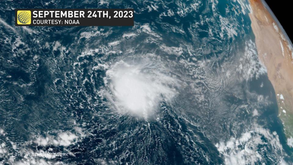
Tropical Storm Philippe pinwheels over the Atlantic
The seventeenth tropical storm of this year’s remarkable Atlantic hurricane season formed deep in the Atlantic on Saturday. Philippe’s formation is remarkable given that Atlantic hurricane activity is usually stifled during a strengthening El Niño over in the Pacific Ocean.
CHECK IT OUT: How a mammoth hurricane rapidly intensifies in mere hours
Philippe is a stout little storm as it slowly meanders west across the open waters. Wind shear will soon press against the storm, hampering its ability to take advantage of record-warm sea surface temperatures and continue building strength.
Despite its size and looming struggles, Tropical Storm Philippe looked solid on Sunday, and the spiraling winds flowing into the storm are visible for thousands of kilometres as clouds gradually curve toward the fledgling system.
Countless puffy clouds blossom over the Amazon
Satellites give us views of places most of us could only dream of visiting.
The skies over the Amazon River basin are rarely clear. Heat and humidity blankets the region year-round, keeping the water cycle turning at full speed in this corner of the world.
Puffy fair-weather cumulus clouds rise over the rainforest clockwork with the morning sun.

Bright sunshine warms the land unevenly, allowing pockets of moist air to rise and condense into a sea of cotton balls. These clouds organize into fascinating patterns as they trace the outline of prevailing winds blowing over the diverse ecosystem.
The only clearings in the afternoon skies appear over bodies of water, which don’t warm up as quickly as solid land. This effect allows lakes and rivers to appear etched through the fields of clouds.
Actinoform clouds build off the chilly Chilean coast
Chile’s Atacama Desert is one of the driest places on Earth in large part because of the frigid waters of the eastern Pacific Ocean.
Intense upwelling here forces deep, cold ocean water to rise to the surface, combining with the rain-shadow effect of the Andes to prevent much precipitation—or even clouds—from forming over this Mars-like terrain.

DON’T MISS: Seven times weather unexpectedly changed the course of history
Over the ocean, though, clouds band together in mysterious formations that meteorologists didn’t even know existed until the first weather satellites went up in the 1960s.
These actinoform clouds cover thousands of square kilometres above the ocean, forming into large, intricate patterns.
A powerful storm aims for British Columbia
GOES-East’s twin satellite, aptly named GOES-West, keeps watch over the western Americas and a vast portion of the Pacific Ocean.
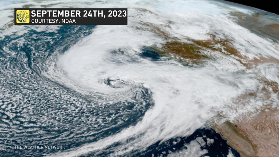
This companion satellite allows us to keep watch over storms making their way toward the West Coast, so vast that they can stretch thousands of kilometres from one end to the next.
We’ve got just such a storm heading toward B.C. to start the final week of September.
This system’s expansive reach—which is mesmerizing to witness from above—will force plenty of Pacific moisture into the skies over the province, allowing for soaking rains over the next couple of days.
Given the storm’s size and intensity, we could also see damaging winds up to 90 km/h for coastal sections of Vancouver Island through Monday.
Header image courtesy of NOAA.

