Extreme heat, fire danger, severe weather possible in Oklahoma Tuesday through Thursday
Oklahomans can expect a confusing week of weather extremes, starting with a day of hot and humid temperatures progressing into a night of potential severe rainfall Tuesday.
After a week of tornadic activity and a weekend of unseasonably hot temperatures, meteorologists expect severe weather risk to return to regions of Oklahoma.
Parts of the state as far north as Enid and as far south as Altus range from "slight" to "enhanced" for chances of storms, forecasters said.
"The greatest potential looks like it's going to be in southwestern Oklahoma and western north Texas (Tuesday) night," said meteorologist Phil Ware with the National Weather Service in Norman. "The risk decreases as you head eastward."
Related: What we know about the severe weather this week in Oklahoma
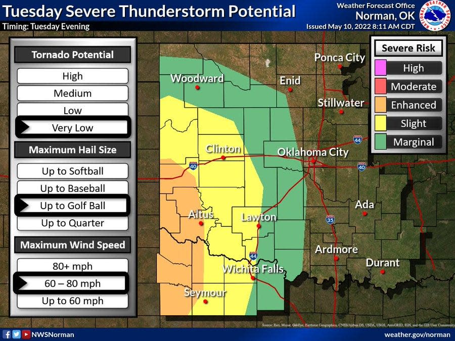
The Oklahoma City metro sits in the outermost margin of the projected risk area, and the forecast for tornadoes in the entire area is very low, according to Ware.
"The conditions right now are just really not favorable at all for tornadoes, but they are very favorable for straight-line winds, and that looks like it's going to be our main concern," Ware said. "You're going to see a sort of broken line of storms develop in the Texas panhandle and move east (Tuesday) evening."
The high-speed winds bring the major risk of critical fire weather, which can increase the spread of wildfires should a blaze be ignited amid the extreme heat. Experts said northwest Oklahoma, already experiencing severe drought conditions for several months, could see temperatures reach as high as 102 degrees.
"The other major portion of that fire weather danger is the relative humidity," Ware said. "But when you factor how dry the air is, most of the drier air for much of this week should stay to the west of the state, for the most part. And that should actually help to limit the worst fire weather potential this week, along with more and more of the rainfall we've been seeing."
More: Will severe weather affect Oklahoma Tuesday? Forecasters unsure
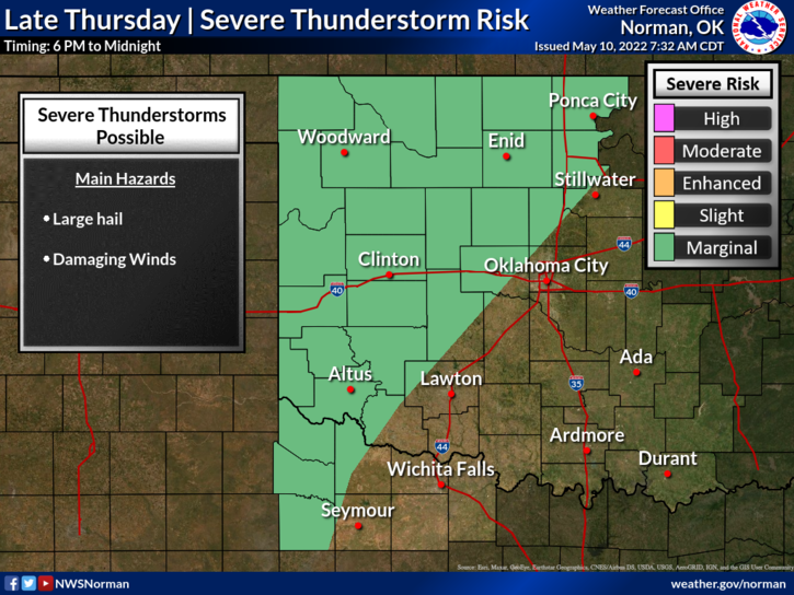
Forecasters expect chances as low as 20% for severe weather potential through Saturday in central Oklahoma, with the highest risk returning late Thursday.
"The risk on Thursday is more focused on areas in western and northern Oklahoma, not so much the Oklahoma City area," Ware said.
The jet stream, a high-speed air current in the highest part of the atmosphere, typically guides storms from west to east, and that flow of air is tilting further north of the Central Great Plains.
"That really removes one of the main ingredients of winds here from the equation," Ware said. "It prevents storms from becoming more organized, and it's keeping most of the storm chances to the west and the north of Oklahoma for the middle of the month."
This article originally appeared on Oklahoman: Fire weather, severe storms possible, but tornado chances low for OKC

