Extreme weather ahead: Dangerous winds, rain, snow and wind chills coming to northern Ohio
Hold onto your hats.
It's about to get super windy − again.
And keep that hat handy as it is about to get super cold.
Yet another storm system will make its way through northern Ohio this weekend.
It will bring a bit of everything from rain to high winds to snow to bitter cold.
High wind warning for northern Ohio
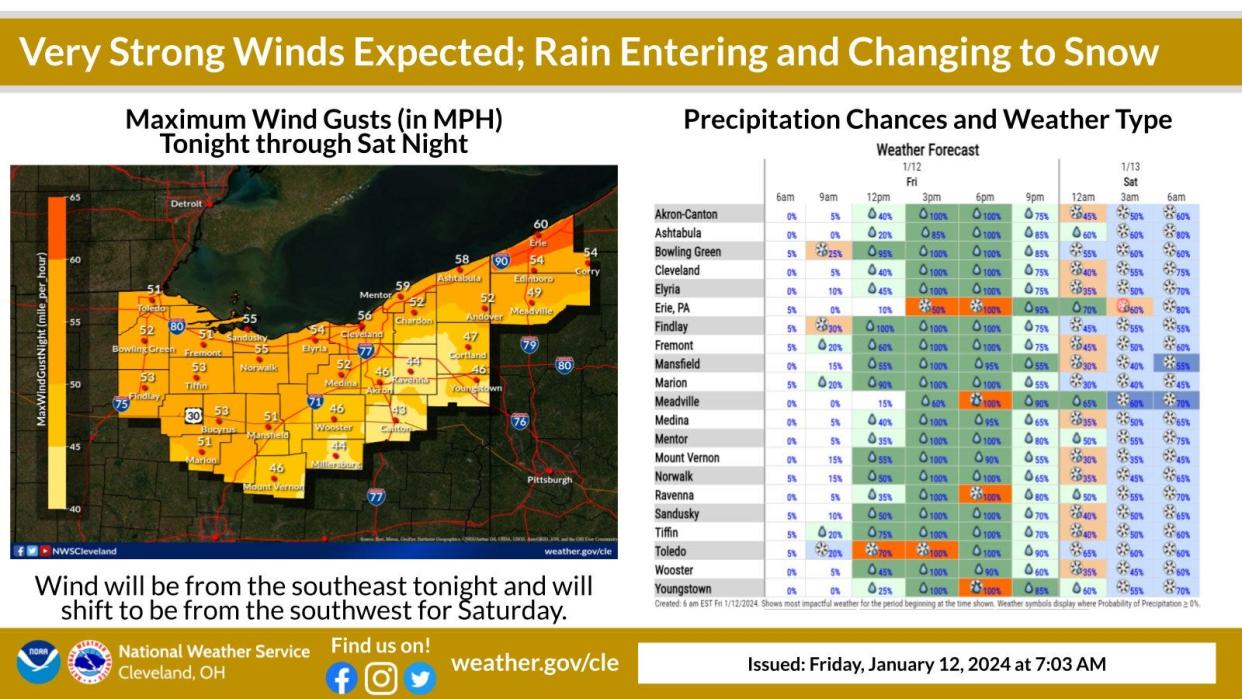
First will come the rain and wind.
The National Weather Service has issued a high wind warning starting at 4 p.m. Friday and running through 7 p.m. Saturday.
Winds of anywhere from 25 to 35 mph are expected.
Some wind gusts of up to 60 mph are possible.
The weather service warns some tree limbs may fall and even power outages are possible.
"Damaging winds will blow down trees and power lines," the weather service says. "Widespread power outages are expected.
"Travel will be difficult, especially for high profile vehicles."
The high winds are expected to come in waves.
"The two windows of strongest wind gusts will be late this evening and then Saturday morning and afternoon," the weather service says. "Gusts over 40 mph can linger through Saturday evening."
Rain is expected to switch over to snow early Saturday morning with snow showers expected daily through Tuesday.
Arctic Blast expected in northern Ohio
The passage of the storm system will bring with it the coldest temperatures so far this winter and dangerous wind chills.
"An Arctic airmass will arrive this weekend, with an extended period of sub-zero wind chills Saturday night through Wednesday," the weather service says.
Daily highs will be in the teens starting Sunday with lows in the single digits through Tuesday night.
Akron opens warming centers
To help residents cope with the cold temperatures, Akron plans to offer places for residents keep warm.
The city is extending hours at Summit Lake Community Center at 380 W. Crosier St. starting Sunday through Tuesday.
The Center will be open between 8 a.m. through 7 p.m.
The city's other community centers plan to be open during normal hours over the holiday weekend.
Mayor Shammas Malik said the city is monitoring the weather and may consider extending the hours at the so-called warming centers. Unless otherwise specified, the centers will return to their normal business hours starting Wednesday.
The Emergency Overnight Shelter , which is a partnership between the Peter Maurin Center, Summit County Continuum of Care, and Community Support Services, at 111 East Voris St. in Akron plans to open Saturday and be open from 7 p.m. to 8 a.m. through Monday, Jan. 22.
“With frigid temperatures setting in this weekend, we want to make sure everyone has somewhere to go to keep warm and be out of the elements,” Malik said in a release. "I applaud the efforts of the organizations collaborating on the emergency overnight shelter to keep folks sheltered during the coldest periods at night. We’ve set our hours to correspond with theirs so that no matter the time, residents will have somewhere to go.”
For more, visit akronemergencyshelter.org.
Ohio Turnpike travel ban
The Ohio Turnpike is issuing a travel ban in anticipation of the expected high winds.
Starting at midnight Saturday morning through 6 p.m. Saturday certain high-profile vehicles will be banned from the 241-mile toll road.
The vehicles subject to the ban are ones whose height .
High-profile vehicles are defined as height exceeding 7 feet and 6 inches.
Those vehicles subject to the ban include:
All high-profile tow-behind trailers, campers, boats, and enclosed trailers. (Fifth wheel trailers are excluded.);
Commercial trucks towing an empty single 53-foot trailer;
All mobile homes, office trailers and livestock trailers;
All long combination vehicles (LCV) that include long double-trailer combinations exceeding 90-feet in length. (Enclosed trailers only, including Conestoga type trailers); and
All LCV triple-trailer combinations.
What's the forecast?
Friday: Showers, mainly after 2 p.m. High near 45. Breezy, with a southeast wind 14 to 24 mph, with gusts as high as 41 mph. Chance of precipitation is 100 percent. New precipitation amounts between a quarter and half of an inch possible.
Friday night: Rain and snow showers before 4 a.m., then a chance of snow showers. Low around 28. Windy, with a southeast wind 24 to 26 mph becoming southwest after midnight. Winds could gust as high as 46 mph. Chance of precipitation is 90 percent. New snow accumulation of less than a half inch possible.
Saturday: Snow showers likely, mainly before 11 a.m. Patchy blowing snow before 11 a.m. Cloudy, with a high near 29. Windy, with a southwest wind 26 to 29 mph, with gusts as high as 44 mph. Chance of precipitation is 70 percent. New snow accumulation of less than one inch possible.
Saturday night: A chance of snow showers. Patchy blowing snow between 11 p.m. and 1 a.m. Cloudy, with a low around 14. Breezy, with a southwest wind 18 to 23 mph, with gusts as high as 37 mph. Chance of precipitation is 50 percent. New snow accumulation of less than one inch possible.
Sunday: A chance of snow showers, mainly before 1 p.m. Patchy blowing snow before 4 p.m. Mostly cloudy, with a high near 18. Breezy, with a west wind 20 to 22 mph. Chance of precipitation is 30 percent. New snow accumulation of less than a half inch possible.
Sunday night: A slight chance of snow showers. Mostly cloudy, with a low around 7. Chance of precipitation is 20 percent.
Martin Luther King Jr. Day: A chance of snow showers. Mostly cloudy, with a high near 18. Chance of precipitation is 30 percent.
Monday night: A chance of snow showers. Mostly cloudy, with a low around 10. Chance of precipitation is 40 percent.
Tuesday: A chance of snow showers. Mostly cloudy, with a high near 17. Chance of precipitation is 50 percent.
Tuesday night: A chance of snow showers before 1 a.m. Mostly cloudy, with a low around 3. Chance of precipitation is 40 percent.
Wednesday: Partly sunny, with a high near 18.
Wednesday night: A chance of snow showers. Mostly cloudy, with a low around 14. Chance of precipitation is 30 percent.
Thursday: A chance of snow showers. Mostly cloudy, with a high near 26. Chance of precipitation is 40 percent.
Reporter Derek Kreider contributed to this article.
This article originally appeared on Akron Beacon Journal: High winds rain snow and dangerous wind chills coming to northern Ohio

