Facing constant sand erosion, Longboat Key restores lagoon’s link to Sarasota Bay
It’s Longboat Key’s sand.
They paid for a lot of it, they wanted to enjoy it and they wanted it back.
A project recently completed just east of the Longboat Pass bridge on the north end of the island accomplished a lot of that in one swoop. But it wasn’t exactly a pail-and-shovel endeavor, and it wasn’t exactly a proposal that happened at the snap of a finger.
The Canal 1A project, conceived in 2018 for about $1.1 million in construction fees, served two purposes: shaving down the ever-growing spit of sand that at times has cut access to the lagoon at the center of Greer Island; and returning thousands of cubic yards of that sand to gulf-facing beaches nearby.
“The sand goes right back on the beach, which is where it was supposed to stay originally, just that sand never really stays where you want it to,’’ Town Manager Howard Tipton said recently in his monthly report to town residents. “It’s either moving north and south or east and west.’’
The sand wasn’t doing residents and visitors much good on the east side of the Longboat Pass bridge linking Anna Maria Island and Longboat Key. In fact, sand through the years, and most recently after a multi-million dollar beach renourishment project up and down the shoreline, has consistently flowed off the northern beaches and piled up in places it never was before.
A lot of sand flowed around the northern tip of Longboat Key and gathered just north of the Land’s End community, at times making it possible to walk through ankle-deep water from the beach to a nearby private dock.
Two previous, smaller, emergency dredge jobs reopened the passage, which is known as Canal 1A, only to have it close up again.
Though forbidden from beaching along the now-smaller sand spit, Armando Carbajal on a recent lunchtime beached his outboard craft along the S-curve-shaped southern shore of Longboat Pass and walked under the span to cast his line.
“It’s one of my favorite spots, even if I have to walk a little,’’ he said.
A previous town manager of Longboat Key called the area’s shoreline one of the most dynamic in the region. Assistant Public Works Director Charlie Mopps in 2020 said the region was a “unicorn’’ because sand movement often runs contrary to prevailing currents.
To fix the issue, the town looked to the past.
Mopps told Tipton in the recorded monthly address that the goal of the Canal 1A project was to return the shape of Greer Island to that of 15 years ago and pile up the 19,000 wayward cubic yards of sand between a series of five concrete structures called groins, designed to hold that sugary white sand in place against the forces that normally want to move it from the gulffront through Longboat Pass.
“What we’re trying to do is re-create the conditions back in 2007, 2008 when there was not so much of the spit on the east side of bridge, but still a nice boatable area where you could beach your boat on the west side,’’ he said, adding the town had to gain permits from the U.S. Army Corps of Engineers, the Florida Department of Environmental Protection and, because of the bridge’s proximity, the Florida Department of Transportation. Of the project’s original cost borne by town taxpayers, about 28% is subject to state reimbursement, he said.
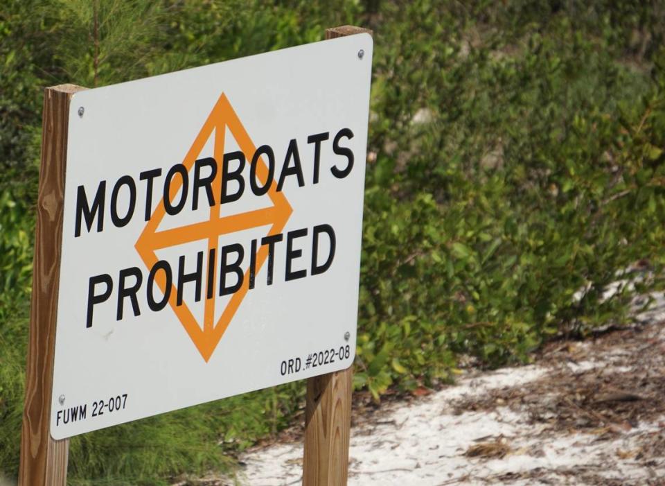
Aside from putting the sand in the rightful spot, the town also had for years been dealing with crowds of occasionally rowdy boaters who congregated on the sand spit and occasionally entered the lagoon. Town officials in 2022 erected signs near the iconic wooden fish marker near Land’s End, putting the lagoon off limits to come-and-go boating and restricting powerboat access elsewhere nearby.
Residents are still allowed to depart and return to their docks in the cove through a narrow channel, now open to the bay again. At times in the past, even kayaks or paddleboards bottomed out, residents said.
Mopps said not only was the town concerned about lagoon-side residents’ access rights to the open water – what property lawyers call riparian rights – but wildlife, also.
With Canal 1A open again, tidal water can come and go, too. Along with scores of different animals.
“You have manatees going in there, a lot of jellyfish, just a lot of different things happen within that nice little ecosystem,’’ he said. “Because that spit was growing, not only the boaters who live back there were going to be limited, and also the (tidal) flushing was going to be limited.’’
Eric Garwood is executive editor of the Community News Collaborative. Reach him at ericgarwood@cncfl.org.

