Potent storm arriving in B.C. with gusty winds, heavy rains
The first of several wet systems arriving on the West Coast will sweep across British Columbia’s South Coast overnight Sunday into Monday, bringing high winds and steady rains to much of the region.
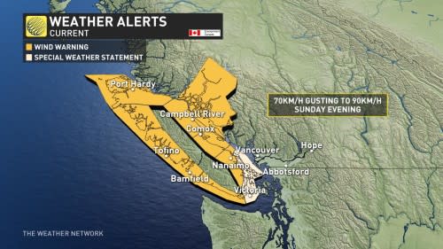
While the rain is a welcome sight for a region that desperately needs some relief, wind warnings are in effect for some areas as gusts could grow strong enough to cause tree damage and power outages.
DON'T MISS: Canada's summer defined by record wildfires, damaging floods and storms
Significant storm arrives on the West Coast
Areas: South Coast
Timing: Through next week
Weather: A large dip in the jet stream will send an active storm track streaming over the West Coast as we end September, allowing several moisture-laden systems to sweep through the region.
The first system pushed in late Sunday with plans to stick around into Monday, spreading gusty and potentially damaging winds across Vancouver Island and exposed coastal regions.
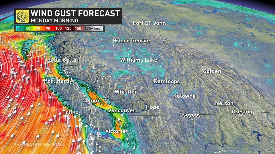
Winds will peak overnight Sunday into Monday morning, with gusts near 80 km/h for northern sections of the Strait of Georgia, 90 km/h for west Vancouver Island, and 40-60 km/h across the west end of the Lower Mainland.
Communities under wind warnings should remain on alert for the risk for damage and power outages. Trees in the region are stressed and still have full foliage, which could boost the risk for downed trees and power lines in spots. Residents should prepare for the potential for localized power outages, as well as the risk for travel disruptions heading into Monday.
CHECK IT OUT: Explore our gorgeous planet in these stunning satellite images
These rounds of precipitation could offer much-needed relief to areas that have spent the majority of summer covered by the highest level of drought on Environment and Climate Change Canada’s (ECCC) scale to measure the impact of abnormally dry conditions.
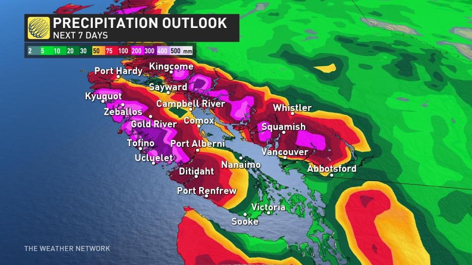
Forecasters have high confidence in the arrival of a pattern change, but medium confidence in precipitation totals throughout the week. We’re likely on track to see 50-100 mm of rain across the Lower Mainland over the next seven days, with the potential for 200 mm of precipitation falling at higher elevations. Alpine snow is possible at times for areas above 2000 m.
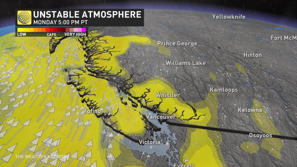
Given the instability arriving with the storm, a few rumbles of thunder can’t be ruled out during bouts of heavier rain.
The arrival of bountiful rains is an abrupt turnaround for parts of the region. Even though summertime is typically B.C.’s driest stretch of the year, Vancouver had only seen about 16 per cent of its usual September rainfall through Sept. 20.
Unfortunately, many areas throughout the Interior that desperately need precipitation will miss out on significant amounts of beneficial rain. The slug of Pacific moisture will wring itself out over coastal communities, not leaving much left to arrive in the Okanagan or points east.
WATCH: Canada’s summer was a season of records and astonishing sights
Atmospheric river ranked as Category 3
An atmospheric river streaming in from the Pacific will give these systems plenty of moisture to work with.
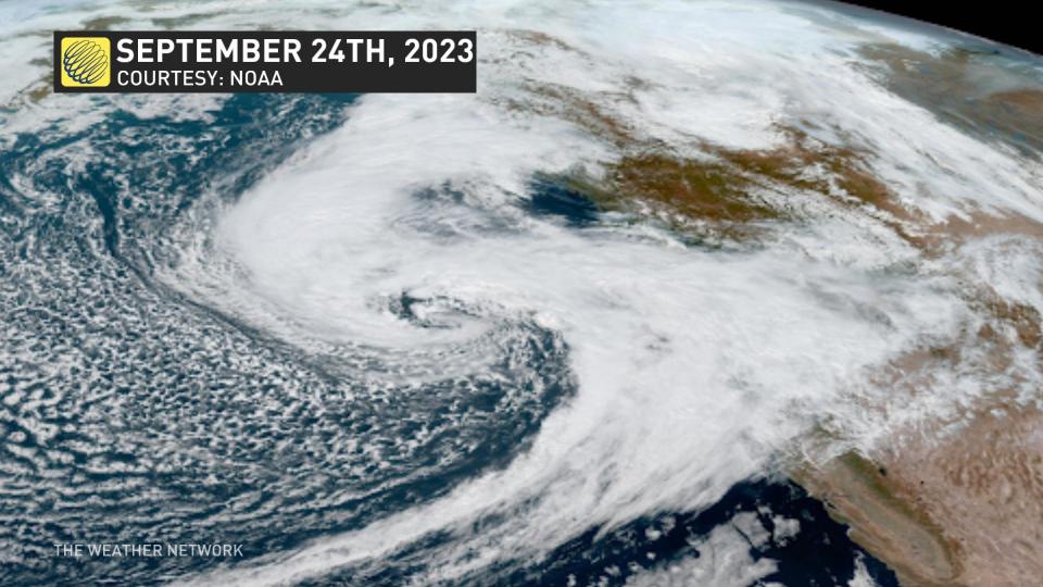
The impending slug of moisture will rank as a Category 3 on the University of California San Diego’s atmospheric river scale, which ranks the duration and magnitude of these plumes of moisture as they stream into the West Coast.
RELATED: Why we see floods following fires: A tale of two extremes
Category 3 atmospheric rivers are both beneficial and hazardous, bringing quenching rains that could also lead to localized flooding if it falls too quickly.
Header image courtesy of Unsplash.
Stay with The Weather Network for all the latest on conditions across B.C.

