Fantastic clouds, their significance, and where to find them
Clouds are a common-place item in our skies. They’re so common, in fact, that we tend not to notice them. They can look anywhere from a plain blanket over the sky to a beautiful work of art, or sometimes to an apocalyptic look that makes you feel like you must be in a movie; and it’s when those beautiful or scary clouds paint the sky that people’s heads (and cameras) turn up.
The three most basic cloud types are cumulus clouds, stratus clouds, and cirrus clouds. These three types are essentially the overarching foundation for all other types and subtypes of clouds.
The plethora of cloud subtypes range from being fairly common to extremely rare.
A cloud type is considered ‘rare’ if it only forms under extremely precise atmospheric conditions. Granted, all clouds can only form under certain basic conditions, but those conditions are usually just the level of atmospheric stability, moisture, and temperature.
RELATED: Heads up! These six special clouds linger in our skies every day
There are several other conditions that can come together to form the stunning clouds we love to gaze at, such as topography, jet stream location, and upper wind velocity.
Here are just a handful of fantastic clouds, how they form, and where you are more likely to find them in Canada.
Asperitas clouds
Asperitas clouds over Sault Ste. Marie, Ont. Taken Oct. 9, 2020. (Anika Beaudry)
Asperitas clouds are definitely one of the more apocalyptic-looking clouds on this list. Looking at these clouds may make you feel like you’re standing on the bottom of the ocean, watching the waves churn above you.
Asperitas clouds are so uncommon that they weren’t even officially recognized by the World Meteorological Association until 2015.
The jury is still out about how exactly these fascinating clouds form, however. They can form anywhere in Canada and often, but not always, follow after a thunderstorm. This falls in line with the hypothesis that asperita clouds form due to the instability and convection in the atmosphere associated with thunderstorms.
So, if you live somewhere that gets frequent thunderstorms in the summertime, you may be more likely to see these scary-looking (but harmless) clouds.
Fallstreak clouds
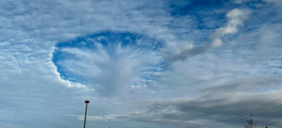
Fallstreak clouds form when supercooled clouds are disturbed by planes flying through them. (Jan Baker/Submitted)
Also known as ‘hole-punch’ clouds, fallstreak clouds are exactly what they sound like — clouds that look like someone punched a hole in the sky. This interesting phenomenon happens when mid- to high-level clouds are supercooled, meaning the water in the clouds is below freezing temperature but is not crystalline. Supercooled water is incredibly sensitive and as soon as there is a disturbance, it will quickly crystallize into ice.
Supercooled clouds themselves sound like they should be rare, but they really aren’t. We just don’t see them because they look like every other cloud.
So, what could disturb clouds high in the sky? Planes!
As a plane flies through a supercooled cloud, the air surrounding the wings will expand and forcibly cool. This can, but doesn’t always, result in the supercooled water droplets crystallizing and absorbing other nearby droplets. The newly formed ice crystals are subsequently heavier than the liquid water droplets and will begin to fall to a lower level in the atmosphere.
If you happen to live on a flight route, you’ll likely see this phenomenon once in a while.
Kelvin-Helmholtz clouds
Kelvin-Helmholtz clouds over Grand Forks, B.C. Taken Feb. 7, 2023. (Alongthewaytoday Steve C/Submitted)
Have you ever seen cresting waves in the sky? Then you just may have seen Kelvin-Helmholtz clouds. These clouds may look like ominous, massive waves towering in the distance, but luckily they only look menacing.
Kelvin-Helmholtz clouds are formed when there is a sharp difference in wind velocities between the bottom of the cloud and the top.
They get their name, Kelvin-Helmholtz, from two physicists who studied the type of instability that leads to the difference in wind velocities needed for these clouds to form.
While you can spot these clouds anywhere in Canada, you’ll only be able to on windy days.
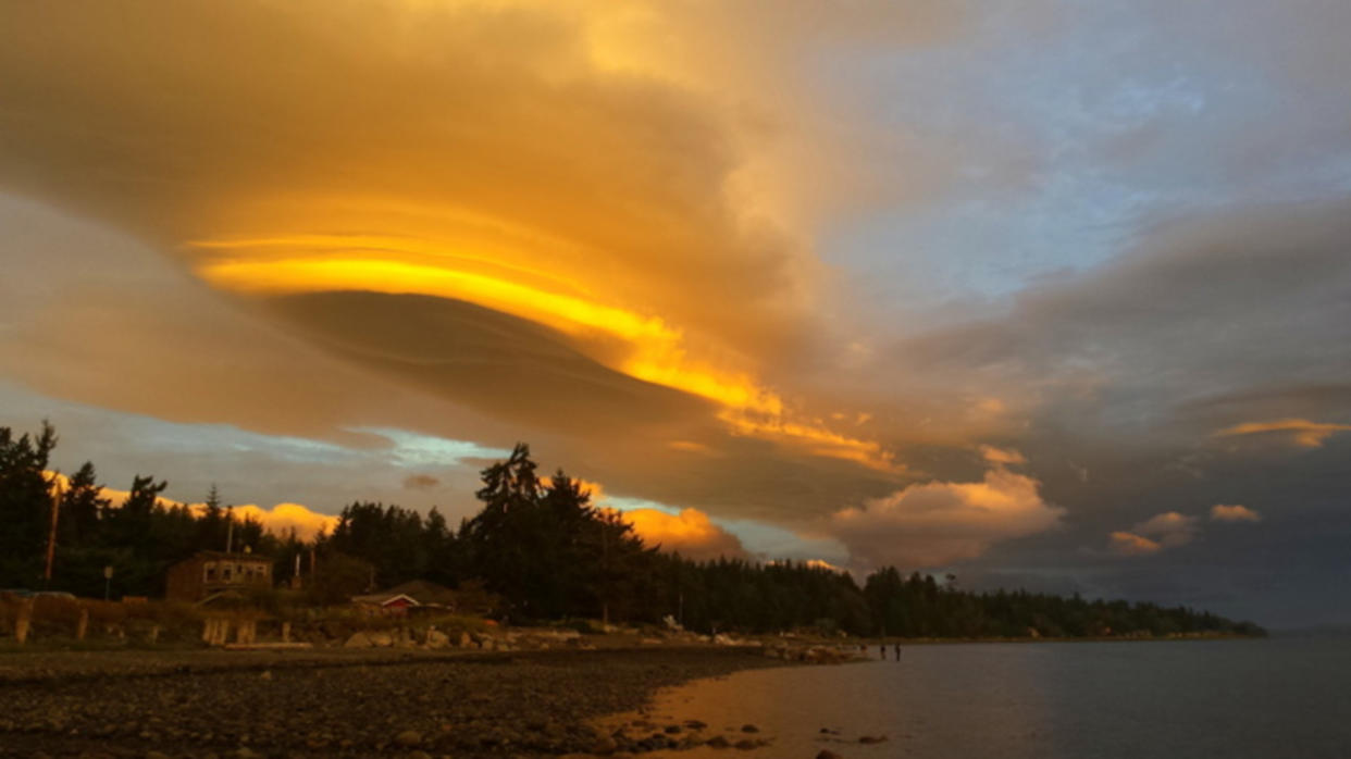
Lenticular clouds
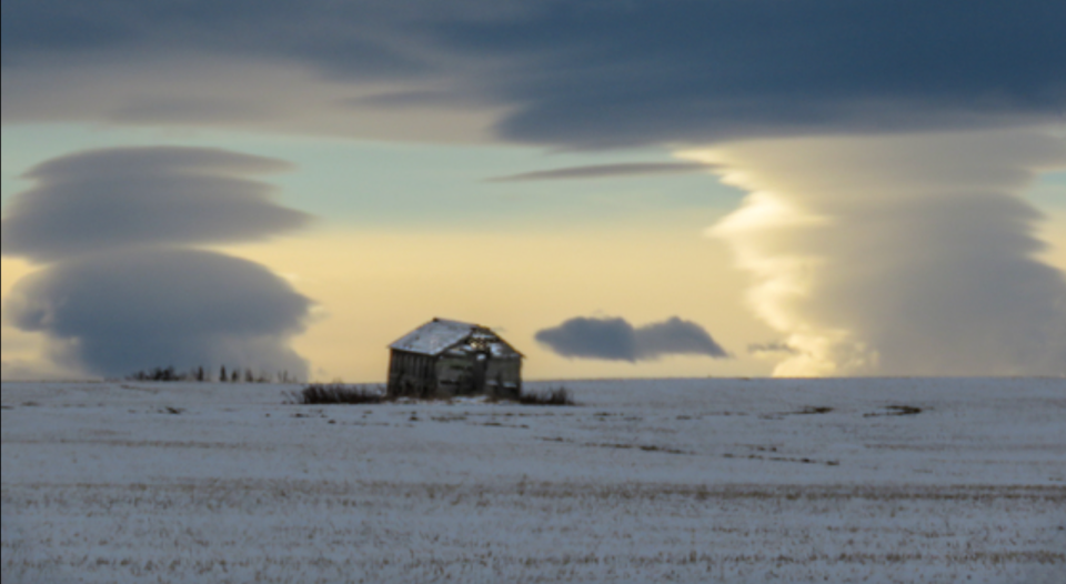
Lenticular clouds just outside of Calgary, Alta. Taken Dec. 15, 2020. (Anne Elliott/Submitted)
These clouds may look extraterrestrial, but they are actually anything but that. In fact, lenticular clouds are formed orographically, meaning they are formed from mountains and mountain ranges.
As air flows through a mountain range or around a mountainscape, the large outjutting of earth can displace some of that airflow upwards. The best way to picture it is by imagining the air as a current of water — both are fluid and dynamic — and when you place an object in the current, water will part around as well as above it, creating a ripple of water directly downstream from the object. Imagine that the current of water is actually a current of air, and the object is a large mountain. The same thing happens; only now, if the air has enough moisture and the temperature at its level is at the dew point, it will condense in a way where we can actually see the ripples of air as clouds.
You’re most likely to see this out-of-this-world phenomenon around mountainous areas, like around the Rockies in Alberta and British Columbia or the Laurentian mountains in Quebec. But don’t worry if you don’t live around these mountain ranges; lenticular clouds can also form around smaller, stand-alone mountains or large hills.
Mammatus clouds
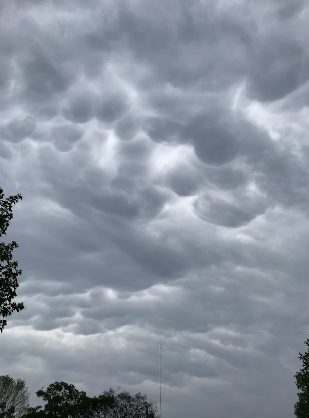
Mammatus clouds over Fort Frances, Ont. Taken June 4, 2019. (Anika Beaudry)
Mammatus clouds are another rare cloud that gives the sky an apocalyptic look. This isn’t helped by the fact that they are often associated with powerful thunderstorms due to the large amount of atmospheric instability they bring with them.
These giant bubbles in the sky are formed when pockets of dense, cold air aloft sink down, and instead of upward cloud growth, we see downward cloud growth.
More often than not, mammatus clouds will be seen before or after a severe thunderstorm and can sometimes even produce their own precipitation. They are more likely to be found with daytime storms as the atmosphere tends to be less stable during the day than at night.
So, like with asperitas clouds, if you are somewhere that tends to get more frequent powerful storms, you may be able to catch a glimpse of these giant bubbles.
Noctilucent clouds
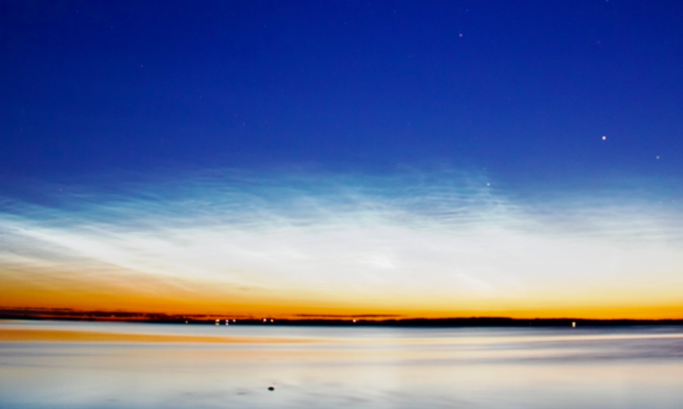
Noctilucent clouds glowing across Alberta skies. (Jeff Adams/Submitted)
Noctilucent clouds look like they may have come straight out of a fantasy novel. Why? Because they ‘glow!’
Noctilucent clouds get their cosmic glow from the microscopic ice crystals that form them, reflecting sunlight from just beyond the horizon as the sun finishes setting. This gives the wispy clouds a blueish-greyish glow that stands out in the night sky.
While almost all clouds form and stay within the troposphere, noctilucent clouds form much, much higher in the mesosphere. But dust and water vapour from the troposphere don’t generally reach such heights, so how are the clouds able to form? While research is still being done to definitively answer this question, it is highly believed that these essential components are of cosmic origin, such as from meteors burning up in the atmosphere.
Extremely cold temperatures in the mesosphere are also a must for these cosmic clouds, and luckily, Canada is in just the right spot. However, the mesosphere only ever reaches the required temperatures for these clouds to form in the summer months.
While you may see noctilucent clouds anywhere in Canada, you’re more likely to see them the farther north you are. This is especially true as you approach the Arctic Circle, where the temperatures are cooler and the sun doesn’t set too far beyond the horizon.
See interesting clouds in your sky? Share your photos with us, here! We’d love to see them!
Thumbnail image of lenticular clouds in British Columbia submitted by Duane Harding.

